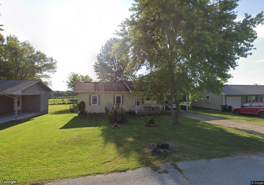
2005 Cedar Ridge Rd Harrison, AR 72601
Estimated Value: $122,948 - $170,000
3
Beds
1
Bath
1,136
Sq Ft
$130/Sq Ft
Est. Value
About This Home
This home is located at 2005 Cedar Ridge Rd, Harrison, AR 72601 and is currently estimated at $147,487, approximately $129 per square foot. 2005 Cedar Ridge Rd is a home located in Boone County with nearby schools including Skyline Heights Elementary School, Harrison Jr. High School, and Harrison High School.
Ownership History
Date
Name
Owned For
Owner Type
Purchase Details
Closed on
Sep 1, 2010
Sold by
Clark Mary L B and Mcentire Joann
Bought by
Poppert Keith and Poppert Mary
Current Estimated Value
Home Financials for this Owner
Home Financials are based on the most recent Mortgage that was taken out on this home.
Original Mortgage
$78,000
Outstanding Balance
$51,670
Interest Rate
4.58%
Mortgage Type
New Conventional
Estimated Equity
$95,817
Purchase Details
Closed on
Oct 12, 2007
Sold by
Blanknship Pauline
Bought by
Clrk Mary L D
Purchase Details
Closed on
May 6, 2004
Bought by
Blankenship and Clark
Create a Home Valuation Report for This Property
The Home Valuation Report is an in-depth analysis detailing your home's value as well as a comparison with similar homes in the area
Home Values in the Area
Average Home Value in this Area
Purchase History
| Date | Buyer | Sale Price | Title Company |
|---|---|---|---|
| Poppert Keith | $78,000 | -- | |
| Clrk Mary L D | -- | None Available | |
| Blankenship | -- | -- |
Source: Public Records
Mortgage History
| Date | Status | Borrower | Loan Amount |
|---|---|---|---|
| Open | Poppert Keith | $78,000 |
Source: Public Records
Tax History Compared to Growth
Tax History
| Year | Tax Paid | Tax Assessment Tax Assessment Total Assessment is a certain percentage of the fair market value that is determined by local assessors to be the total taxable value of land and additions on the property. | Land | Improvement |
|---|---|---|---|---|
| 2025 | $560 | $16,660 | $2,000 | $14,660 |
| 2024 | $560 | $16,660 | $2,000 | $14,660 |
| 2023 | $560 | $16,660 | $2,000 | $14,660 |
| 2022 | $185 | $16,660 | $2,000 | $14,660 |
| 2021 | $185 | $16,660 | $2,000 | $14,660 |
| 2020 | $185 | $14,190 | $2,000 | $12,190 |
| 2019 | $203 | $14,190 | $2,000 | $12,190 |
| 2018 | $228 | $14,190 | $2,000 | $12,190 |
| 2017 | $210 | $14,190 | $2,000 | $12,190 |
| 2016 | $210 | $10,990 | $2,000 | $8,990 |
| 2015 | $560 | $10,990 | $2,000 | $8,990 |
| 2014 | $210 | $10,990 | $2,000 | $8,990 |
Source: Public Records
Map
Nearby Homes
- 2014 Cedar Ridge Rd
- 1912 Mcelroy Dr
- 3602 Shields Dr
- 0 Gipson Rd
- 900 Oriole Dr
- 709 Gipson Rd
- 213 Glenview St
- 203 Glenview St
- 1800 Airport Rd
- 2 Cresthaven Ave
- Lot 3 Cornerstone Way
- Lot 1 Cornerstone Way
- Lot 4 Cornerstone Way
- Lot 2 Cornerstone Way
- 1825 Forward Dr
- 400 Franklin St
- 107 Nancy St
- 0 W Burls Way
- 0 Corner of Airport Rd & Hwy 65n Unit 146774
- 115 Russell Dr
- 2007 Cedar Ridge Rd
- 2003 Cedar Ridge Rd
- 2001 Cedar Ridge Rd
- 2009 Cedar Ridge Rd
- 2006 Cedar Ridge Rd
- 2004 Cedar Ridge Rd
- 2008 Cedar Ridge Rd
- 2011 Cedar Ridge Rd
- 3101 W Hill Ave
- 2010 Cedar Ridge Rd
- 2012 Cedar Ridge Rd
- 2013 Cedar Ridge Rd
- 1921 Cedar Ridge Rd
- 3102 W Hill Ave
- 2005 Mcelroy Dr
- 2003 Mcelroy Dr
- 2007 Mcelroy Dr
- 3103 W Hill Ave
- 2009 Mcelroy Dr
- 1919 Cedar Ridge Rd