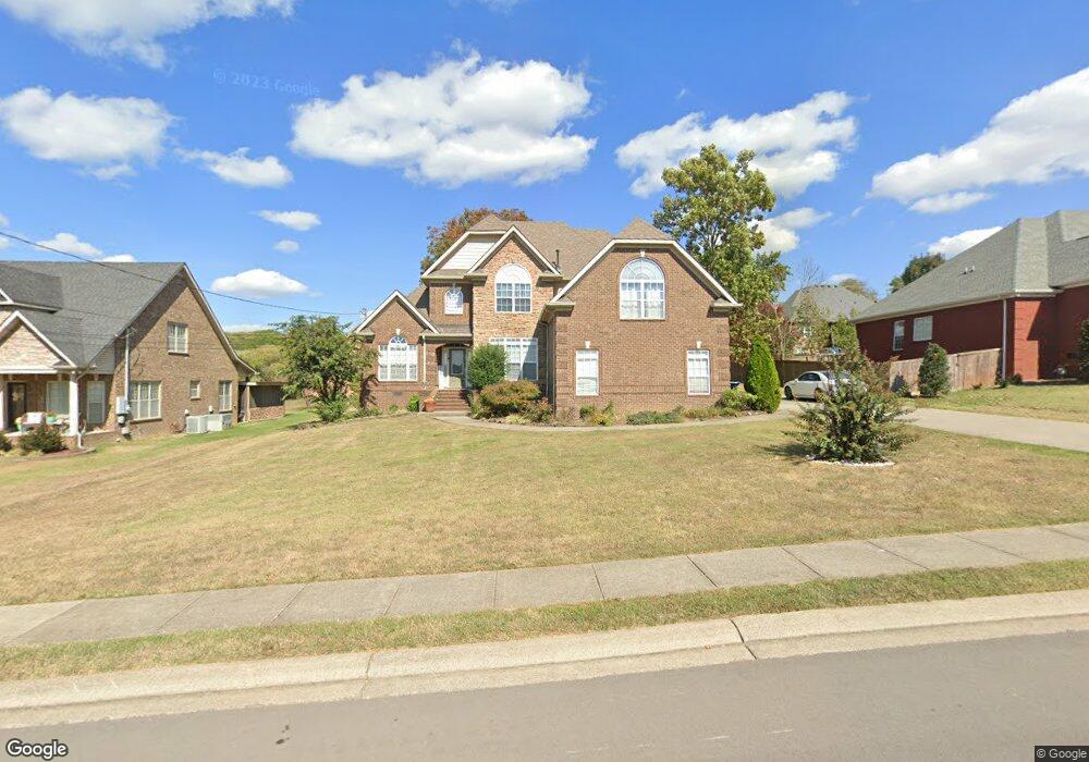
2005 Emma Kate Ct La Vergne, TN 37086
Estimated Value: $593,011 - $618,000
--
Bed
--
Bath
3,021
Sq Ft
$200/Sq Ft
Est. Value
About This Home
This home is located at 2005 Emma Kate Ct, La Vergne, TN 37086 and is currently estimated at $604,753, approximately $200 per square foot. 2005 Emma Kate Ct is a home located in Rutherford County with nearby schools including Rock Springs Elementary School, Rock Springs Middle School, and Stewarts Creek High School.
Ownership History
Date
Name
Owned For
Owner Type
Purchase Details
Closed on
May 23, 2013
Sold by
Watson Cory Jennifer
Bought by
Moore Teresa L
Current Estimated Value
Home Financials for this Owner
Home Financials are based on the most recent Mortgage that was taken out on this home.
Original Mortgage
$188,700
Outstanding Balance
$133,414
Interest Rate
3.43%
Mortgage Type
Commercial
Estimated Equity
$471,339
Purchase Details
Closed on
Dec 4, 2009
Sold by
Bledsoe James A
Bought by
Watson Cory
Home Financials for this Owner
Home Financials are based on the most recent Mortgage that was taken out on this home.
Original Mortgage
$283,882
Interest Rate
5.01%
Create a Home Valuation Report for This Property
The Home Valuation Report is an in-depth analysis detailing your home's value as well as a comparison with similar homes in the area
Home Values in the Area
Average Home Value in this Area
Purchase History
| Date | Buyer | Sale Price | Title Company |
|---|---|---|---|
| Moore Teresa L | $299,912 | -- | |
| Watson Cory | $299,900 | -- |
Source: Public Records
Mortgage History
| Date | Status | Borrower | Loan Amount |
|---|---|---|---|
| Open | Moore Teresa L | $188,700 | |
| Previous Owner | Watson Cory | $283,882 |
Source: Public Records
Tax History Compared to Growth
Tax History
| Year | Tax Paid | Tax Assessment Tax Assessment Total Assessment is a certain percentage of the fair market value that is determined by local assessors to be the total taxable value of land and additions on the property. | Land | Improvement |
|---|---|---|---|---|
| 2025 | $3,148 | $130,475 | $16,250 | $114,225 |
| 2024 | $3,148 | $130,475 | $16,250 | $114,225 |
| 2023 | $2,448 | $130,475 | $16,250 | $114,225 |
| 2022 | $2,109 | $130,475 | $16,250 | $114,225 |
| 2021 | $2,218 | $99,950 | $16,250 | $83,700 |
| 2020 | $2,218 | $99,950 | $16,250 | $83,700 |
| 2019 | $2,218 | $99,950 | $16,250 | $83,700 |
Source: Public Records
Map
Nearby Homes
- 1011 Lily Ann Ct
- 8039 Burntwood Dr
- 9005 Phoenix Ct
- 8054 Vineyard Ln
- STONEBROOK II Plan at Pottsview
- MILFORD A Plan at Pottsview
- HAYDEN Plan at Pottsview
- SALEM Plan at Pottsview
- 11012 Sligo Ct
- 5024 Mary Ellen Cir
- 114 Portico Place
- 120 Portico Place
- 120 Portico Place
- 106 Portico Place
- 262 Cornice Dr
- 261 Cornice Dr
- 269 Cornice Dr
- 6009 Inglenook Dr
- 323 Casita Dr
- 211 Cornice Dr
- 2001 Emma Kate Ct
- 2009 Emma Kate Ct
- 6494 John Sams Ct
- 8034 Vineyard Ln
- 2013 Emma Kate Ct
- 2004 Emma Kate Ct
- 2004 Emma Kate Ct
- 6498 John Sams Ct
- 2008 Emma Kate Ct
- 2000 Emma Kate Ct
- 8033 Vineyard Ln
- 8031 Vineyard Ln
- 2012 Emma Kate Ct
- 6590 John Sams Ct
- 8035 Vineyard Ln
- 2017 Emma Kate Ct
- 8029 Vineyard Ln
- 4001 Cherish Hope Ct
- 8038 Vineyard Ln
- 1003 Lily Ann Ct