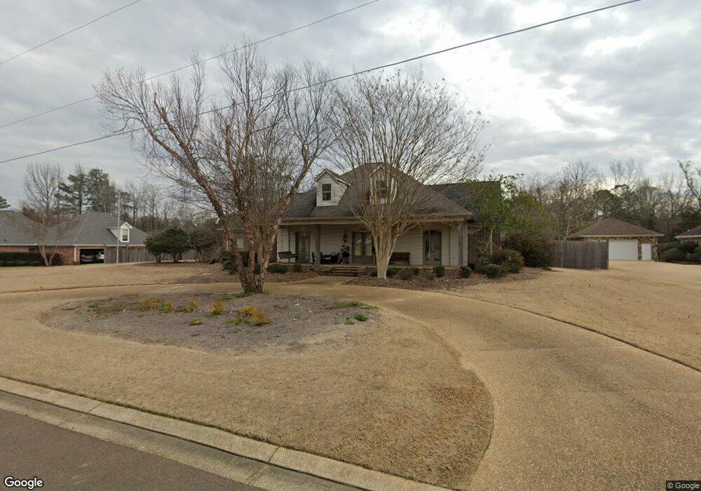
2006 Bradford Place Flowood, MS 39232
Estimated Value: $441,000 - $556,000
3
Beds
2
Baths
3,193
Sq Ft
$153/Sq Ft
Est. Value
About This Home
This home is located at 2006 Bradford Place, Flowood, MS 39232 and is currently estimated at $488,280, approximately $152 per square foot. 2006 Bradford Place is a home located in Rankin County with nearby schools including Flowood Elementary School, Northwest Rankin Middle School, and Northwest Rankin High School.
Ownership History
Date
Name
Owned For
Owner Type
Purchase Details
Closed on
Apr 19, 2024
Sold by
Roby Mary E
Bought by
Clark Ronald K and Clark Ashley B
Current Estimated Value
Purchase Details
Closed on
Aug 2, 2023
Sold by
Ellen Myers Family Living Trust
Bought by
Clark Mary Ellen
Purchase Details
Closed on
Jan 11, 2018
Sold by
Roby Mary E
Bought by
Roby Mary E
Create a Home Valuation Report for This Property
The Home Valuation Report is an in-depth analysis detailing your home's value as well as a comparison with similar homes in the area
Home Values in the Area
Average Home Value in this Area
Purchase History
| Date | Buyer | Sale Price | Title Company |
|---|---|---|---|
| Clark Ronald K | -- | None Listed On Document | |
| Clark Mary Ellen | -- | None Listed On Document | |
| Clark Mary Ellen | -- | None Listed On Document | |
| Roby Mary E | -- | None Available |
Source: Public Records
Tax History Compared to Growth
Tax History
| Year | Tax Paid | Tax Assessment Tax Assessment Total Assessment is a certain percentage of the fair market value that is determined by local assessors to be the total taxable value of land and additions on the property. | Land | Improvement |
|---|---|---|---|---|
| 2024 | $3,770 | $34,629 | $0 | $0 |
| 2023 | $2,587 | $33,265 | $0 | $0 |
| 2022 | $2,554 | $33,265 | $0 | $0 |
| 2021 | $2,554 | $33,265 | $0 | $0 |
| 2020 | $2,554 | $33,265 | $0 | $0 |
| 2019 | $2,615 | $29,512 | $0 | $0 |
| 2018 | $2,571 | $29,512 | $0 | $0 |
| 2017 | $2,571 | $29,512 | $0 | $0 |
| 2016 | $2,516 | $30,006 | $0 | $0 |
| 2015 | $2,516 | $30,006 | $0 | $0 |
| 2014 | $2,468 | $30,006 | $0 | $0 |
| 2013 | -- | $30,006 | $0 | $0 |
Source: Public Records
Map
Nearby Homes
- 505 Harper Cove
- 103 Ridgetop Cir
- 100 Redbud Ct
- 188 Webb Ln
- 120 Poplar Ridge Dr
- 201 Bronson Bend
- 221 Bronson Bend
- 229 Bronson Bend
- 183 Bronson Bend
- 218 Bronson Bend
- 195 Bronson Bend
- 191 Bronson Bend
- 125 Bronson Bend
- 199 Bronson Bend
- 179 Bronson Bend
- 159 Bronson Bend
- 169 Bronson Bend
- 167 Bronson Bend
- 141 Bronson Bend
- 181 Bronson Bend
- 2008 Bradford Place
- 2004 Bradford Place
- 10 Bradford Place Unit 10
- 10 Bradford Place
- 0 Bradford Place Unit Lot 10
- 2005 Bradford Place
- 2010 Bradford Place
- 2003 Bradford Place
- 2007 Bradford Place
- 2002 Bradford Place
- 2009 Bradford Place
- 6242 Wirtz Rd
- 2001 Bradford Place
- 102 Britton Cir
- 1 Britton Cir
- 37 Britton Cir
- 61 Britton Cir
- 174 Britton Cir
- 172 Britton Cir
- 104 Britton Cir