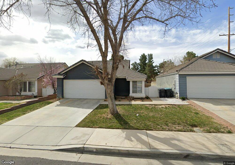
2006 Cape Cod Ln Palmdale, CA 93550
East Palmdale NeighborhoodEstimated Value: $404,331 - $462,000
3
Beds
2
Baths
1,482
Sq Ft
$292/Sq Ft
Est. Value
About This Home
This home is located at 2006 Cape Cod Ln, Palmdale, CA 93550 and is currently estimated at $432,583, approximately $291 per square foot. 2006 Cape Cod Ln is a home located in Los Angeles County with nearby schools including Desert Rose Elementary School, Cactus Magnet Academy, and Palmdale High School.
Ownership History
Date
Name
Owned For
Owner Type
Purchase Details
Closed on
Oct 1, 2018
Sold by
Stearns Philip W
Bought by
Stearns Philip Waldo and The Stearns Family Trust
Current Estimated Value
Purchase Details
Closed on
Jun 20, 2005
Sold by
Stearns Philip Waldo and Stearns Mary L
Bought by
Stearns Philip Waldo
Purchase Details
Closed on
Apr 18, 2003
Sold by
Stearns Philip Waldo and Stearns Mary Lou
Bought by
Stearns Philip Waldo
Home Financials for this Owner
Home Financials are based on the most recent Mortgage that was taken out on this home.
Original Mortgage
$125,000
Interest Rate
5.72%
Create a Home Valuation Report for This Property
The Home Valuation Report is an in-depth analysis detailing your home's value as well as a comparison with similar homes in the area
Home Values in the Area
Average Home Value in this Area
Purchase History
| Date | Buyer | Sale Price | Title Company |
|---|---|---|---|
| Stearns Philip Waldo | -- | Western Resources Title | |
| Stearns Philip W | -- | Western Resources Title Comp | |
| Stearns Philip Waldo | -- | -- | |
| Stearns Philip Waldo | -- | Fidelity National Title |
Source: Public Records
Mortgage History
| Date | Status | Borrower | Loan Amount |
|---|---|---|---|
| Previous Owner | Stearns Philip Waldo | $125,000 |
Source: Public Records
Tax History
| Year | Tax Paid | Tax Assessment Tax Assessment Total Assessment is a certain percentage of the fair market value that is determined by local assessors to be the total taxable value of land and additions on the property. | Land | Improvement |
|---|---|---|---|---|
| 2025 | $3,356 | $195,200 | $38,264 | $156,936 |
| 2024 | $3,356 | $191,373 | $37,514 | $153,859 |
| 2023 | $3,333 | $187,622 | $36,779 | $150,843 |
| 2022 | $3,210 | $183,944 | $36,058 | $147,886 |
| 2021 | $3,143 | $180,338 | $35,351 | $144,987 |
| 2019 | $3,055 | $174,991 | $34,303 | $140,688 |
| 2018 | $3,011 | $171,561 | $33,631 | $137,930 |
| 2017 | $2,976 | $168,198 | $32,972 | $135,226 |
| 2016 | $2,815 | $164,901 | $32,326 | $132,575 |
| 2015 | $2,794 | $162,425 | $31,841 | $130,584 |
| 2014 | $2,701 | $153,900 | $30,100 | $123,800 |
Source: Public Records
Map
Nearby Homes
- 37719 Nantucket Dr
- 37733 Harvey St
- 37744 Harvey St
- 2126 Mark Ave
- 37832 Halifax St
- 37730 Scomar St
- 37901 Rosemarie St
- 1703 E Avenue r3
- 1631 Roseglen Place
- 37863 17th St E
- 2309 Gregory Ave
- 5 st E Avenue R
- 1618 Roseglen Place
- 37441 Mayfield Ct
- 37422 Cambridge Ln
- 37443 Yorkshire Dr
- 37623 Robin Ln
- 2123 E Avenue r12
- 1750 E Avenue q14 Unit 10
- 1750 E Avenue q14
- 2012 Cape Cod Ln
- 2002 Cape Cod Ln
- 2016 Cape Cod Ln
- 2013 Cedarbrook Ave
- 2022 Cape Cod Ln
- 2019 Cedarbrook Ave
- 37702 Nantucket Dr
- 2026 Cape Cod Ln
- 37732 Birch Tree Ln
- 2025 Cedarbrook Ave
- 37706 Nantucket Dr
- 37713 Nantucket Dr
- 37652 Cherry Dr
- 37738 Birch Tree Ln
- 2032 Cape Cod Ln
- 1945 E Avenue r6
- 37645 Millbrook Ln
- 37710 Nantucket Dr
- 2027 Cape Cod Ln
- 2033 Cedarbrook Ave
Your Personal Tour Guide
Ask me questions while you tour the home.