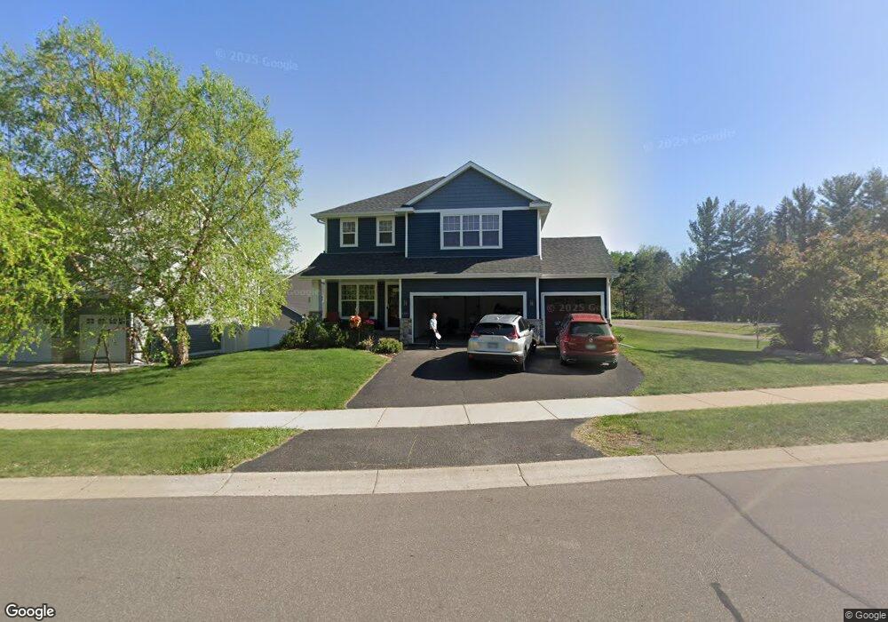
2007 Langston Ln NE Saint Michael, MN 55376
Estimated Value: $471,254 - $526,000
4
Beds
3
Baths
2,677
Sq Ft
$189/Sq Ft
Est. Value
About This Home
This home is located at 2007 Langston Ln NE, Saint Michael, MN 55376 and is currently estimated at $505,564, approximately $188 per square foot. 2007 Langston Ln NE is a home located in Wright County with nearby schools including St. Michael Elementary School, Albertville Primary School, and Middle School East.
Ownership History
Date
Name
Owned For
Owner Type
Purchase Details
Closed on
May 16, 2016
Sold by
Markus Homes Llc
Bought by
Martin Anya and Martin Gary B
Current Estimated Value
Purchase Details
Closed on
Feb 5, 2016
Purchase Details
Closed on
Mar 27, 2006
Sold by
Oakland Construction Co
Bought by
Luchsinger Fred and Luchsinger Suzanne
Purchase Details
Closed on
Sep 24, 2003
Sold by
Brightkeys Dev Corp
Bought by
Oakland Construction Company
Create a Home Valuation Report for This Property
The Home Valuation Report is an in-depth analysis detailing your home's value as well as a comparison with similar homes in the area
Home Values in the Area
Average Home Value in this Area
Purchase History
| Date | Buyer | Sale Price | Title Company |
|---|---|---|---|
| Martin Anya | $296,500 | Trademark Title Services Inc | |
| -- | $191,400 | -- | |
| Markus Homes Llc | $191,352 | Trademark Title Services Inc | |
| Luchsinger Fred | $346,000 | -- | |
| Oakland Construction Company | $123,200 | -- |
Source: Public Records
Tax History
| Year | Tax Paid | Tax Assessment Tax Assessment Total Assessment is a certain percentage of the fair market value that is determined by local assessors to be the total taxable value of land and additions on the property. | Land | Improvement |
|---|---|---|---|---|
| 2025 | $5,366 | $473,800 | $100,000 | $373,800 |
| 2024 | $5,224 | $471,100 | $95,000 | $376,100 |
| 2023 | $5,186 | $493,000 | $98,300 | $394,700 |
| 2022 | $4,782 | $453,100 | $91,000 | $362,100 |
| 2021 | $4,904 | $358,400 | $65,000 | $293,400 |
| 2020 | $4,776 | $355,500 | $65,000 | $290,500 |
| 2019 | $4,672 | $339,000 | $0 | $0 |
| 2018 | $4,308 | $319,800 | $0 | $0 |
| 2017 | $3,868 | $302,800 | $0 | $0 |
| 2016 | $3,708 | $0 | $0 | $0 |
| 2015 | $3,658 | $0 | $0 | $0 |
| 2014 | -- | $0 | $0 | $0 |
Source: Public Records
Map
Nearby Homes
- 11470 19th St NE
- 11500 19th St NE
- 11528 19th St NE
- 2130 Langston Ln NE
- 2075 Langston Ln NE
- 11559 19th St NE
- 11590 19th St NE
- 11626 19th St NE
- 2210 Lancaster Ave NE
- 1986 Laquey Ave NE
- 2274 Langston Ct NE
- 11419 17th St NE
- 1692 Langston Ave NE
- 1690 Langston Ave NE
- 1687 Langston NE
- 1689 Langston Ave NE
- 1798 Laquey Ave NE
- 1688 Langston NE
- 11618 16th Cir NE
- 11614 16th NE
- 2015 Langston Ln NE
- 11455 20th St NE
- 2008 Langston Ln NE
- 2016 Langston Ln NE
- 2000 Langston Ln NE
- 2022 Langston Ln NE
- 11461 20th St NE
- 11470 20th St NE
- 11450 20th St NE
- 11473 20th St NE
- 2030 Langston Ln NE
- 11489 20th St NE
- 11496 20th St NE
- 1985 Lander Ave NE
- 2036 Langston Ln NE
- 2104 Langston Ln NE
- 2124 Langston Ln NE
- 11501 20th St NE
- 2102 Langston Ln NE
- 11514 20th St NE
Your Personal Tour Guide
Ask me questions while you tour the home.