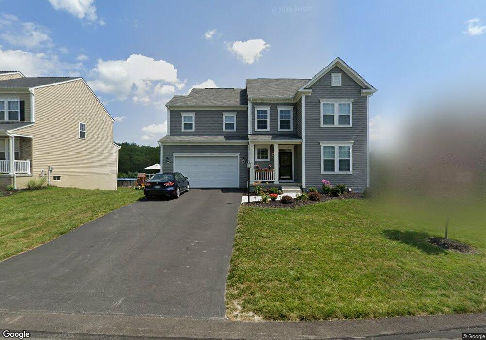
2008 Sir Patrick Dr Mc Donald, PA 15057
Estimated Value: $562,000 - $625,000
4
Beds
3
Baths
3,284
Sq Ft
$181/Sq Ft
Est. Value
About This Home
This home is located at 2008 Sir Patrick Dr, Mc Donald, PA 15057 and is currently estimated at $595,068, approximately $181 per square foot. 2008 Sir Patrick Dr is a home with nearby schools including Canon-Mcmillan Senior High School.
Ownership History
Date
Name
Owned For
Owner Type
Purchase Details
Closed on
Jun 27, 2022
Sold by
Windsor Woods Llc
Bought by
Windsor Woods Master Association
Current Estimated Value
Purchase Details
Closed on
Feb 19, 2018
Sold by
Dan Ryan Builders Mid Atlantic Llc
Bought by
Compeggie Keith L and Compeggie Jamie J
Home Financials for this Owner
Home Financials are based on the most recent Mortgage that was taken out on this home.
Original Mortgage
$327,000
Interest Rate
3.99%
Mortgage Type
New Conventional
Purchase Details
Closed on
May 9, 2017
Sold by
Windsor Woods Llc A Pennsylvania Limited
Bought by
Dan Ryan Builders Mid Atlantic Llc A Mar and Ryan Dan Bldr Mid Atlantic Llc
Create a Home Valuation Report for This Property
The Home Valuation Report is an in-depth analysis detailing your home's value as well as a comparison with similar homes in the area
Home Values in the Area
Average Home Value in this Area
Purchase History
| Date | Buyer | Sale Price | Title Company |
|---|---|---|---|
| Windsor Woods Master Association | -- | None Listed On Document | |
| Compeggie Keith L | $408,939 | None Available | |
| Dan Ryan Builders Mid Atlantic Llc A Mar | $1,008,000 | Attorney |
Source: Public Records
Mortgage History
| Date | Status | Borrower | Loan Amount |
|---|---|---|---|
| Previous Owner | Compeggie Keith L | $327,000 |
Source: Public Records
Tax History Compared to Growth
Tax History
| Year | Tax Paid | Tax Assessment Tax Assessment Total Assessment is a certain percentage of the fair market value that is determined by local assessors to be the total taxable value of land and additions on the property. | Land | Improvement |
|---|---|---|---|---|
| 2025 | $6,935 | $411,800 | $61,800 | $350,000 |
| 2024 | $6,560 | $411,800 | $61,800 | $350,000 |
| 2023 | $6,560 | $411,800 | $61,800 | $350,000 |
| 2022 | $6,541 | $411,800 | $61,800 | $350,000 |
| 2021 | $6,471 | $411,800 | $61,800 | $350,000 |
| 2020 | $6,347 | $407,400 | $61,800 | $345,600 |
| 2019 | $6,246 | $407,400 | $61,800 | $345,600 |
| 2018 | $928 | $407,400 | $61,800 | $345,600 |
| 2017 | $0 | $61,800 | $61,800 | $0 |
| 2016 | $0 | $0 | $0 | $0 |
Source: Public Records
Map
Nearby Homes
- 416 Coleman Rd
- 3294 Millers Run Rd
- 24 - 25 Millers Run Rd
- 540 Coleman Rd
- 21 Timbercrest Cir
- Lot 2 Starcrest Dr
- 29 Creedmore Rd
- Lot 8 Timbercrest Cir
- 435 Dogwood Ln
- 11 Crestwood Dr
- 8 Leasure Way
- 59 Ridgewood Dr
- Lot 18 Ridgewood Dr
- LOT 10-7-6-5 Windcrest Dr
- LOT 7 Windcrest Dr
- LOT 6 Windcrest Dr
- LOT 10 Windcrest Dr
- LOT 5 Windcrest Dr
- 804 Redwood Dr
- 20 Ridgewood Dr
- 2010 Sir Patrick Dr
- 2006 Sir Patrick Dr
- 2004 Sir Patrick Dr
- 2025 Sir Patrick Dr
- 2012 Sir Patrick Dr
- 2023 Sir Patrick Dr
- 1027 King Edward Dr
- 2027 Sir Patrick Dr
- 2014 Sir Patrick Dr
- 2021 Sir Patrick Dr
- 2029 Sir Patrick Dr
- 1028 King Edward Dr
- 2016 Sir Patrick Dr
- 1030 King Edward Dr
- 1025 King Edward Dr
- 2031 Sir Patrick Dr
- 1026 King Edward Dr
- 2019 Sir Patrick Dr Unit Lot450
- 1033 King Edward Dr
- 2018 Sir Patrick Dr