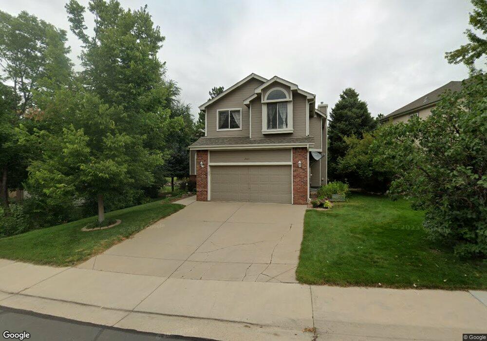
2009 Foxfield Dr Castle Rock, CO 80104
The Woodlands NeighborhoodEstimated Value: $579,000 - $654,000
3
Beds
4
Baths
1,918
Sq Ft
$321/Sq Ft
Est. Value
About This Home
This home is located at 2009 Foxfield Dr, Castle Rock, CO 80104 and is currently estimated at $616,568, approximately $321 per square foot. 2009 Foxfield Dr is a home located in Douglas County with nearby schools including Castle Rock Elementary School, Mesa Middle School, and Douglas County High School.
Ownership History
Date
Name
Owned For
Owner Type
Purchase Details
Closed on
Oct 23, 2001
Sold by
Lenz Duane E and Lenz Jane M
Bought by
Grossart Tamara L
Current Estimated Value
Home Financials for this Owner
Home Financials are based on the most recent Mortgage that was taken out on this home.
Original Mortgage
$165,000
Outstanding Balance
$64,351
Interest Rate
6.84%
Estimated Equity
$552,217
Purchase Details
Closed on
Mar 22, 1991
Sold by
Woodland C F Properties Inc
Bought by
Lenz Duane E and Lenz Jane M
Purchase Details
Closed on
Mar 28, 1989
Sold by
Commercial Fed Sav & Loan Assoc
Bought by
C F Woodland Properties Inc
Purchase Details
Closed on
Jan 26, 1987
Sold by
Talley Corporation
Bought by
Empire Savings Building & Loan Associati
Create a Home Valuation Report for This Property
The Home Valuation Report is an in-depth analysis detailing your home's value as well as a comparison with similar homes in the area
Home Values in the Area
Average Home Value in this Area
Purchase History
| Date | Buyer | Sale Price | Title Company |
|---|---|---|---|
| Grossart Tamara L | $220,000 | Land Title | |
| Lenz Duane E | $118,500 | -- | |
| C F Woodland Properties Inc | -- | -- | |
| Empire Savings Building & Loan Associati | -- | -- |
Source: Public Records
Mortgage History
| Date | Status | Borrower | Loan Amount |
|---|---|---|---|
| Open | Grossart Tamara L | $165,000 |
Source: Public Records
Tax History Compared to Growth
Tax History
| Year | Tax Paid | Tax Assessment Tax Assessment Total Assessment is a certain percentage of the fair market value that is determined by local assessors to be the total taxable value of land and additions on the property. | Land | Improvement |
|---|---|---|---|---|
| 2024 | $2,546 | $40,440 | $9,450 | $30,990 |
| 2023 | $2,582 | $40,440 | $9,450 | $30,990 |
| 2022 | $1,825 | $27,390 | $6,900 | $20,490 |
| 2021 | $1,905 | $27,390 | $6,900 | $20,490 |
| 2020 | $2,222 | $27,560 | $6,460 | $21,100 |
| 2019 | $2,319 | $27,560 | $6,460 | $21,100 |
| 2018 | $2,073 | $24,130 | $4,970 | $19,160 |
| 2017 | $1,930 | $24,130 | $4,970 | $19,160 |
| 2016 | $1,803 | $22,070 | $4,730 | $17,340 |
| 2015 | $922 | $22,070 | $4,730 | $17,340 |
| 2014 | $1,641 | $18,180 | $4,580 | $13,600 |
Source: Public Records
Map
Nearby Homes
- 2596 Saddleback Dr
- 2111 Ramblewood Ct
- 1992 Woodbourne Terrace
- 2369 Bayberry Ln
- 2554 Saddleback Dr
- 993 Pleasant View St
- 1387 Fox Canyon Ln
- 1008 Park View Ct
- 2696 Castle Crest Dr
- 3455 Falling Star Place
- 2208 Paint Pony Cir
- 3495 Amber Sun Cir
- 797 Canyon Dr Unit 797
- 3469 Amber Sun Cir
- 767 Canyon Dr Unit 767
- 1044 N Bader Ct
- 3278 Ghost Dance Dr
- 19 Rock Ln
- 3520 Desert Ridge Cir
- 3195 Arroyo Verde Way
- 1989 Foxfield Dr
- 2039 Foxfield Dr
- 1973 Foxfield Dr
- 2059 Foxfield Dr
- 1948 Foxfield Dr
- 1934 Foxfield Dr
- 2036 Saddleback Dr
- 2046 Foxfield Dr
- 1957 Foxfield Dr
- 2089 Foxfield Dr
- 1962 Foxfield Dr
- 1918 Foxfield Dr
- 2032 Saddleback Dr
- 2066 Foxfield Dr
- 1941 Foxfield Dr
- 2026 Foxfield Dr
- 2086 Foxfield Dr
- 2016 Saddleback Dr
- 1984 Foxfield Dr
- 1925 Foxfield Dr