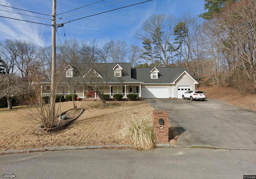
2009 Port Royal Dr Soddy Daisy, TN 37379
Estimated Value: $467,000 - $613,000
3
Beds
5
Baths
3,052
Sq Ft
$171/Sq Ft
Est. Value
About This Home
This home is located at 2009 Port Royal Dr, Soddy Daisy, TN 37379 and is currently estimated at $523,008, approximately $171 per square foot. 2009 Port Royal Dr is a home located in Hamilton County with nearby schools including McConnell Elementary School and Loftis Middle School.
Ownership History
Date
Name
Owned For
Owner Type
Purchase Details
Closed on
Nov 30, 1998
Sold by
Daniel Eddie J and Daniel Virginia F
Bought by
Bean Donald Alan and Bean Bonnie Glenn
Current Estimated Value
Home Financials for this Owner
Home Financials are based on the most recent Mortgage that was taken out on this home.
Original Mortgage
$95,000
Outstanding Balance
$21,560
Interest Rate
6.77%
Estimated Equity
$501,448
Purchase Details
Closed on
Sep 20, 1995
Bought by
Daniel Eddie J and Daniel Virginia
Create a Home Valuation Report for This Property
The Home Valuation Report is an in-depth analysis detailing your home's value as well as a comparison with similar homes in the area
Home Values in the Area
Average Home Value in this Area
Purchase History
| Date | Buyer | Sale Price | Title Company |
|---|---|---|---|
| Bean Donald Alan | $175,000 | Legal Title & Escrow Inc | |
| Daniel Eddie J | $20,000 | -- |
Source: Public Records
Mortgage History
| Date | Status | Borrower | Loan Amount |
|---|---|---|---|
| Open | Bean Donald Alan | $95,000 |
Source: Public Records
Tax History Compared to Growth
Tax History
| Year | Tax Paid | Tax Assessment Tax Assessment Total Assessment is a certain percentage of the fair market value that is determined by local assessors to be the total taxable value of land and additions on the property. | Land | Improvement |
|---|---|---|---|---|
| 2024 | $1,894 | $84,650 | $0 | $0 |
| 2023 | $1,903 | $84,650 | $0 | $0 |
| 2022 | $1,903 | $84,650 | $0 | $0 |
| 2021 | $1,903 | $84,650 | $0 | $0 |
| 2020 | $1,923 | $69,200 | $0 | $0 |
| 2019 | $1,923 | $69,200 | $0 | $0 |
| 2018 | $1,923 | $69,200 | $0 | $0 |
| 2017 | $1,923 | $69,200 | $0 | $0 |
| 2016 | $1,715 | $0 | $0 | $0 |
| 2015 | $1,715 | $61,700 | $0 | $0 |
| 2014 | $1,715 | $0 | $0 | $0 |
Source: Public Records
Map
Nearby Homes
- 1915 Port Royal Dr
- 2028 Port Royal Dr
- 2107 Port Royal Dr
- 8900 Wellthor Cir
- 2125 Port Royal Dr
- 2119 Collins Ln
- 2221 Chimney Hills Dr
- 1988 Warwickshire Dr
- 0 Warwickshire Dr
- 2316 Lakesite Dr
- 2207 Driftwood Rd
- 11111 Hixson Pike
- 1814 Dallas Lake Rd
- 1806 Dallas Lake Rd
- 8901 Dalton Ln
- 2109 Millard Rd
- 1818 Millard Rd
- 2031 Millard Rd
- 9416 Thrasher Trail
- 2548 Chimney Lake Cir
- 2001 Port Royal Dr
- 2048 Dallas Lake Rd
- 2100 Dallas Lake Rd
- 1923 Port Royal Dr
- 2000 Port Royal Dr
- 2000 Port Royal Dr Unit 342
- 2044 Dallas Lake Rd
- 2104 Dallas Lake Rd
- 1924 Port Royal Dr
- 1924 Port Royal Dr Unit 342
- 1921 Port Royal Dr
- 9038 Chip Dr
- 2015 Port Royal Dr
- 2040 Dallas Lake Rd
- 9034 Chip Dr
- 1922 Port Royal Dr
- 2106 Dallas Lake Rd
- 2103 Dallas Lake Rd
- 2020 Port Royal Dr
- 2020 Port Royal Dr Unit 241