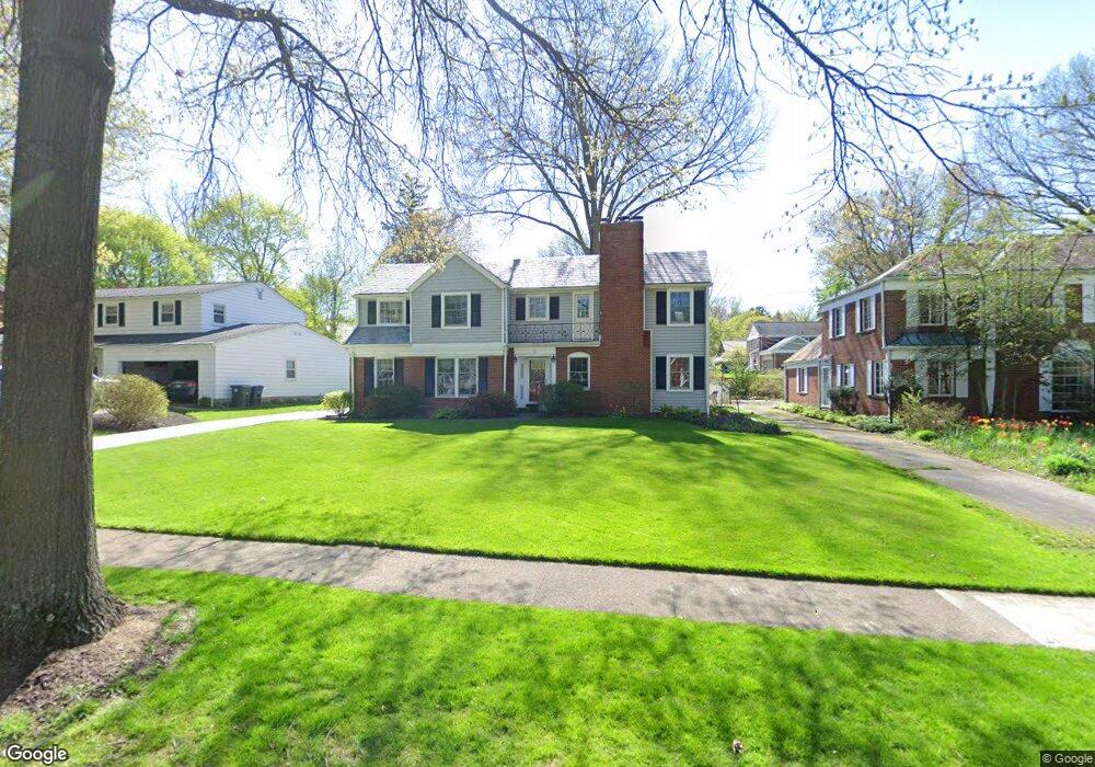
201 Dorchester Rd Akron, OH 44313
West Akron NeighborhoodEstimated Value: $294,588 - $357,000
4
Beds
3
Baths
2,447
Sq Ft
$132/Sq Ft
Est. Value
About This Home
This home is located at 201 Dorchester Rd, Akron, OH 44313 and is currently estimated at $322,397, approximately $131 per square foot. 201 Dorchester Rd is a home located in Summit County with nearby schools including Summit Academy School, Our Lady Of The Elms Elementary School, and Julie Billiart School Akron.
Ownership History
Date
Name
Owned For
Owner Type
Purchase Details
Closed on
Sep 14, 2000
Sold by
Lobello Vincent J J and Lobello Virginia M
Bought by
Mclaughlin John E and Mclaughlin Jill C
Current Estimated Value
Home Financials for this Owner
Home Financials are based on the most recent Mortgage that was taken out on this home.
Original Mortgage
$120,000
Interest Rate
8.14%
Create a Home Valuation Report for This Property
The Home Valuation Report is an in-depth analysis detailing your home's value as well as a comparison with similar homes in the area
Home Values in the Area
Average Home Value in this Area
Purchase History
| Date | Buyer | Sale Price | Title Company |
|---|---|---|---|
| Mclaughlin John E | $200,000 | Exchange Place Title Agency |
Source: Public Records
Mortgage History
| Date | Status | Borrower | Loan Amount |
|---|---|---|---|
| Closed | Mclaughlin John E | $120,000 |
Source: Public Records
Tax History
| Year | Tax Paid | Tax Assessment Tax Assessment Total Assessment is a certain percentage of the fair market value that is determined by local assessors to be the total taxable value of land and additions on the property. | Land | Improvement |
|---|---|---|---|---|
| 2024 | $4,617 | $87,010 | $16,814 | $70,196 |
| 2023 | $4,617 | $87,010 | $16,814 | $70,196 |
| 2022 | $4,732 | $70,168 | $13,559 | $56,609 |
| 2021 | $4,737 | $70,168 | $13,559 | $56,609 |
| 2020 | $4,665 | $70,170 | $13,560 | $56,610 |
| 2019 | $5,001 | $68,510 | $13,560 | $54,950 |
| 2018 | $4,933 | $68,510 | $13,560 | $54,950 |
| 2017 | $4,513 | $68,510 | $13,560 | $54,950 |
| 2016 | $4,516 | $61,450 | $13,560 | $47,890 |
| 2015 | $4,513 | $61,450 | $13,560 | $47,890 |
| 2014 | $4,477 | $61,450 | $13,560 | $47,890 |
| 2013 | $4,388 | $61,500 | $13,560 | $47,940 |
Source: Public Records
Map
Nearby Homes
- 141 Storer Ave
- 423 S Rose Blvd
- 1153 Sunset View Dr
- 166 Marvin Ave
- 931 Amelia Ave
- S/L 12 W Sunrise View Dr
- 426 Dorchester Rd
- 138 Marvin Ave
- 985 Bloomfield Ave
- 101 Marvin Ave
- 286 Alhambra Way
- S/L 39 W Sunset View Dr
- S/L 37 W Sunset View Dr
- S/L 38 W Sunset View Dr
- S/L 40 W Sunset View Dr
- 1021 Delia Ave
- 115 Grandin Rd
- 1007 Delia Ave
- 42 Gloucester Ct Unit 3A
- 25 Berkshire Ct Unit 3A
- 195 Dorchester Rd
- 209 Dorchester Rd
- 187 Dorchester Rd
- 217 Dorchester Rd
- 286 S Rose Blvd
- 200 Dorchester Rd
- 294 S Rose Blvd
- 218 Dorchester Rd
- 276 S Rose Blvd
- 225 Dorchester Rd
- 179 Dorchester Rd
- 300 S Rose Blvd
- 314 Afton Ave
- 233 Dorchester Rd
- 169 Dorchester Rd
- 230 Dorchester Rd
- 295 Afton Ave
- 320 Afton Ave
- 275 Afton Ave
- 254 S Rose Blvd
Your Personal Tour Guide
Ask me questions while you tour the home.