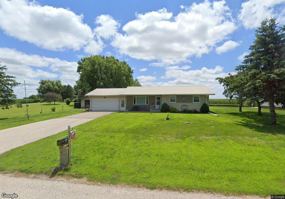
201 E 8th St Pomeroy, IA 50575
Estimated Value: $105,000 - $183,000
3
Beds
2
Baths
1,096
Sq Ft
$132/Sq Ft
Est. Value
About This Home
This home is located at 201 E 8th St, Pomeroy, IA 50575 and is currently estimated at $145,002, approximately $132 per square foot. 201 E 8th St is a home located in Calhoun County with nearby schools including Pocahontas Area Elementary School and Pocahontas Area Middle School / High School.
Ownership History
Date
Name
Owned For
Owner Type
Purchase Details
Closed on
Jan 28, 2021
Sold by
Klocko Kenneth and Klocko Linda A
Bought by
Lewis James and Lewis Melissa
Current Estimated Value
Purchase Details
Closed on
Dec 24, 2015
Sold by
Larson Bill and Drury Barbara
Bought by
Mathiasen Bertilla and Kermit E Boll Trust
Purchase Details
Closed on
Nov 12, 2013
Sold by
Larson Harold E and Larson Eldora L
Bought by
Larson Bill and Drury Barbara
Create a Home Valuation Report for This Property
The Home Valuation Report is an in-depth analysis detailing your home's value as well as a comparison with similar homes in the area
Purchase History
| Date | Buyer | Sale Price | Title Company |
|---|---|---|---|
| Lewis James | $190,000 | None Available | |
| Mathiasen Bertilla | $78,500 | None Available | |
| Larson Bill | -- | None Available |
Source: Public Records
Tax History
| Year | Tax Paid | Tax Assessment Tax Assessment Total Assessment is a certain percentage of the fair market value that is determined by local assessors to be the total taxable value of land and additions on the property. | Land | Improvement |
|---|---|---|---|---|
| 2025 | $1,334 | $171,870 | $18,720 | $153,150 |
| 2024 | $1,334 | $156,830 | $15,600 | $141,230 |
| 2023 | $1,307 | $156,830 | $15,600 | $141,230 |
| 2022 | $1,506 | $114,950 | $7,660 | $107,290 |
| 2021 | $1,302 | $114,950 | $7,660 | $107,290 |
| 2020 | $1,249 | $100,570 | $6,960 | $93,610 |
| 2019 | $1,163 | $92,150 | $6,960 | $85,190 |
| 2018 | $1,162 | $92,150 | $6,960 | $85,190 |
| 2017 | $1,162 | $92,150 | $6,960 | $85,190 |
| 2016 | $1,092 | $87,130 | $0 | $0 |
| 2015 | $1,092 | $72,330 | $0 | $0 |
| 2014 | $772 | $72,330 | $0 | $0 |
Source: Public Records
Map
Nearby Homes
- 211 S Ontario St
- 8921 Twin Lakes Rd
- 5151 Lakeside Ln
- 7493 Twin Lakes Rd
- 7342 Twin Lakes Rd
- 1329 10th St
- 311 Hansen Ave
- 615 Southwood Dr
- 1608 Main St
- 14884 620th St
- 1321 Main St
- 1235 Main St
- 1119 4th Ave
- 1118 4th Ave
- 350 Main St
- TBD 160th Ave
- 504 Queen St
- 305 Franklin St
- 2115 Van Buren Ave
- Tbd 160th Ave
- 107 E 8th St
- 107 E 8th St
- 715 S Cayuga St
- 203 E 8th St
- 715 S Ontario St
- 716 S Cayuga St
- 711 S Ontario St
- 865 S Main St
- 712 S Scuyler St
- 709 S Cayuga St
- 709 S Scuyler St
- 707 S Ontario St
- 704 & 709 Cayuga St
- 704 S Cayuga St
- 701 S Cayuga St
- 703 S Ontario St
- 703 S Ontario St
- 703 S Ontario St
- 303 E 7th St
- 706 S Ontario St
Your Personal Tour Guide
Ask me questions while you tour the home.