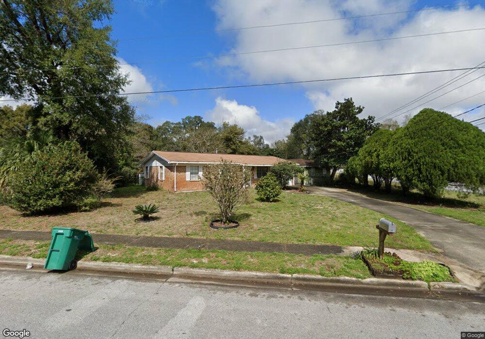
201 Hudson Cir Niceville, FL 32578
Estimated Value: $292,473 - $331,000
3
Beds
2
Baths
1,417
Sq Ft
$217/Sq Ft
Est. Value
About This Home
This home is located at 201 Hudson Cir, Niceville, FL 32578 and is currently estimated at $307,618, approximately $217 per square foot. 201 Hudson Cir is a home located in Okaloosa County with nearby schools including Lula J. Edge Elementary School, C.W. Ruckel Middle School, and Niceville Senior High School.
Ownership History
Date
Name
Owned For
Owner Type
Purchase Details
Closed on
Sep 9, 2020
Sold by
Duff Dawn Alisa and Burkhard David Alan
Bought by
Harris William F and Harris Lynette L
Current Estimated Value
Home Financials for this Owner
Home Financials are based on the most recent Mortgage that was taken out on this home.
Original Mortgage
$184,594
Outstanding Balance
$163,815
Interest Rate
2.9%
Mortgage Type
FHA
Estimated Equity
$143,803
Create a Home Valuation Report for This Property
The Home Valuation Report is an in-depth analysis detailing your home's value as well as a comparison with similar homes in the area
Home Values in the Area
Average Home Value in this Area
Purchase History
| Date | Buyer | Sale Price | Title Company |
|---|---|---|---|
| Harris William F | $192,000 | Cotton Land Title Llc |
Source: Public Records
Mortgage History
| Date | Status | Borrower | Loan Amount |
|---|---|---|---|
| Open | Harris William F | $184,594 |
Source: Public Records
Tax History Compared to Growth
Tax History
| Year | Tax Paid | Tax Assessment Tax Assessment Total Assessment is a certain percentage of the fair market value that is determined by local assessors to be the total taxable value of land and additions on the property. | Land | Improvement |
|---|---|---|---|---|
| 2024 | $2,211 | $208,875 | $67,939 | $140,936 |
| 2023 | $2,211 | $205,547 | $67,265 | $138,282 |
| 2022 | $2,350 | $194,464 | $64,062 | $130,402 |
| 2021 | $2,055 | $152,173 | $44,565 | $107,608 |
| 2020 | $813 | $99,214 | $0 | $0 |
| 2019 | $795 | $96,983 | $0 | $0 |
| 2018 | $781 | $95,175 | $0 | $0 |
| 2017 | $791 | $94,772 | $0 | $0 |
| 2016 | $768 | $92,823 | $0 | $0 |
| 2015 | $784 | $92,178 | $0 | $0 |
| 2014 | $784 | $91,446 | $0 | $0 |
Source: Public Records
Map
Nearby Homes
- 302 22nd St
- 202 22nd St
- 310 22nd St
- 1305 Finck Rd
- 203 22nd St
- 1200 Cedar Ave S
- 1417 Beaver Run Rd Unit 9
- 1117 Cedar Ave S
- 111 Beverly Dr
- 0 Bayshore Dr
- 338 Pontevedra Ln
- 817 Valparaiso Blvd
- 12 Corbin Ct
- 500 22nd St
- 1001 Bayshore Dr
- 1970 Hattie Mae Ln
- 503 22nd St
- 1000 Christy Dr
- 1958 Hattie Mae Ln
- 1111 Coral Dr