
201 Kodiak Rd Como, CO 80432
1.16
Acres
$36,207
Price per Acre
50,530
Sq Ft Lot
Highlights
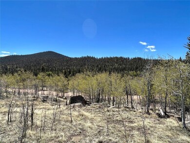
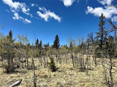
- View of Trees or Woods
- Trails
- Satellite Dish
About This Lot
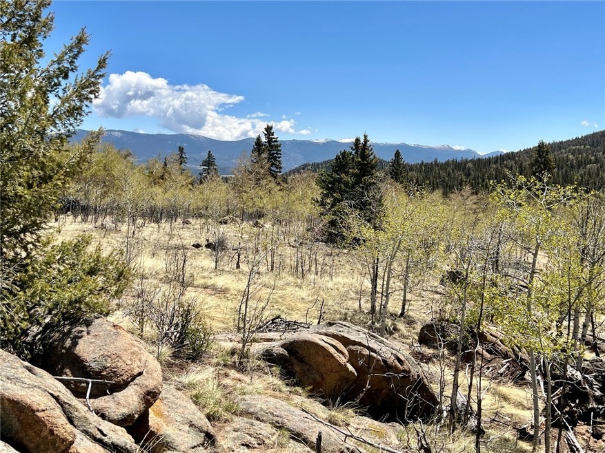
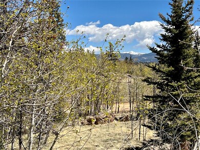
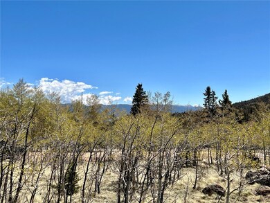
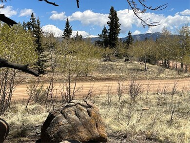
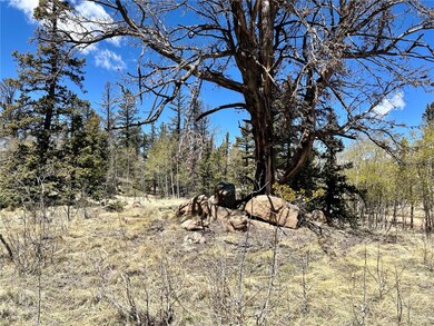
As of September 2022Panoramic Views! Privacy on 1.16 Acres! Secluded lot located in the popular Indian Mountain Subdivision. This lot has it all...rock outcropping, views, mix of healthy aspen and pines! Gentle slope offers variety of building envelopes. Convenient location to enjoy the mountain activities of fishing, hiking, camping and skiing! Close to Tarryall Reservoir & National Forest. Incredible spot to escape to tranquility!
Last Agent to Sell the Property
Caniglia Real Estate Group,LLC License #FA40047580 Listed on: 06/09/2022
Last Buyer's Agent
Agent Not In Board
NON-BOARD OFFICE
Property Details
Property Type
- Land
Est. Annual Taxes
- $261
Lot Details
- 1.16 Acre Lot
HOA Fees
- $4 Monthly HOA Fees
Property Views
- Woods
- Mountain
- Meadow
Utilities
- Propane
- Well
- Septic Needed
- Phone Available
- Satellite Dish
Listing and Financial Details
- Assessor Parcel Number 2446
Community Details
Overview
- Association fees include management
- Indian Mountain Subdivision
Recreation
- Trails
Ownership History
Date
Name
Owned For
Owner Type
Purchase Details
Listed on
Jun 9, 2022
Closed on
Sep 29, 2022
Sold by
Mcdaniel Michael
Bought by
Wyler Jennifer A
Seller's Agent
Bonnie Paffenroth
Caniglia Real Estate Group,LLC
Buyer's Agent
Agent Not In Board
NON-BOARD OFFICE
List Price
$42,000
Sold Price
$42,000
Total Days on Market
82
Current Estimated Value
Home Financials for this Owner
Home Financials are based on the most recent Mortgage that was taken out on this home.
Estimated Appreciation
$89,361
Avg. Annual Appreciation
52.08%
Purchase Details
Listed on
May 16, 2015
Closed on
Jun 10, 2015
Sold by
Miller Cordova Inc
Bought by
Mcdaniel Michael
Seller's Agent
Amy Caniglia
Caniglia Real Estate Group,LLC
Buyer's Agent
Bonnie Paffenroth
Caniglia Real Estate Group,LLC
List Price
$12,000
Sold Price
$12,000
Home Financials for this Owner
Home Financials are based on the most recent Mortgage that was taken out on this home.
Avg. Annual Appreciation
18.69%
Similar Properties in Como, CO
-
$43,400
- Land
- 1.05 Acres
- $41,333 per Acre
- 0 Kiowa St
- Unit 9633454
- Como, CO
Beautifully treed lot - over an acre of Pines & Aspens. Divide views and valley below. Gentle slope with power on the front ofthe property. The friendly community of Indian Mountain offers many amenities for residents: Frisbee golf, picnic area, RVparking, community center, and showers. County maintained roads make for easy access all year. Camp now and build when youare ready. Easy
JoAnn MacDougall Jefferson Real Estate
Create a Home Valuation Report for This Property
The Home Valuation Report is an in-depth analysis detailing your home's value as well as a comparison with similar homes in the area
Home Values in the Area
Average Home Value in this Area
Purchase History
| Date | Type | Sale Price | Title Company |
|---|---|---|---|
| Warranty Deed | $42,000 | -- | |
| Warranty Deed | $12,000 | Fidelity National Title Insu |
Source: Public Records
Property History
| Date | Event | Price | Change | Sq Ft Price |
|---|---|---|---|---|
| 09/30/2022 09/30/22 | Sold | $42,000 | 0.0% | -- |
| 08/31/2022 08/31/22 | Pending | -- | -- | -- |
| 06/09/2022 06/09/22 | For Sale | $42,000 | +250.0% | -- |
| 06/10/2015 06/10/15 | Sold | $12,000 | 0.0% | -- |
| 05/16/2015 05/16/15 | For Sale | $12,000 | -- | -- |
Source: Summit MLS
Tax History Compared to Growth
Tax History
| Year | Tax Paid | Tax Assessment Tax Assessment Total Assessment is a certain percentage of the fair market value that is determined by local assessors to be the total taxable value of land and additions on the property. | Land | Improvement |
|---|---|---|---|---|
| 2024 | $492 | $7,700 | $7,700 | $0 |
| 2023 | $492 | $8,001 | $8,001 | $0 |
| 2022 | $266 | $3,685 | $3,685 | $0 |
| 2021 | $261 | $3,685 | $3,685 | $0 |
| 2020 | $211 | $2,910 | $2,910 | $0 |
| 2019 | $206 | $2,910 | $2,910 | $0 |
| 2018 | $200 | $2,910 | $2,910 | $0 |
| 2017 | $175 | $2,780 | $2,780 | $0 |
| 2016 | $212 | $3,330 | $3,330 | $0 |
| 2015 | $216 | $3,330 | $3,330 | $0 |
| 2014 | $175 | $0 | $0 | $0 |
Source: Public Records
Agents Affiliated with this Home
-
Bonnie Paffenroth
Seller's Agent in 2022
Bonnie Paffenroth
Caniglia Real Estate Group,LLC
(970) 406-1610
119 Total Sales
-
A
Buyer's Agent in 2022
Agent Not In Board
NON-BOARD OFFICE
-
Amy Caniglia
Seller's Agent in 2015
Amy Caniglia
Caniglia Real Estate Group,LLC
(303) 870-6446
198 Total Sales
Map
Source: Summit MLS
MLS Number: S1036749
APN: 2446
Disclaimer: Certain information contained herein is derived from information provided by parties other than Homes.com. All information provided is deemed reliable, but is not guaranteed to be accurate and should be independently verified.
![]() Copyright © 2025 SAR MLS. The information displayed herein was derived from sources believed to be accurate, but has not been verified by SAR MLS. Buyers are cautioned to verify all information to their own satisfaction. This information is exclusively for viewers’ personal, non-commercial use. Any republication or reproduction of the information herein without the express permission of the SAR MLS is strictly prohibited.
Copyright © 2025 SAR MLS. The information displayed herein was derived from sources believed to be accurate, but has not been verified by SAR MLS. Buyers are cautioned to verify all information to their own satisfaction. This information is exclusively for viewers’ personal, non-commercial use. Any republication or reproduction of the information herein without the express permission of the SAR MLS is strictly prohibited.
Nearby Homes
- 1023 Chippewa Rd
- 146 Atoka Dr
- 169 Ithaca Ln
- 446 Chief Trail
- 1907 Wampum Ln
- 544 Chippewa Rd
- 1199 Chippewa Rd
- 413 Chief Trail
- 999 Bowstring
- 222 Chief Trail
- 268 Chippewa Rd
- 343 Chief Trail
- 287 & 234 Warclub Ct
- 57 Flint Ct
- 815 Nez Perce Rd
- 1836 Wampum Ln
- 355 Quiver Rd
- 437 Overland Cir
- 672 Wampum Ln
- 339 Wampum Ln