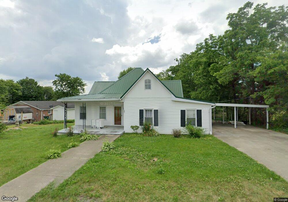
201 Locust St Mc Ewen, TN 37101
Estimated Value: $160,000 - $214,000
--
Bed
1
Bath
1,180
Sq Ft
$153/Sq Ft
Est. Value
About This Home
This home is located at 201 Locust St, Mc Ewen, TN 37101 and is currently estimated at $181,113, approximately $153 per square foot. 201 Locust St is a home located in Humphreys County with nearby schools including St. Patrick's School.
Ownership History
Date
Name
Owned For
Owner Type
Purchase Details
Closed on
Oct 25, 2022
Sold by
Wallace Peggy
Bought by
Littleton Bob
Current Estimated Value
Purchase Details
Closed on
Mar 1, 2000
Sold by
Young Marty D
Bought by
Wallace Billy W
Purchase Details
Closed on
Jan 14, 1998
Bought by
Young Marty D and Young Suzanne H
Purchase Details
Closed on
Jun 28, 1996
Bought by
Young Marty D
Purchase Details
Closed on
Sep 5, 1995
Bought by
Luff Pauline
Purchase Details
Closed on
Dec 23, 1970
Bought by
Luff Pauline
Purchase Details
Closed on
Jun 25, 1968
Create a Home Valuation Report for This Property
The Home Valuation Report is an in-depth analysis detailing your home's value as well as a comparison with similar homes in the area
Home Values in the Area
Average Home Value in this Area
Purchase History
| Date | Buyer | Sale Price | Title Company |
|---|---|---|---|
| Littleton Bob | $71,000 | -- | |
| Wallace Billy W | $57,000 | -- | |
| Young Marty D | -- | -- | |
| Young Marty D | $21,000 | -- | |
| Luff Pauline | -- | -- | |
| Luff Pauline | -- | -- | |
| -- | -- | -- |
Source: Public Records
Tax History Compared to Growth
Tax History
| Year | Tax Paid | Tax Assessment Tax Assessment Total Assessment is a certain percentage of the fair market value that is determined by local assessors to be the total taxable value of land and additions on the property. | Land | Improvement |
|---|---|---|---|---|
| 2024 | $657 | $31,275 | $5,875 | $25,400 |
| 2023 | $656 | $31,275 | $5,875 | $25,400 |
| 2022 | $519 | $20,125 | $1,650 | $18,475 |
| 2021 | $519 | $20,125 | $1,650 | $18,475 |
| 2020 | $519 | $20,125 | $1,650 | $18,475 |
| 2019 | $420 | $16,450 | $1,625 | $14,825 |
| 2018 | $413 | $16,200 | $1,625 | $14,575 |
| 2017 | $413 | $16,200 | $1,625 | $14,575 |
| 2016 | $361 | $12,975 | $1,625 | $11,350 |
| 2015 | $361 | $12,975 | $1,625 | $11,350 |
| 2014 | $361 | $12,972 | $0 | $0 |
Source: Public Records
Map
Nearby Homes
- 135 Main St
- 596 High St E
- 131 Bold Springs Rd
- 0 Ridgewood Dr Unit RTC3001972
- 0 Ridgewood Dr Unit RTC2942955
- 0 Ridgewood Dr Unit RTC2818596
- 0 Ridgewood Dr Unit RTC2791892
- 0 Ridgewood Dr Unit RTC2765366
- 0 Ridgewood Dr Unit RTC2564240
- 372 Melrose St
- 126 Mike St
- 0 Curtis Chapel Rd
- 4407 Tennessee 231
- 19 Brook St
- 0 Hilltop Dr
- 0 Trace Creek Rd
- 1280 Bold Springs Rd
- 0 Hurt Loop
- 7731 Highway 70 E
- 1990 Old Blacktop Rd