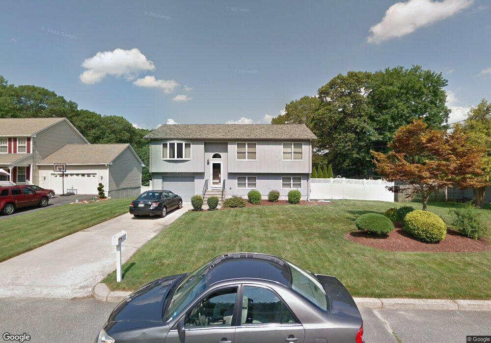
201 Mohawk Trail Cranston, RI 02921
Western Cranston NeighborhoodEstimated Value: $537,413 - $683,000
3
Beds
1
Bath
1,220
Sq Ft
$505/Sq Ft
Est. Value
About This Home
This home is located at 201 Mohawk Trail, Cranston, RI 02921 and is currently estimated at $616,603, approximately $505 per square foot. 201 Mohawk Trail is a home located in Providence County with nearby schools including Orchard Farms El. School, Hope Highlands Middle School, and Cranston High School West.
Ownership History
Date
Name
Owned For
Owner Type
Purchase Details
Closed on
Feb 22, 1993
Sold by
Boscia Ii Carmen P
Bought by
Proia Robert and Proia Donna
Current Estimated Value
Create a Home Valuation Report for This Property
The Home Valuation Report is an in-depth analysis detailing your home's value as well as a comparison with similar homes in the area
Home Values in the Area
Average Home Value in this Area
Purchase History
| Date | Buyer | Sale Price | Title Company |
|---|---|---|---|
| Proia Robert | $130,000 | -- |
Source: Public Records
Mortgage History
| Date | Status | Borrower | Loan Amount |
|---|---|---|---|
| Open | Proia Robert | $60,000 | |
| Open | Proia Robert | $115,000 | |
| Closed | Proia Robert | $50,000 | |
| Closed | Proia Robert | $25,000 |
Source: Public Records
Tax History Compared to Growth
Tax History
| Year | Tax Paid | Tax Assessment Tax Assessment Total Assessment is a certain percentage of the fair market value that is determined by local assessors to be the total taxable value of land and additions on the property. | Land | Improvement |
|---|---|---|---|---|
| 2025 | $6,561 | $472,700 | $138,400 | $334,300 |
| 2024 | $6,433 | $472,700 | $138,400 | $334,300 |
| 2023 | $5,942 | $314,400 | $99,000 | $215,400 |
| 2022 | $5,820 | $314,400 | $99,000 | $215,400 |
| 2021 | $5,659 | $314,400 | $99,000 | $215,400 |
| 2020 | $5,857 | $282,000 | $99,000 | $183,000 |
| 2019 | $5,857 | $282,000 | $99,000 | $183,000 |
| 2018 | $5,722 | $282,000 | $99,000 | $183,000 |
| 2017 | $5,946 | $259,200 | $84,900 | $174,300 |
| 2016 | $5,819 | $259,200 | $84,900 | $174,300 |
| 2015 | $5,819 | $259,200 | $84,900 | $174,300 |
| 2014 | $5,107 | $223,600 | $70,700 | $152,900 |
Source: Public Records
Map
Nearby Homes
- 80 Tomahawk Trail
- 2 Mulberry Dr
- 102 Moccasin Trail
- 10 Honey Lou Ct
- 0 Anthony Dr Unit 1394338
- 18 Quail Ridge Rd
- 121 Ashbrook Dr
- 311 Hope Rd
- 9 Gray Coach E
- 02 Paula Ln
- 01 Paula Ln
- 12 Beechwood Dr
- 3 Equestrian Ln
- 53 Charcalee Dr
- 20 Doreen Ct
- 105 Amy Dr
- 95 Amy Dr
- 1213 Phenix Ave
- 129 Valerie Ct
- 26 Scituate Farms Dr
- 197 Mohawk Trail
- 166 Canonchet Trail
- 211 Mohawk Trail
- 160 Canonchet Trail
- 202 Mohawk Trail
- 208 Mohawk Trail
- 154 Canonchet Trail
- 150 Canonchet
- 192 Mohawk Trail
- 218 Mohawk Trail
- 177 Mohawk Trail
- 165 Canonchet Trail
- 11 Agawam Trail
- 175 Mohawk Trail
- 180 Mohawk Trail
- 171 Mohawk Trail
- 118 Tomahawk Trail
- 10 Agawam Trail
- 140 Canonchet Trail
- 172 Mohawk Trail