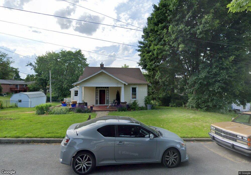
201 N Poplar St Dallastown, PA 17313
Estimated Value: $213,000 - $256,000
4
Beds
2
Baths
1,700
Sq Ft
$140/Sq Ft
Est. Value
About This Home
This home is located at 201 N Poplar St, Dallastown, PA 17313 and is currently estimated at $237,807, approximately $139 per square foot. 201 N Poplar St is a home located in York County with nearby schools including Dallastown Elementary School, Dallastown Area Middle School, and Dallastown Area High School.
Ownership History
Date
Name
Owned For
Owner Type
Purchase Details
Closed on
May 27, 2004
Sold by
Va
Bought by
Martin Teresa E
Current Estimated Value
Purchase Details
Closed on
Sep 16, 2003
Sold by
Cayer Arthur P and Cayer Mary D
Bought by
Va
Create a Home Valuation Report for This Property
The Home Valuation Report is an in-depth analysis detailing your home's value as well as a comparison with similar homes in the area
Home Values in the Area
Average Home Value in this Area
Purchase History
| Date | Buyer | Sale Price | Title Company |
|---|---|---|---|
| Martin Teresa E | $60,000 | -- | |
| Va | $51,201 | -- |
Source: Public Records
Tax History Compared to Growth
Tax History
| Year | Tax Paid | Tax Assessment Tax Assessment Total Assessment is a certain percentage of the fair market value that is determined by local assessors to be the total taxable value of land and additions on the property. | Land | Improvement |
|---|---|---|---|---|
| 2025 | $3,172 | $91,330 | $20,600 | $70,730 |
| 2024 | $3,172 | $91,330 | $20,600 | $70,730 |
| 2023 | $3,172 | $91,330 | $20,600 | $70,730 |
| 2022 | $3,071 | $91,330 | $20,600 | $70,730 |
| 2021 | $2,896 | $91,330 | $20,600 | $70,730 |
| 2020 | $2,896 | $91,330 | $20,600 | $70,730 |
| 2019 | $2,887 | $91,330 | $20,600 | $70,730 |
| 2018 | $2,887 | $91,330 | $20,600 | $70,730 |
| 2017 | $2,775 | $91,330 | $20,600 | $70,730 |
| 2016 | $0 | $91,330 | $20,600 | $70,730 |
| 2015 | -- | $91,330 | $20,600 | $70,730 |
| 2014 | -- | $91,330 | $20,600 | $70,730 |
Source: Public Records
Map
Nearby Homes
- 263 W Main St
- 53 S Franklin St
- 79 S Franklin St
- 18 E Howard St
- 2981 Sunset Dr
- 197 S Main St
- 74 S Main St
- 141 W Water St
- 430 E Maple St
- 0 Lot 15 Gary Dr
- 117 S Park St
- 1 N Duke St
- 114 Heather Glen Dr
- 55 Belmar Dr
- 227 Jutland Way
- 680 Hampstead Ct
- 350 Avon Dr Unit 270
- 374 Avon Dr Unit 282
- 2960 Starfire Dr
- 705 Summit Dr
- 308 W Chestnut St
- 351 W Broad St
- 335 W Broad St
- 355 W Broad St
- 256 N Poplar St
- 250 N Poplar St
- 357 W Broad St
- 282 W Chestnut St
- 273 W Chestnut St Unit 1
- 271 W Chestnut St Unit 2
- 273 W Broad St
- 269 W Chestnut St Unit 3
- 359 W Broad St
- 338 W Broad St
- 337 W Chestnut St Unit 20
- 267 W Chestnut St Unit 4
- 333 W Chestnut St Unit 21
- 341 W Chestnut St Unit 19
- 372 W Chestnut St
- 346 W Broad St