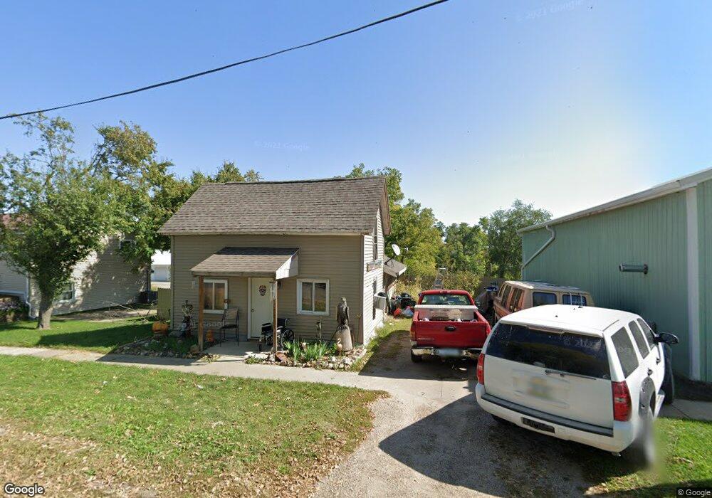
201 Pearl St NE Shellsburg, IA 52332
Estimated Value: $118,000 - $259,000
3
Beds
2
Baths
1,654
Sq Ft
$114/Sq Ft
Est. Value
About This Home
This home is located at 201 Pearl St NE, Shellsburg, IA 52332 and is currently estimated at $187,778, approximately $113 per square foot. 201 Pearl St NE is a home located in Benton County with nearby schools including Shellsburg Elementary School, Tilford Elementary School, and Vinton-Shellsburg Middle School.
Ownership History
Date
Name
Owned For
Owner Type
Purchase Details
Closed on
Jul 17, 2009
Sold by
Houtzager Levina and Bruce Louise
Bought by
Schminke Shawn A
Current Estimated Value
Home Financials for this Owner
Home Financials are based on the most recent Mortgage that was taken out on this home.
Original Mortgage
$52,000
Outstanding Balance
$33,956
Interest Rate
5.32%
Mortgage Type
New Conventional
Estimated Equity
$153,822
Create a Home Valuation Report for This Property
The Home Valuation Report is an in-depth analysis detailing your home's value as well as a comparison with similar homes in the area
Home Values in the Area
Average Home Value in this Area
Purchase History
| Date | Buyer | Sale Price | Title Company |
|---|---|---|---|
| Schminke Shawn A | $65,000 | None Available |
Source: Public Records
Mortgage History
| Date | Status | Borrower | Loan Amount |
|---|---|---|---|
| Open | Schminke Shawn A | $52,000 |
Source: Public Records
Tax History Compared to Growth
Tax History
| Year | Tax Paid | Tax Assessment Tax Assessment Total Assessment is a certain percentage of the fair market value that is determined by local assessors to be the total taxable value of land and additions on the property. | Land | Improvement |
|---|---|---|---|---|
| 2025 | $2,100 | $138,500 | $28,000 | $110,500 |
| 2024 | $2,100 | $130,000 | $28,000 | $102,000 |
| 2023 | $1,954 | $130,000 | $28,000 | $102,000 |
| 2022 | $1,930 | $107,200 | $22,400 | $84,800 |
| 2021 | $1,930 | $107,200 | $22,400 | $84,800 |
| 2020 | $1,158 | $67,100 | $22,500 | $44,600 |
| 2019 | $1,292 | $67,100 | $22,500 | $44,600 |
| 2018 | $1,242 | $73,700 | $19,000 | $54,700 |
| 2017 | $1,252 | $73,700 | $19,000 | $54,700 |
| 2016 | $1,224 | $70,900 | $18,300 | $52,600 |
| 2015 | $1,224 | $70,900 | $18,300 | $52,600 |
| 2014 | $1,306 | $76,600 | $0 | $0 |
Source: Public Records
Map
Nearby Homes
- 201 Grove St NW
- 205 Grove St NW
- 404 Main St NW
- 6127 32nd Ave Unit Lot 3
- 700 Sunset Blvd
- 101 Meadow Dr
- 804 Fairway Dr
- 103 Meadow Dr
- 105 Meadow Dr
- 301 Wildcat Ct
- 6240 33rd Avenue Dr
- 0 31st Ave
- 810 Indigo Dr
- 737 Indigo Dr
- 818 Indigo Dr
- 819 Indigo Dr
- 827 Indigo Dr
- 803 Indigo Dr
- 2773 Ridgeview Dr
- 2573 Linn Benton Rd
- 201 Pearl St NE
- 203 Pearl St NE
- 204 Pearl St
- 101 Grove St NW
- 103 Pearl St NE
- 210 Pearl St NE
- 207 Pearl St NE
- 107 Grove St NW
- 120 Cottage St NW
- 101 Main St E
- 105 Main St NE
- 104 Grove St NW
- 102 Cottage St NW
- 107 Main St NE
- 101 Cottage St NW
- 111 Grove St NW
- 205 Main St NE
- 111 Main St NW
- 109 Main St NW
- 115 Main St NW