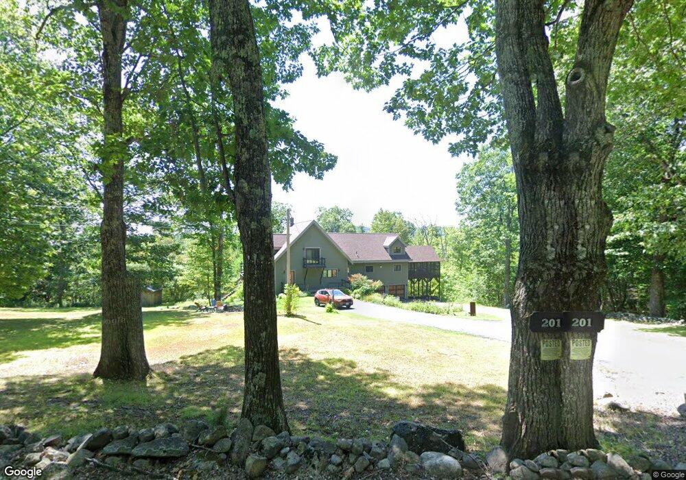
201 Red Hill Rd Moultonborough, NH 03254
Estimated Value: $856,000 - $1,192,000
1
Bed
1
Bath
945
Sq Ft
$1,063/Sq Ft
Est. Value
About This Home
This home is located at 201 Red Hill Rd, Moultonborough, NH 03254 and is currently estimated at $1,004,786, approximately $1,063 per square foot. 201 Red Hill Rd is a home located in Carroll County with nearby schools including Moultonborough Central School and Moultonborough Academy High School.
Ownership History
Date
Name
Owned For
Owner Type
Purchase Details
Closed on
Oct 22, 2020
Sold by
Porter Kristen E
Bought by
Porter Kristen E and Boyer Andrea
Current Estimated Value
Purchase Details
Closed on
Sep 14, 2012
Sold by
Annese Mark P and Fnma
Bought by
Federal National Mortgage Association
Create a Home Valuation Report for This Property
The Home Valuation Report is an in-depth analysis detailing your home's value as well as a comparison with similar homes in the area
Home Values in the Area
Average Home Value in this Area
Purchase History
| Date | Buyer | Sale Price | Title Company |
|---|---|---|---|
| Porter Kristen E | -- | None Available | |
| Porter Kristen E | -- | None Available | |
| Federal National Mortgage Association | $266,400 | -- | |
| Federal National Mortgage Association | $266,400 | -- |
Source: Public Records
Mortgage History
| Date | Status | Borrower | Loan Amount |
|---|---|---|---|
| Closed | Federal National Mortgage Association | $0 |
Source: Public Records
Tax History Compared to Growth
Tax History
| Year | Tax Paid | Tax Assessment Tax Assessment Total Assessment is a certain percentage of the fair market value that is determined by local assessors to be the total taxable value of land and additions on the property. | Land | Improvement |
|---|---|---|---|---|
| 2024 | $4,370 | $773,400 | $115,900 | $657,500 |
| 2023 | $3,957 | $694,200 | $87,900 | $606,300 |
| 2022 | $3,013 | $630,400 | $79,200 | $551,200 |
| 2021 | $3,794 | $543,500 | $65,000 | $478,500 |
| 2020 | $3,907 | $547,900 | $89,500 | $458,400 |
| 2019 | $3,218 | $450,100 | $89,500 | $360,600 |
| 2018 | $3,513 | $455,100 | $83,200 | $371,900 |
| 2017 | $3,263 | $397,000 | $83,200 | $313,800 |
| 2016 | $3,432 | $392,700 | $83,200 | $309,500 |
| 2015 | $3,335 | $370,100 | $89,100 | $281,000 |
| 2014 | $3,058 | $345,200 | $89,100 | $256,100 |
| 2013 | $3,026 | $348,200 | $89,100 | $259,100 |
Source: Public Records
Map
Nearby Homes
- 21 Burton Rd
- 100 Marvin Rd
- 11 Jennifer's Path
- 525 Whittier Hwy
- 25 Whittier Hwy
- 38 Lake Shore Dr Unit 12
- 38 Lake Shore Dr Unit 10
- 00 Whittier Hwy Unit 8
- 4 Schneider Rd
- 647 Whittier Hwy
- 52 Chase Cir
- 33 Blackadar Ln
- 20 Coe Hill Rd
- 24 Dew Point Ln
- 145 Hanson Dr
- 69 Buoniello Rd
- 122 Coe Hill Rd
- 320 Redding Ln
- M:027 L:002-001 Sheridan Rd
- M:027 L:002 Sheridan Rd
- 201 Red Hill Rd
- 187 Red Hill Rd
- 200 Red Hill Rd
- 234 Red Hill Rd
- 184 Red Hill Rd
- 87 Bishop Shore Rd
- 75 Bishop Shore Rd
- 73 Bishop Shore Rd
- 168 Red Hill Rd
- 53 Bishop Shore Rd
- 61 Bishop Shore Rd
- 67 Bishop Shore Rd
- 43 Bishop Shore Rd
- 150 Red Hill Rd
- 35 Bishop Shore Rd
- 33 Bishop Shore Rd
- 29 Bishop Shore Rd
- 240 Red Hill Rd
- 15 Bishop Shore Rd
- 21 Bishop Shore Rd