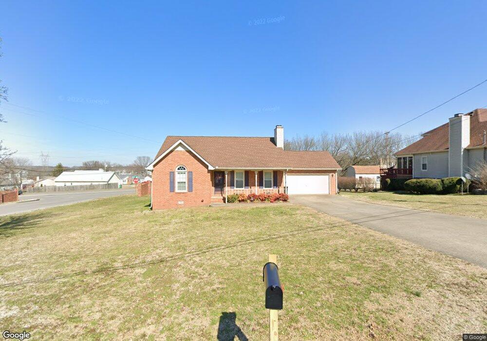
201 Saint Pauls Ln Smyrna, TN 37167
Estimated Value: $330,562 - $391,000
--
Bed
2
Baths
1,278
Sq Ft
$285/Sq Ft
Est. Value
About This Home
This home is located at 201 Saint Pauls Ln, Smyrna, TN 37167 and is currently estimated at $364,141, approximately $284 per square foot. 201 Saint Pauls Ln is a home located in Rutherford County with nearby schools including Rocky Fork Elementary School, Rocky Fork Middle School, and Smyrna High School.
Ownership History
Date
Name
Owned For
Owner Type
Purchase Details
Closed on
Jun 25, 2021
Sold by
Jones Deborah S and Williams Deborah S
Bought by
Williams Richard M and Williams Deborah S
Current Estimated Value
Purchase Details
Closed on
Jan 24, 2006
Sold by
Harold Hunter
Bought by
Jones Deborah S
Purchase Details
Closed on
Nov 2, 1995
Sold by
Charles Reed
Bought by
Jones Deborah S and Jones Hunter H
Create a Home Valuation Report for This Property
The Home Valuation Report is an in-depth analysis detailing your home's value as well as a comparison with similar homes in the area
Home Values in the Area
Average Home Value in this Area
Purchase History
| Date | Buyer | Sale Price | Title Company |
|---|---|---|---|
| Williams Richard M | -- | Accommodation | |
| Jones Deborah S | -- | -- | |
| Jones Deborah S | $104,900 | -- |
Source: Public Records
Tax History Compared to Growth
Tax History
| Year | Tax Paid | Tax Assessment Tax Assessment Total Assessment is a certain percentage of the fair market value that is determined by local assessors to be the total taxable value of land and additions on the property. | Land | Improvement |
|---|---|---|---|---|
| 2025 | $1,733 | $72,150 | $13,750 | $58,400 |
| 2024 | $1,733 | $72,150 | $13,750 | $58,400 |
| 2023 | $1,733 | $72,150 | $13,750 | $58,400 |
| 2022 | $1,545 | $72,150 | $13,750 | $58,400 |
| 2021 | $1,442 | $49,400 | $10,500 | $38,900 |
| 2020 | $1,442 | $49,400 | $10,500 | $38,900 |
| 2019 | $1,442 | $49,400 | $10,500 | $38,900 |
| 2018 | $1,383 | $49,400 | $0 | $0 |
| 2017 | $1,298 | $36,425 | $0 | $0 |
| 2016 | $1,298 | $36,425 | $0 | $0 |
| 2015 | $1,298 | $36,425 | $0 | $0 |
| 2014 | $906 | $36,425 | $0 | $0 |
| 2013 | -- | $37,650 | $0 | $0 |
Source: Public Records
Map
Nearby Homes
- 115 Saint Michaels Ln
- 421 Saint Francis Ave
- 1102 Forestwood Ct
- 107 Irish Place
- 407 Shadowood Dr
- 508 Williamsport Dr
- 508 Spinnaker Ct
- 502 Saint Francis Ave
- 505 Spinnaker Ct
- 304 Short Ct
- 143 Stokes Dr
- 806 Enon Springs Rd W
- 400 Megan Dr
- 715 Saint Francis Ave
- 650 Spring Hill Dr
- 502 Johnstown Dr
- 726 Mason Tucker Dr
- 499 Williamsport Dr
- 630 Rock Springs Rd
- 520 Mcgrath Dr
- 733 Lipizanner Ln
- 705 Lipizanner Ln
- 737 Lipizanner Ln
- 717 Lipizanner Ln
- 729 Lipizanner Ln
- 741 Lipizanner Ln
- 745 Lipizanner Ln
- 203 Saint Pauls Ln
- 100 Saint Michaels Ln
- 103 Saint Michaels Ln
- 202 Saint Pauls Ln
- 815 Clearspring Ct
- 102 Saint Michaels Ln
- 207 Saint Pauls Ln
- 817 Clearspring Ct
- 105 Saint Michaels Ln
- 102 Kelly Dr
- 813 Clearspring Ct
- 209 Saint Pauls Ln
- 810 Clearspring Ct