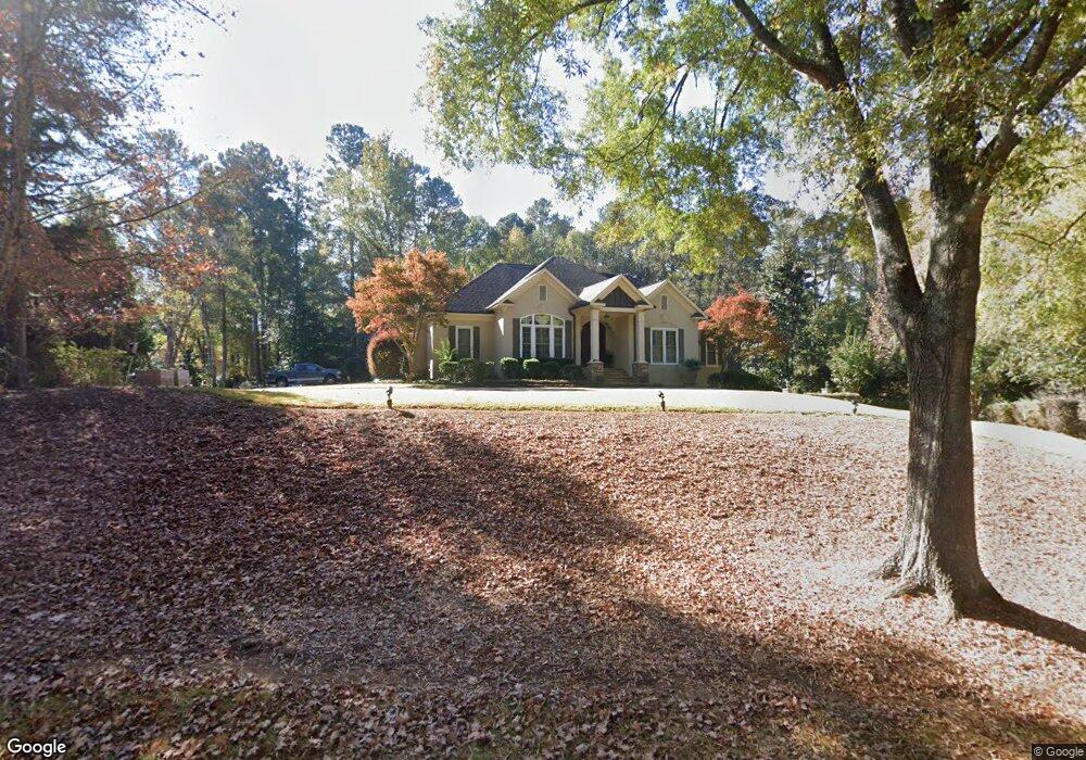
201 Victoria Dr Lagrange, GA 30240
Estimated Value: $659,000 - $830,000
4
Beds
8
Baths
2,581
Sq Ft
$283/Sq Ft
Est. Value
About This Home
This home is located at 201 Victoria Dr, Lagrange, GA 30240 and is currently estimated at $729,269, approximately $282 per square foot. 201 Victoria Dr is a home located in Troup County with nearby schools including Hollis Hand Elementary School, Ethel W. Kight Elementary School, and Franklin Forest Elementary School.
Ownership History
Date
Name
Owned For
Owner Type
Purchase Details
Closed on
Feb 22, 2005
Sold by
Kurz Roger C
Bought by
Cannady Ronald
Current Estimated Value
Home Financials for this Owner
Home Financials are based on the most recent Mortgage that was taken out on this home.
Original Mortgage
$266,000
Interest Rate
5.6%
Mortgage Type
New Conventional
Purchase Details
Closed on
Jul 3, 2001
Sold by
Mark C Callaway
Bought by
Kurz Roger C and Kurz Elizabeth S
Purchase Details
Closed on
Aug 19, 1992
Sold by
Averett
Bought by
Mark C Callaway
Purchase Details
Closed on
Feb 17, 1992
Sold by
Jerry Averett
Bought by
Averett
Purchase Details
Closed on
Nov 2, 1990
Sold by
Nancy Edward and Nancy Long
Bought by
Jerry Averett
Purchase Details
Closed on
Aug 9, 1988
Sold by
Spinks-Brown Realty
Bought by
Nancy Edward and Nancy Long
Purchase Details
Closed on
Dec 1, 1987
Bought by
Spinks-Brown Realty
Create a Home Valuation Report for This Property
The Home Valuation Report is an in-depth analysis detailing your home's value as well as a comparison with similar homes in the area
Home Values in the Area
Average Home Value in this Area
Purchase History
| Date | Buyer | Sale Price | Title Company |
|---|---|---|---|
| Cannady Ronald | $380,000 | -- | |
| Kurz Roger C | $364,900 | -- | |
| Mark C Callaway | $284,200 | -- | |
| Averett | $36,500 | -- | |
| Jerry Averett | $36,500 | -- | |
| Nancy Edward | $36,000 | -- | |
| Spinks-Brown Realty | -- | -- |
Source: Public Records
Mortgage History
| Date | Status | Borrower | Loan Amount |
|---|---|---|---|
| Closed | Cannady Ronald | $266,000 |
Source: Public Records
Tax History Compared to Growth
Tax History
| Year | Tax Paid | Tax Assessment Tax Assessment Total Assessment is a certain percentage of the fair market value that is determined by local assessors to be the total taxable value of land and additions on the property. | Land | Improvement |
|---|---|---|---|---|
| 2024 | $6,881 | $254,280 | $18,000 | $236,280 |
| 2023 | $6,688 | $247,200 | $18,000 | $229,200 |
| 2022 | $6,693 | $241,800 | $18,000 | $223,800 |
| 2021 | $6,613 | $221,240 | $18,000 | $203,240 |
| 2020 | $6,613 | $221,240 | $18,000 | $203,240 |
| 2019 | $6,541 | $218,880 | $18,000 | $200,880 |
| 2018 | $6,539 | $218,800 | $18,000 | $200,800 |
| 2017 | $6,539 | $218,800 | $18,000 | $200,800 |
| 2016 | $6,699 | $224,103 | $18,000 | $206,103 |
| 2015 | $6,710 | $224,103 | $18,000 | $206,103 |
| 2014 | $6,410 | $213,797 | $18,000 | $195,797 |
| 2013 | -- | $212,289 | $19,602 | $192,687 |
Source: Public Records
Map
Nearby Homes
- 114 Morgan Dr
- 654 Cameron Mill Rd
- 116 Morgan Dr
- 114-116 Morgan Dr
- 114 Millridge Dr
- 101 Deal Dr
- 116 Deal Dr
- 102 Willowcrest Way
- 106 Highland Park
- 0 Cameron Mill Rd Unit 10640133
- 641 Whitaker Rd
- 208 Highland Trail
- 108 Spring Valley Dr
- 104 Spring Valley Dr
- 223 Pinehaven Dr
- 117 Brookwood Dr
- 200 Cheyenne Dr
- 603 Country Club Rd
- 107 Cameron Pointe Dr
- 103 Cameron Pointe Dr
- 107 Victoria Dr
- 108 Victoria Dr
- 200 Victoria Dr
- 106 Victoria Dr
- 202 Victoria Dr
- 105 Victoria Dr
- 104 Victoria Dr
- 104 Morgan Dr
- 108 Morgan Dr
- 112 Morgan Dr
- 102 Victoria Dr
- 103 Victoria Dr
- 302 Victoria Pointe
- 302 Victoria Pointe
- 106 Morgan Dr
- 102 Morgan Dr
- 112 Victoria Dr
- 304 Victoria Pointe
- 622 Cameron Mill Rd
- 303 Victoria Pointe