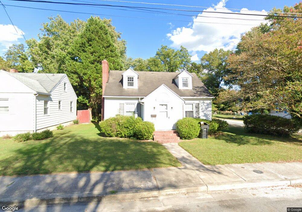
201 Walston Ave Salisbury, MD 21804
Church Street-Doverdale NeighborhoodEstimated Value: $151,398 - $200,000
--
Bed
1
Bath
984
Sq Ft
$185/Sq Ft
Est. Value
About This Home
This home is located at 201 Walston Ave, Salisbury, MD 21804 and is currently estimated at $181,600, approximately $184 per square foot. 201 Walston Ave is a home located in Wicomico County with nearby schools including Beaver Run Elementary School, East Salisbury Elementary School, and Wicomico Middle School.
Ownership History
Date
Name
Owned For
Owner Type
Purchase Details
Closed on
May 27, 1997
Sold by
Hoge Frank E and Hoge Catherine M
Bought by
Hoge Catherine M
Current Estimated Value
Purchase Details
Closed on
Mar 28, 1997
Sold by
Hoge Frank E and Hoge Catherine M
Bought by
Hoge Catherine M
Purchase Details
Closed on
Aug 27, 1986
Sold by
Rogers Gerald T
Bought by
Hoge Frank E and Hoge Catherine M
Home Financials for this Owner
Home Financials are based on the most recent Mortgage that was taken out on this home.
Original Mortgage
$38,400
Interest Rate
10.04%
Create a Home Valuation Report for This Property
The Home Valuation Report is an in-depth analysis detailing your home's value as well as a comparison with similar homes in the area
Home Values in the Area
Average Home Value in this Area
Purchase History
| Date | Buyer | Sale Price | Title Company |
|---|---|---|---|
| Hoge Catherine M | -- | -- | |
| Hoge Catherine M | -- | -- | |
| Hoge Frank E | $42,000 | -- |
Source: Public Records
Mortgage History
| Date | Status | Borrower | Loan Amount |
|---|---|---|---|
| Previous Owner | Hoge Frank E | $38,400 |
Source: Public Records
Tax History Compared to Growth
Tax History
| Year | Tax Paid | Tax Assessment Tax Assessment Total Assessment is a certain percentage of the fair market value that is determined by local assessors to be the total taxable value of land and additions on the property. | Land | Improvement |
|---|---|---|---|---|
| 2025 | $941 | $106,767 | $0 | $0 |
| 2024 | $941 | $98,100 | $18,600 | $79,500 |
| 2023 | $846 | $85,533 | $0 | $0 |
| 2022 | $744 | $72,967 | $0 | $0 |
| 2021 | $617 | $60,400 | $18,600 | $41,800 |
| 2020 | $608 | $58,967 | $0 | $0 |
| 2019 | $602 | $57,533 | $0 | $0 |
| 2018 | $1,162 | $56,100 | $18,600 | $37,500 |
| 2017 | $1,162 | $56,100 | $0 | $0 |
| 2016 | -- | $56,100 | $0 | $0 |
| 2015 | $1,313 | $56,400 | $0 | $0 |
| 2014 | $1,313 | $56,400 | $0 | $0 |
Source: Public Records
Map
Nearby Homes
- 124 Priscilla St
- 204 Holland Ave
- 131 Truitt St
- 211 Truitt St
- 1012 Phillips Ave
- 201 Marshall St
- 309 Marshall St
- 411 Dover St
- 430 Priscilla St
- 322 Naylor St
- 923 Preston St
- 1209 Belmont Ave
- 909 Johnson St
- 608 Spring Garden Ave
- 615 Hammond St
- 625 Liberty St
- 722 S Park Dr
- 0 Civic Avenue & Beaglin Park Dr
- 113 Montleau Ave
- 309 Park Heights Ave
- 203 Walston Ave
- 123 Walston Ave
- 205 Walston Ave
- 122 Priscilla St
- 207 Walston Ave
- 120 Priscilla St
- 204 Walston Ave
- 122 Walston Ave
- 118 Priscilla St
- 121 Walston Ave
- 206 Walston Ave
- 202 Walston Ave
- 120 Walston Ave
- 209 Walston Ave
- 200 Priscilla St
- 119 Walston Ave
- 116 Priscilla St
- 118 Walston Ave
- 202 Priscilla St
- 208 Walston Ave