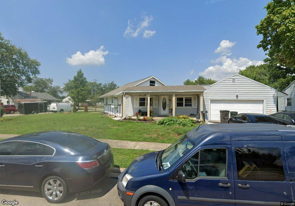
201 William St Dayton, OH 45449
Estimated Value: $115,000 - $159,000
3
Beds
1
Bath
1,356
Sq Ft
$100/Sq Ft
Est. Value
About This Home
This home is located at 201 William St, Dayton, OH 45449 and is currently estimated at $135,101, approximately $99 per square foot. 201 William St is a home located in Montgomery County with nearby schools including West Carrollton High School, Miami Valley Academies, and Bishop Leibold School.
Ownership History
Date
Name
Owned For
Owner Type
Purchase Details
Closed on
Sep 16, 2021
Sold by
Dayton Lyon Construction Llc
Bought by
Leon Angel Teodoro Orellana
Current Estimated Value
Purchase Details
Closed on
Mar 7, 2018
Sold by
Secretary Of Veterans Affairs
Bought by
Dayton Lyon Construction Llc
Purchase Details
Closed on
Dec 28, 2017
Sold by
Pnc Bank
Bought by
Secretary Of Veterans Affairs
Purchase Details
Closed on
Dec 18, 2017
Sold by
Bundy Mark L and Bundy Mark
Bought by
Pnc Bank Na
Purchase Details
Closed on
Jun 3, 2005
Sold by
Kibler Melissa L
Bought by
Bundy Mark L
Home Financials for this Owner
Home Financials are based on the most recent Mortgage that was taken out on this home.
Original Mortgage
$90,811
Interest Rate
5.86%
Mortgage Type
VA
Create a Home Valuation Report for This Property
The Home Valuation Report is an in-depth analysis detailing your home's value as well as a comparison with similar homes in the area
Home Values in the Area
Average Home Value in this Area
Purchase History
| Date | Buyer | Sale Price | Title Company |
|---|---|---|---|
| Leon Angel Teodoro Orellana | $78,300 | None Available | |
| Dayton Lyon Construction Llc | -- | Vantage Land Title | |
| Secretary Of Veterans Affairs | -- | None Available | |
| Pnc Bank Na | $60,000 | None Available | |
| Bundy Mark L | $88,900 | -- |
Source: Public Records
Mortgage History
| Date | Status | Borrower | Loan Amount |
|---|---|---|---|
| Previous Owner | Bundy Mark L | $90,811 |
Source: Public Records
Tax History
| Year | Tax Paid | Tax Assessment Tax Assessment Total Assessment is a certain percentage of the fair market value that is determined by local assessors to be the total taxable value of land and additions on the property. | Land | Improvement |
|---|---|---|---|---|
| 2025 | $2,536 | $36,690 | $6,760 | $29,930 |
| 2024 | $2,358 | $36,690 | $6,760 | $29,930 |
| 2023 | $2,358 | $36,690 | $6,760 | $29,930 |
| 2022 | $2,244 | $27,370 | $5,040 | $22,330 |
| 2021 | $2,248 | $27,370 | $5,040 | $22,330 |
| 2020 | $2,293 | $27,370 | $5,040 | $22,330 |
| 2019 | $2,558 | $28,440 | $5,250 | $23,190 |
| 2018 | $5,284 | $28,440 | $5,250 | $23,190 |
| 2017 | $3,075 | $28,440 | $5,250 | $23,190 |
| 2016 | $2,465 | $29,410 | $5,250 | $24,160 |
| 2015 | $2,272 | $29,410 | $5,250 | $24,160 |
| 2014 | $2,272 | $29,410 | $5,250 | $24,160 |
| 2012 | -- | $24,930 | $7,000 | $17,930 |
Source: Public Records
Map
Nearby Homes
- 217 E Home Ave
- 209 E Cottage Ave
- 428 E Cottage Ave
- 316 E Pease Ave
- 12 E Main St
- 21 W Main St
- 9 W Lowery Ave
- 201 S Smith St
- 322 Savoy Ave
- 518 Regal Ave
- 11 Airstream Dr
- 509 Windsor Ave
- 109 Tulip Dr
- 3553 Trail On Rd
- 96 Airstream Dr
- 26 Southard Ln
- 232 Tulip Dr
- 3488 Parallel Rd
- 758 Cransberry Dr
- 1000 Skyview Dr
Your Personal Tour Guide
Ask me questions while you tour the home.