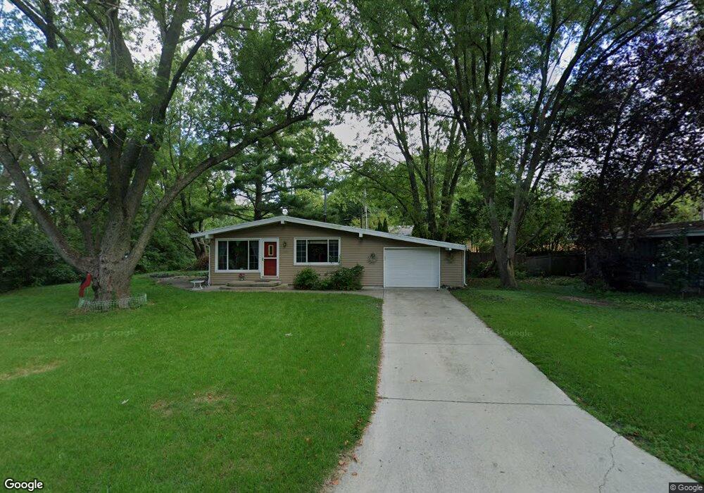
2010 Cypress Dr Champaign, IL 61821
West Haven NeighborhoodEstimated Value: $171,000 - $207,000
--
Bed
1
Bath
1,092
Sq Ft
$174/Sq Ft
Est. Value
About This Home
This home is located at 2010 Cypress Dr, Champaign, IL 61821 and is currently estimated at $190,449, approximately $174 per square foot. 2010 Cypress Dr is a home located in Champaign County with nearby schools including Centennial High School, St. John Lutheran School, and Montessori Habitat School.
Ownership History
Date
Name
Owned For
Owner Type
Purchase Details
Closed on
Apr 9, 2008
Sold by
Seyfert Stephan P and Seyfert Lesli A
Bought by
Pointer Nilda J
Current Estimated Value
Home Financials for this Owner
Home Financials are based on the most recent Mortgage that was taken out on this home.
Original Mortgage
$111,497
Interest Rate
6.32%
Mortgage Type
Purchase Money Mortgage
Create a Home Valuation Report for This Property
The Home Valuation Report is an in-depth analysis detailing your home's value as well as a comparison with similar homes in the area
Home Values in the Area
Average Home Value in this Area
Purchase History
| Date | Buyer | Sale Price | Title Company |
|---|---|---|---|
| Pointer Nilda J | $124,000 | None Available |
Source: Public Records
Mortgage History
| Date | Status | Borrower | Loan Amount |
|---|---|---|---|
| Closed | Pointer Nilda J | $111,497 |
Source: Public Records
Tax History Compared to Growth
Tax History
| Year | Tax Paid | Tax Assessment Tax Assessment Total Assessment is a certain percentage of the fair market value that is determined by local assessors to be the total taxable value of land and additions on the property. | Land | Improvement |
|---|---|---|---|---|
| 2024 | $3,272 | $46,420 | $12,360 | $34,060 |
| 2023 | $3,272 | $42,280 | $11,260 | $31,020 |
| 2022 | $3,036 | $39,010 | $10,390 | $28,620 |
| 2021 | $2,952 | $38,250 | $10,190 | $28,060 |
| 2020 | $2,888 | $37,500 | $9,990 | $27,510 |
| 2019 | $2,783 | $36,720 | $9,780 | $26,940 |
| 2018 | $2,713 | $36,150 | $9,630 | $26,520 |
| 2017 | $2,724 | $36,150 | $9,630 | $26,520 |
| 2016 | $2,432 | $35,400 | $9,430 | $25,970 |
| 2015 | $2,441 | $34,770 | $9,260 | $25,510 |
| 2014 | $2,420 | $34,770 | $9,260 | $25,510 |
| 2013 | $2,398 | $34,770 | $9,260 | $25,510 |
Source: Public Records
Map
Nearby Homes
- 1801 Crescent Dr
- 1908 Barberry Cir
- 2001 S Mattis Ave Unit E
- 2003 W Kirby Ave
- 2313 Glenoak Dr
- 2203 W Kirby Ave
- 2302 Blackthorn Dr
- 1601 Carolyn Dr
- 1901 Lakeside Dr Unit B
- 1928 Blackthorn Dr Unit 1
- 2113 Sunview Dr
- 1612 W Kirby Ave
- 1410 S Mattis Ave
- 1420 S Western Ave
- 2144 Harbortown Cir Unit 2144
- 2306 Winchester Dr
- 1407 Kenwood Rd
- 1901 Branch Rd
- 2605 Trafalgar Square
- 1318 Broadmoor Dr
- 2008 Cypress Dr
- 2007 Broadmoor Dr
- 2009 Broadmoor Dr
- 2006 Cypress Dr
- 2006 Cypress Dr Unit 1
- 2005 Broadmoor Dr
- 2004 Cypress Dr
- 1822 Crescent Dr
- 2003 Broadmoor Dr
- 2105 Cypress Dr
- 2010 Broadmoor Dr
- 2003 Cypress Dr
- 1824 Crescent Dr
- 2008 Broadmoor Dr
- 1813 Clover Ln
- 2106 Cypress Dr
- 2006 Broadmoor Dr
- 1826 Crescent Dr
- 1811 Clover Ln
- 2001 Cypress Dr