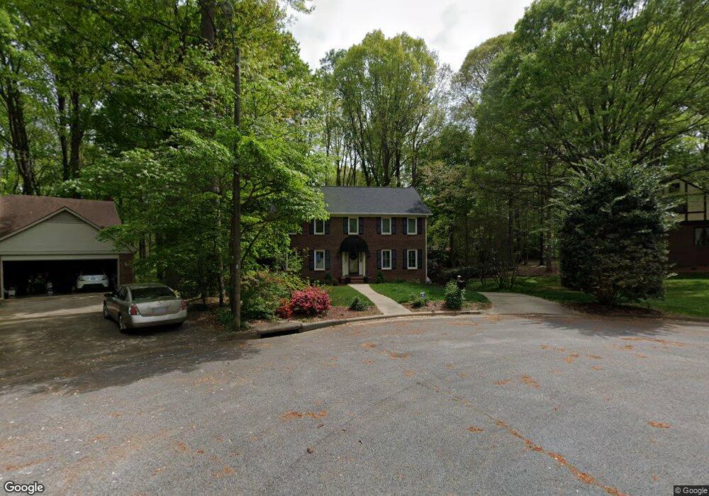
2010 La Dora Ct High Point, NC 27265
Deep River NeighborhoodEstimated Value: $521,000 - $573,000
4
Beds
3
Baths
2,950
Sq Ft
$183/Sq Ft
Est. Value
About This Home
This home is located at 2010 La Dora Ct, High Point, NC 27265 and is currently estimated at $540,980, approximately $183 per square foot. 2010 La Dora Ct is a home located in Guilford County with nearby schools including Southwest Elementary School, Welborn Academy of Science & Technology, and T.W. Andrews High School.
Ownership History
Date
Name
Owned For
Owner Type
Purchase Details
Closed on
Sep 13, 2000
Sold by
Fulcher Leonard J
Bought by
Pettie James Drew and Pettie Deanea Marie
Current Estimated Value
Home Financials for this Owner
Home Financials are based on the most recent Mortgage that was taken out on this home.
Original Mortgage
$250,000
Outstanding Balance
$91,568
Interest Rate
8.17%
Estimated Equity
$449,412
Purchase Details
Closed on
Aug 31, 1998
Sold by
Alton Cadenhead Roy and Suzanne Mary
Bought by
Fulcher Leonard J and Fulcher Brenda
Home Financials for this Owner
Home Financials are based on the most recent Mortgage that was taken out on this home.
Original Mortgage
$197,000
Interest Rate
6.96%
Create a Home Valuation Report for This Property
The Home Valuation Report is an in-depth analysis detailing your home's value as well as a comparison with similar homes in the area
Home Values in the Area
Average Home Value in this Area
Purchase History
| Date | Buyer | Sale Price | Title Company |
|---|---|---|---|
| Pettie James Drew | $282,000 | -- | |
| Fulcher Leonard J | $247,000 | -- |
Source: Public Records
Mortgage History
| Date | Status | Borrower | Loan Amount |
|---|---|---|---|
| Open | Pettie James Drew | $250,000 | |
| Previous Owner | Fulcher Leonard J | $197,000 |
Source: Public Records
Tax History Compared to Growth
Tax History
| Year | Tax Paid | Tax Assessment Tax Assessment Total Assessment is a certain percentage of the fair market value that is determined by local assessors to be the total taxable value of land and additions on the property. | Land | Improvement |
|---|---|---|---|---|
| 2025 | $4,609 | $334,500 | $54,000 | $280,500 |
| 2024 | $4,609 | $334,500 | $54,000 | $280,500 |
| 2023 | $4,609 | $334,500 | $54,000 | $280,500 |
| 2022 | $4,509 | $334,500 | $54,000 | $280,500 |
| 2021 | $4,246 | $308,100 | $45,000 | $263,100 |
| 2020 | $4,246 | $308,100 | $45,000 | $263,100 |
| 2019 | $4,246 | $308,100 | $0 | $0 |
| 2018 | $4,224 | $308,100 | $0 | $0 |
| 2017 | $4,246 | $308,100 | $0 | $0 |
| 2016 | $4,064 | $289,800 | $0 | $0 |
| 2015 | $4,086 | $289,800 | $0 | $0 |
| 2014 | $4,156 | $289,800 | $0 | $0 |
Source: Public Records
Map
Nearby Homes
- 2200 Delaine Point
- 4307 Oak Hollow Dr
- 2115 Mirus Ct
- 4218 Pelican St
- 4407 Oak Hollow Dr
- 3753 Carvette Ct
- 4404 Essex Ct
- 1935 Eastchester Dr
- 4004 Baywater Point
- 3905 Wynne Brook Ct
- 3710 Spanish Peak Dr Unit 2D
- 3521 Sunset Hollow Ct
- 3724 Spanish Peak Dr Unit 2B
- 3924 Braddock Rd
- 4126 Birchgarden Dr
- 2512 Burch Point
- 1924 Middlewood Ct
- 2754 Mossy Meadow Dr
- 4103 Quarterstaff Ct
- 1515 Skeet Club Rd
- 2008 La Dora Ct
- 2012 La Dora Ct
- 2013 La Vista Dr
- 2011 La Vista Dr
- 2014 La Dora Ct
- 2009 La Vista Dr
- 2004 La Dora Dr
- 2016 La Dora Dr
- 2015 La Vista Dr
- 2007 La Vista Dr
- 2018 La Dora Dr
- 2005 La Vista Dr
- 2002 La Dora Dr
- 2020 La Vista Dr
- 2003 La Vista Dr
- 2009 La Dora Dr
- 2011 La Dora Dr
- 2014 La Vista Dr
- 2012 La Vista Dr
- 2000 La Dora Dr