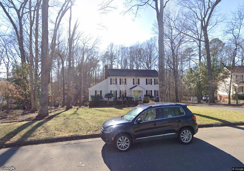
2011 Carbon Hill Dr Midlothian, VA 23113
Roxshire NeighborhoodEstimated Value: $619,131 - $681,000
4
Beds
4
Baths
3,035
Sq Ft
$214/Sq Ft
Est. Value
About This Home
This home is located at 2011 Carbon Hill Dr, Midlothian, VA 23113 and is currently estimated at $648,033, approximately $213 per square foot. 2011 Carbon Hill Dr is a home located in Chesterfield County with nearby schools including Robious Elementary School, Robious Middle School, and James River High School.
Ownership History
Date
Name
Owned For
Owner Type
Purchase Details
Closed on
Jan 5, 2001
Sold by
Wise Sarah H T
Bought by
Mcneil Matthew K and Mcneil Paola D
Current Estimated Value
Home Financials for this Owner
Home Financials are based on the most recent Mortgage that was taken out on this home.
Original Mortgage
$117,200
Outstanding Balance
$43,713
Interest Rate
7.69%
Mortgage Type
New Conventional
Estimated Equity
$604,320
Create a Home Valuation Report for This Property
The Home Valuation Report is an in-depth analysis detailing your home's value as well as a comparison with similar homes in the area
Home Values in the Area
Average Home Value in this Area
Purchase History
| Date | Buyer | Sale Price | Title Company |
|---|---|---|---|
| Mcneil Matthew K | $209,000 | -- |
Source: Public Records
Mortgage History
| Date | Status | Borrower | Loan Amount |
|---|---|---|---|
| Open | Mcneil Matthew K | $117,200 |
Source: Public Records
Tax History
| Year | Tax Paid | Tax Assessment Tax Assessment Total Assessment is a certain percentage of the fair market value that is determined by local assessors to be the total taxable value of land and additions on the property. | Land | Improvement |
|---|---|---|---|---|
| 2025 | $4,614 | $515,600 | $145,000 | $370,600 |
| 2024 | $4,614 | $491,900 | $135,000 | $356,900 |
| 2023 | $3,893 | $427,800 | $125,000 | $302,800 |
| 2022 | $3,747 | $407,300 | $115,000 | $292,300 |
| 2021 | $3,555 | $367,300 | $104,000 | $263,300 |
| 2020 | $3,367 | $354,400 | $104,000 | $250,400 |
| 2019 | $3,338 | $351,400 | $101,000 | $250,400 |
| 2018 | $3,220 | $338,900 | $99,000 | $239,900 |
| 2017 | $3,234 | $336,900 | $97,000 | $239,900 |
| 2016 | $3,224 | $335,800 | $97,000 | $238,800 |
| 2015 | $3,172 | $327,800 | $89,000 | $238,800 |
| 2014 | $3,068 | $317,000 | $82,000 | $235,000 |
Source: Public Records
Map
Nearby Homes
- 12111 Framar Dr
- 2101 Normandstone Dr
- 12212 Deerhurst Dr
- 11911 Kilrenny Rd
- 11823 N Briar Patch Dr
- 11803 N Briar Patch Dr
- 12300 Little Pond Ln
- 11611 E Briar Patch Dr
- 1407 Unison Dr
- 1860 Glamorgan Ln
- 2711 Salisbury Rd
- 1303 Staffordshire Ct
- 1516 Sandgate Rd
- 1331 Warminster Dr
- 1336 Tannery Cir
- 2940 River Hills Ln
- 12901 River Hills Dr
- 12606 Mill Lock Terrace
- 2303 Bream Dr
- 12213 Capwell Dr
- 2021 Carbon Hill Dr
- 2007 Carbon Hill Dr
- 2012 Carbon Hill Dr
- 2031 Carbon Hill Dr
- 2001 Carbon Hill Dr
- 2201 Planters Row Dr
- 2121 Planters Row Dr
- 2129 Planters Row Dr
- 2024 Carbon Hill Dr
- 2000 Carbon Hill Dr
- 2211 Planters Row Dr
- 1931 Carbon Hill Dr
- 2119 Planters Row Dr
- 2115 Planters Row Dr
- 2221 Planters Row Dr
- 2041 Carbon Hill Dr
- 2050 Carbon Hill Dr
- 12203 Carbon Hill Ct
- 1920 Carbon Hill Dr
- 2109 Planters Row Dr
Your Personal Tour Guide
Ask me questions while you tour the home.