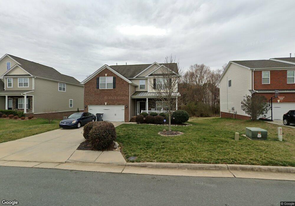
2011 Heron Pointe Dr Whitsett, NC 27377
Estimated Value: $372,601 - $545,000
4
Beds
3
Baths
2,766
Sq Ft
$158/Sq Ft
Est. Value
About This Home
This home is located at 2011 Heron Pointe Dr, Whitsett, NC 27377 and is currently estimated at $437,900, approximately $158 per square foot. 2011 Heron Pointe Dr is a home with nearby schools including Sedalia Elementary School, Eastern Guilford Middle School, and Eastern Guilford High School.
Ownership History
Date
Name
Owned For
Owner Type
Purchase Details
Closed on
Jun 1, 2021
Sold by
Evans James
Bought by
Evans James and Ford Marla Maria
Current Estimated Value
Purchase Details
Closed on
Sep 3, 2020
Sold by
Evans James
Bought by
Evans James and Ford Marla Maria
Purchase Details
Closed on
Mar 27, 2015
Sold by
Keystone Group Inc
Bought by
Evans James
Home Financials for this Owner
Home Financials are based on the most recent Mortgage that was taken out on this home.
Original Mortgage
$245,635
Outstanding Balance
$189,438
Interest Rate
3.79%
Mortgage Type
VA
Estimated Equity
$248,462
Purchase Details
Closed on
Jul 1, 2011
Bought by
Keystone Group Inc
Create a Home Valuation Report for This Property
The Home Valuation Report is an in-depth analysis detailing your home's value as well as a comparison with similar homes in the area
Home Values in the Area
Average Home Value in this Area
Purchase History
| Date | Buyer | Sale Price | Title Company |
|---|---|---|---|
| Evans James | -- | None Available | |
| Evans James | -- | None Available | |
| Evans James | $240,500 | None Available | |
| Keystone Group Inc | -- | -- |
Source: Public Records
Mortgage History
| Date | Status | Borrower | Loan Amount |
|---|---|---|---|
| Open | Evans James | $245,635 |
Source: Public Records
Tax History
| Year | Tax Paid | Tax Assessment Tax Assessment Total Assessment is a certain percentage of the fair market value that is determined by local assessors to be the total taxable value of land and additions on the property. | Land | Improvement |
|---|---|---|---|---|
| 2025 | $2,363 | $291,500 | $48,000 | $243,500 |
| 2024 | $2,363 | $291,500 | $48,000 | $243,500 |
| 2023 | $2,363 | $291,500 | $48,000 | $243,500 |
| 2022 | $2,363 | $291,500 | $48,000 | $243,500 |
| 2021 | $1,895 | $233,800 | $35,000 | $198,800 |
| 2020 | $1,895 | $233,800 | $35,000 | $198,800 |
| 2019 | $1,895 | $233,800 | $0 | $0 |
| 2018 | $1,885 | $233,800 | $0 | $0 |
| 2017 | $1,885 | $233,800 | $0 | $0 |
| 2016 | $1,933 | $231,500 | $0 | $0 |
| 2015 | $294 | $35,000 | $0 | $0 |
| 2014 | $298 | $35,000 | $0 | $0 |
Source: Public Records
Map
Nearby Homes
- 6604 Barton Creek Ct
- 6548 Donahue Dr
- 1907b Whisper Lake Dr
- 1907 Whisper Lake Dr Unit B
- 1904 Brant Pointe Ct
- 1911 Whisper Lake Dr Unit A
- 1963 Whisper Lake Dr
- 2610 MacKintosh Lake Ln
- 1907 Northrop Dr
- 1161 Glory Vine Rd
- 1176 Brooksridge Way
- 1136 Rose Petal Way
- 1127 Oak Blossom Way
- 1174 Brooksridge Way
- 1112 Brooksridge Way
- 1108 Brooksridge Way
- 1274 Glory Vine Rd
- 1118 Glory Vine Rd
- 942 Boone Valley Rd
- 6415 Coral Vine Way
- 2013 Heron Pointe Dr
- 2009 Heron Pointe Dr
- 2007 Heron Pointe Dr
- 2015 Heron Pointe Dr
- 2015 Heron Point Dr
- 6718 Laurel Fork Dr
- 6715 Laurel Fork Dr
- 2005 Heron Pointe Dr
- 6619 Barton Creek Ct
- 2017 Heron Pointe Dr
- 2008 Heron Pointe Dr
- 6621 Barton Creek Ct
- 6713 Laurel Fork Dr
- 6615 Barton Creek Ct
- 6716 Laurel Fork Dr
- 6623 Barton Creek Ct
- 6613 Barton Creek Ct
- 2010 Heron Pointe Dr
- 2003 Heron Pointe Dr
- 2004 Heron Pointe Dr
Your Personal Tour Guide
Ask me questions while you tour the home.