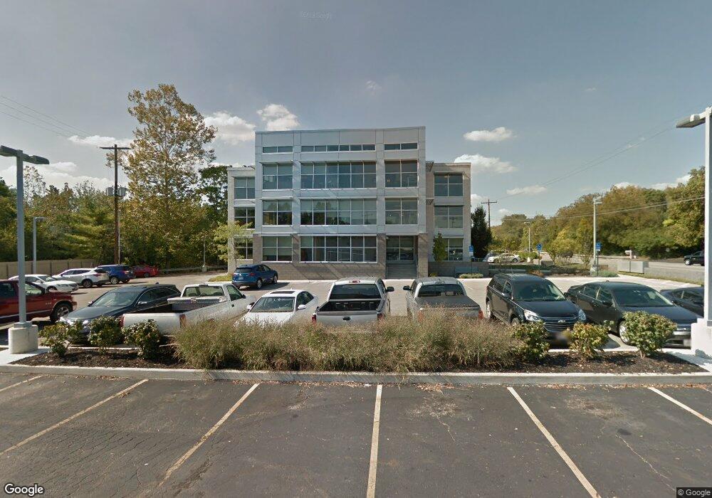
2011 Riverside Dr Columbus, OH 43221
Marble Cliff Crossing NeighborhoodEstimated Value: $946,921
Studio
--
Bath
14,000
Sq Ft
$68/Sq Ft
Est. Value
About This Home
This home is located at 2011 Riverside Dr, Columbus, OH 43221 and is currently estimated at $946,921, approximately $67 per square foot. 2011 Riverside Dr is a home located in Franklin County with nearby schools including Barrington Road Elementary School, Jones Middle School, and Upper Arlington High School.
Ownership History
Date
Name
Owned For
Owner Type
Purchase Details
Closed on
Apr 27, 2012
Sold by
Omega Properties
Bought by
Markota Llc
Current Estimated Value
Purchase Details
Closed on
Jun 22, 1988
Bought by
Omega Properties
Purchase Details
Closed on
Dec 11, 1987
Purchase Details
Closed on
Jun 1, 1987
Create a Home Valuation Report for This Property
The Home Valuation Report is an in-depth analysis detailing your home's value as well as a comparison with similar homes in the area
Home Values in the Area
Average Home Value in this Area
Purchase History
| Date | Buyer | Sale Price | Title Company |
|---|---|---|---|
| Markota Llc | $350,000 | None Available | |
| Omega Properties | $800,000 | -- | |
| -- | -- | -- | |
| -- | $302,000 | -- |
Source: Public Records
Tax History
| Year | Tax Paid | Tax Assessment Tax Assessment Total Assessment is a certain percentage of the fair market value that is determined by local assessors to be the total taxable value of land and additions on the property. | Land | Improvement |
|---|---|---|---|---|
| 2025 | $46,427 | $568,510 | $236,920 | $331,590 |
| 2024 | $46,427 | $568,510 | $236,920 | $331,590 |
| 2023 | $45,807 | $568,505 | $236,915 | $331,590 |
| 2022 | $33,566 | $375,380 | $78,190 | $297,190 |
| 2021 | $30,802 | $375,380 | $78,190 | $297,190 |
| 2020 | $30,556 | $375,380 | $78,190 | $297,190 |
| 2019 | $30,898 | $341,260 | $71,090 | $270,170 |
| 2018 | $27,512 | $341,260 | $71,090 | $270,170 |
| 2017 | $31,087 | $341,260 | $71,090 | $270,170 |
| 2016 | $28,701 | $330,130 | $71,090 | $259,040 |
| 2015 | $24,160 | $278,260 | $71,090 | $207,170 |
| 2014 | $10,557 | $122,510 | $71,090 | $51,420 |
| 2013 | $8,938 | $218,785 | $71,085 | $147,700 |
Source: Public Records
Map
Nearby Homes
- 2015 Hillside Dr
- 1960 Hillside Dr
- 1990 Lake Shore Dr
- 2150 Lane Woods Dr Unit 2150
- 2245 Riverside Dr Unit 309
- 2006 Cambridge Blvd
- 2151 Fairfax Rd
- 2208 Arlington Ave
- 2036 Beverly Rd
- 2842 Gunnison Dr Unit 402
- 2842 Gunnison Dr Unit 303
- 2842 Gunnison Dr Unit 203
- 2842 Gunnison Dr Unit 401
- 2842 Gunnison Dr Unit 201
- 2842 Gunnison Dr Unit 304
- 2842 Gunnison Dr Unit 202
- 2842 Gunnison Dr Unit 404
- 2842 Gunnison Dr Unit 204
- 2842 Gunnison Dr Unit 302
- 2842 Gunnison Dr Unit 301
- 1940 Scioto Pointe Dr Unit 1940
- 1940 Scioto Pointe Dr Unit D
- Lot 14 Scioto Pointe Dr
- 2019 Scioto Pointe Dr Unit 26
- 1805 Scioto Pointe Dr
- 1813 Scioto Pointe Dr
- 2088 Scioto Pointe Dr
- 2019 Scioto Pointe Dr
- 1821 Scioto Pointe Dr
- 1828 Scioto Pointe Dr
- 0 Scioto Pointe Dr Unit 14 2751016
- 0 Scioto Pointe Dr Unit L-15 9833146
- 0 Scioto Pointe Dr Unit L-25 9833143
- 0 Scioto Pointe Dr Unit 16 & 17 2723617
- 0 Scioto Pointe Dr Unit 2615932
- 0 Scioto Pointe Dr Unit LOT11 2546773
- 0 Scioto Pointe Dr Unit 17 9830009
- 0 Scioto Pointe Dr Unit 9830005
- 0 Scioto Pointe Dr Unit 12 9830006
- 0 Scioto Pointe Dr Unit 9912865
Your Personal Tour Guide
Ask me questions while you tour the home.