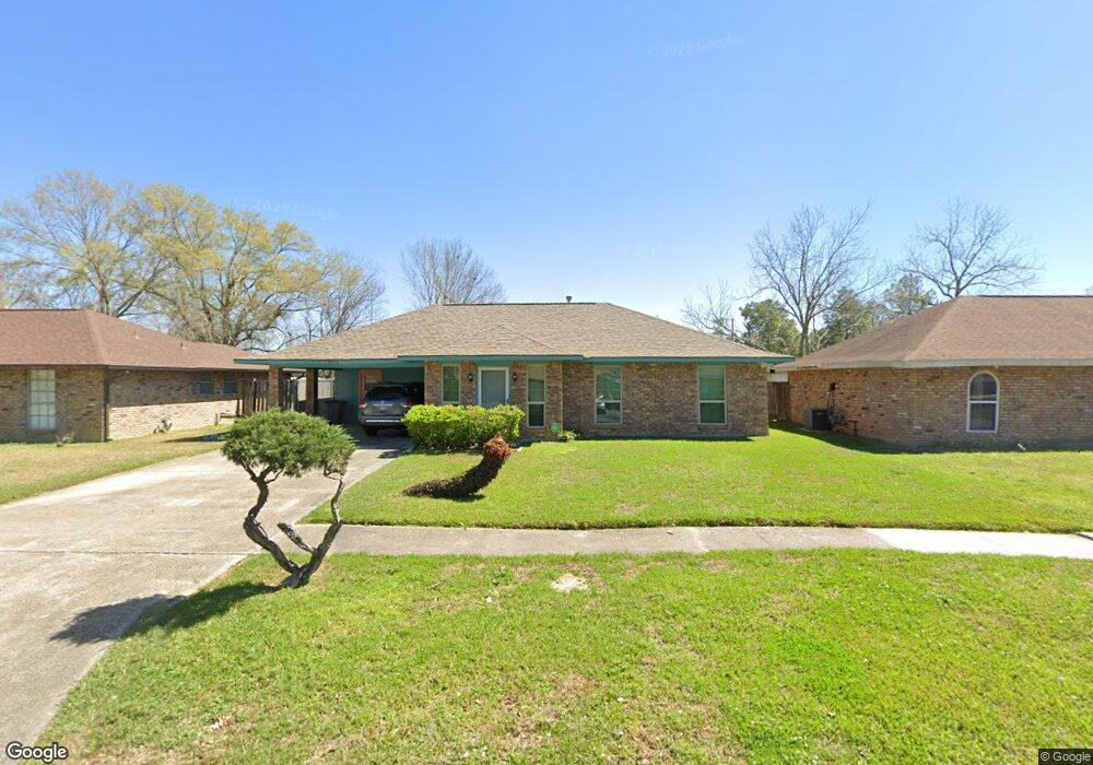
2012 Vickers Dr Baton Rouge, LA 70815
Park Forest/LA North NeighborhoodEstimated Value: $135,835 - $167,000
3
Beds
2
Baths
1,324
Sq Ft
$118/Sq Ft
Est. Value
About This Home
This home is located at 2012 Vickers Dr, Baton Rouge, LA 70815 and is currently estimated at $156,459, approximately $118 per square foot. 2012 Vickers Dr is a home located in East Baton Rouge Parish with nearby schools including LaBelle Aire Elementary School, Park Forest Middle School, and Belaire High School.
Ownership History
Date
Name
Owned For
Owner Type
Purchase Details
Closed on
Jan 29, 1999
Sold by
Johnson Kala Shaw Lucius Usuf and Johnson Mark Steven
Bought by
Robinson Victor R and Robinson Marilyn Johnson
Current Estimated Value
Home Financials for this Owner
Home Financials are based on the most recent Mortgage that was taken out on this home.
Original Mortgage
$68,916
Outstanding Balance
$16,382
Interest Rate
6.79%
Mortgage Type
FHA
Estimated Equity
$140,077
Create a Home Valuation Report for This Property
The Home Valuation Report is an in-depth analysis detailing your home's value as well as a comparison with similar homes in the area
Home Values in the Area
Average Home Value in this Area
Purchase History
| Date | Buyer | Sale Price | Title Company |
|---|---|---|---|
| Robinson Victor R | $69,000 | -- |
Source: Public Records
Mortgage History
| Date | Status | Borrower | Loan Amount |
|---|---|---|---|
| Open | Robinson Victor R | $68,916 |
Source: Public Records
Tax History
| Year | Tax Paid | Tax Assessment Tax Assessment Total Assessment is a certain percentage of the fair market value that is determined by local assessors to be the total taxable value of land and additions on the property. | Land | Improvement |
|---|---|---|---|---|
| 2024 | $786 | $11,390 | $1,200 | $10,190 |
| 2023 | $720 | $9,400 | $1,200 | $8,200 |
| 2022 | $1,297 | $9,400 | $1,200 | $8,200 |
| 2021 | $1,272 | $9,400 | $1,200 | $8,200 |
| 2020 | $1,110 | $9,400 | $1,200 | $8,200 |
| 2019 | $1,161 | $9,400 | $1,200 | $8,200 |
| 2018 | $1,147 | $9,400 | $1,200 | $8,200 |
| 2017 | $1,147 | $9,400 | $1,200 | $8,200 |
| 2016 | $323 | $9,400 | $1,200 | $8,200 |
| 2015 | $242 | $8,700 | $1,200 | $7,500 |
| 2014 | $241 | $8,700 | $1,200 | $7,500 |
| 2013 | -- | $8,700 | $1,200 | $7,500 |
Source: Public Records
Map
Nearby Homes
- 2046 Oak Grove Dr
- 2217 N Little John Dr
- 2148 Oak Knoll Dr
- 12366 Warfield Ave
- 1345 Cristy Dr
- 12329 Lorna Ave
- 12360 Robbie Ave
- 11543 Glenda Dr
- 11370 E Black Oak Dr
- 3825 N Sherwood Forest Dr
- 1466 Harco Dr
- 11225 Chalice Dr
- 1435 Duchess Dr
- 1184 Harco Dr
- 1454 - 1456 Gwen Dr
- 1634 Windsor Dr
- 11106 Black Oak Dr
- 11625 Archery Dr
- 323 Little John Dr
- 11054 Red Oak Dr
- 2026 Vickers Dr
- 2004 Vickers Dr
- 2038 Vickers Dr
- 2011 Vickers Dr
- 2023 Vickers Dr
- 2042 Vickers Dr
- 2005 Vickers Dr
- 2035 Vickers Dr
- 2056 Vickers Dr
- 2041 Vickers Dr
- 11906 Tams Dr
- 2014 Shady Oaks Dr
- 2026 Shady Oaks Dr
- 2002 Shady Oaks Dr
- 2055 Vickers Dr
- 2102 Vickers Dr
- 2038 Shady Oaks Dr
- 11868 Tams Dr
- 2044 Shady Oaks Dr
- 1527 Tamari Dr
Your Personal Tour Guide
Ask me questions while you tour the home.