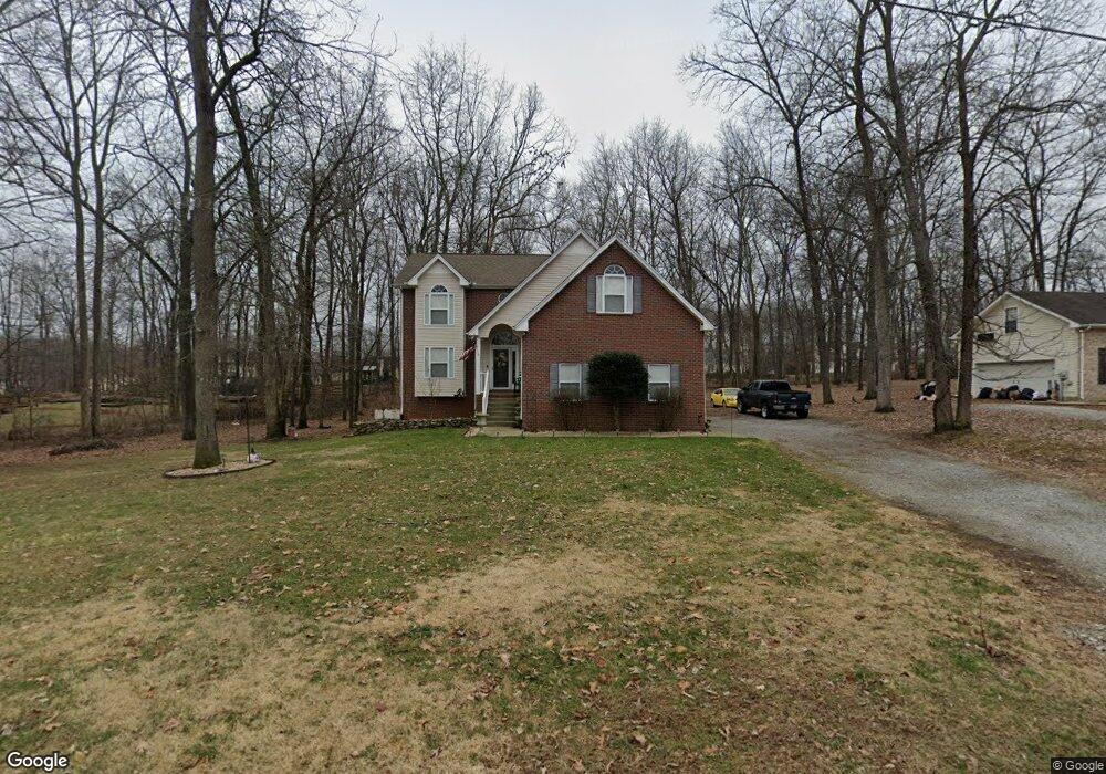
2013 Apollo Dr White House, TN 37188
Estimated Value: $364,515 - $484,000
--
Bed
3
Baths
1,905
Sq Ft
$231/Sq Ft
Est. Value
About This Home
This home is located at 2013 Apollo Dr, White House, TN 37188 and is currently estimated at $439,379, approximately $230 per square foot. 2013 Apollo Dr is a home located in Robertson County with nearby schools including Robert F. Woodall Elementary School, White House Heritage Elementary School, and White House Heritage High School.
Ownership History
Date
Name
Owned For
Owner Type
Purchase Details
Closed on
Aug 21, 2006
Sold by
Stanfield Robert A
Bought by
Stanfield Robert A
Current Estimated Value
Purchase Details
Closed on
Jul 7, 2004
Sold by
Adams Construction And Int
Bought by
Stanfield Robert A and Stanfield Terri L
Home Financials for this Owner
Home Financials are based on the most recent Mortgage that was taken out on this home.
Original Mortgage
$186,920
Interest Rate
6.25%
Purchase Details
Closed on
Mar 12, 2004
Sold by
Lord Herbert S
Bought by
Adams Construction & Interiors
Create a Home Valuation Report for This Property
The Home Valuation Report is an in-depth analysis detailing your home's value as well as a comparison with similar homes in the area
Home Values in the Area
Average Home Value in this Area
Purchase History
| Date | Buyer | Sale Price | Title Company |
|---|---|---|---|
| Stanfield Robert A | -- | -- | |
| Stanfield Robert A | $186,923 | -- | |
| Adams Construction & Interiors | $28,900 | -- |
Source: Public Records
Mortgage History
| Date | Status | Borrower | Loan Amount |
|---|---|---|---|
| Open | Adams Construction & Interiors | $226,770 | |
| Previous Owner | Adams Construction & Interiors | $186,920 |
Source: Public Records
Tax History Compared to Growth
Tax History
| Year | Tax Paid | Tax Assessment Tax Assessment Total Assessment is a certain percentage of the fair market value that is determined by local assessors to be the total taxable value of land and additions on the property. | Land | Improvement |
|---|---|---|---|---|
| 2024 | $1,449 | $80,500 | $14,100 | $66,400 |
| 2023 | $1,449 | $80,500 | $14,100 | $66,400 |
| 2022 | $1,368 | $53,100 | $6,750 | $46,350 |
| 2021 | $1,368 | $53,100 | $6,750 | $46,350 |
| 2020 | $1,368 | $53,100 | $6,750 | $46,350 |
| 2019 | $1,368 | $53,100 | $6,750 | $46,350 |
| 2018 | $1,368 | $53,100 | $6,750 | $46,350 |
| 2017 | $1,375 | $44,575 | $5,875 | $38,700 |
| 2016 | $1,375 | $44,575 | $5,875 | $38,700 |
| 2015 | $1,319 | $44,575 | $5,875 | $38,700 |
| 2014 | $1,319 | $44,575 | $5,875 | $38,700 |
Source: Public Records
Map
Nearby Homes
- 1336 Chelseas Way
- 2005 Skyhawk Ct
- 1044 Luton Way
- 3978 Bilbrey Dr
- 1033 Valleydale Ave
- 0 Calista Rd
- 1138 Melvin Dr
- 82 Deer Run Rd
- 1059 Melvin Dr
- 4359 Brownstone Dr
- 4037 Weston Dr
- 8481 Highway 25 E
- 8927 Covington Rd
- 8903 Covington Rd
- 8919 Covington Rd
- 4418 Westside Dr
- 9611 Cross Plains Rd
- 3390 Calista Rd
- 2023 Brokeshire Dr
- 1552 Hidden Meadow Dr
- 2007 Apollo Dr
- 1122 Archer Dr
- 0 Tbd Socata Ct
- 0 Neill Lane Lot 26
- 0 Neill Lane Lot 10 Unit 2221533
- 2012 Apollo Dr
- 4015 Socata Ct
- 2008 Apollo Dr
- 2003 Apollo Dr
- 2016 Apollo Dr
- 4009 Socata Ct
- 4019 Socata Ct
- 1114 Archer Dr
- 4049 Socata Ct
- 4025 Socata Ct
- 2022 Apollo Dr
- 2025 Apollo Dr
- 1117 Archer Dr
- 4425 Socata Ct
- 4125 Socata Ct