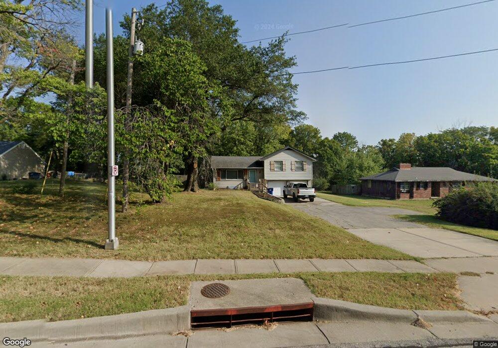
2014 NW Chipman Rd Lees Summit, MO 64081
Estimated Value: $259,000 - $315,000
3
Beds
1
Bath
1,182
Sq Ft
$239/Sq Ft
Est. Value
About This Home
This home is located at 2014 NW Chipman Rd, Lees Summit, MO 64081 and is currently estimated at $283,056, approximately $239 per square foot. 2014 NW Chipman Rd is a home located in Jackson County with nearby schools including Cedar Creek Elementary School, Bernard C. Campbell Middle School, and Lee's Summit North High School.
Ownership History
Date
Name
Owned For
Owner Type
Purchase Details
Closed on
Jul 6, 2020
Sold by
Wilde Heather L and Wilde Joseph
Bought by
Summit Property Investors Llc
Current Estimated Value
Purchase Details
Closed on
May 14, 2020
Sold by
Wilde Heather L
Bought by
Wilde Heather L
Purchase Details
Closed on
Apr 11, 2012
Sold by
Shaw William K and Revocab Patricia
Bought by
Shaw Patricia L and Wilde Heather L
Purchase Details
Closed on
Mar 19, 1996
Sold by
Shaw William K and Shaw Patricia L
Bought by
Shaw William K and Shaw Patricia L
Create a Home Valuation Report for This Property
The Home Valuation Report is an in-depth analysis detailing your home's value as well as a comparison with similar homes in the area
Home Values in the Area
Average Home Value in this Area
Purchase History
| Date | Buyer | Sale Price | Title Company |
|---|---|---|---|
| Summit Property Investors Llc | -- | Alpha | |
| Wilde Heather L | -- | None Available | |
| Shaw Patricia L | -- | None Available | |
| Shaw William K | -- | -- |
Source: Public Records
Tax History Compared to Growth
Tax History
| Year | Tax Paid | Tax Assessment Tax Assessment Total Assessment is a certain percentage of the fair market value that is determined by local assessors to be the total taxable value of land and additions on the property. | Land | Improvement |
|---|---|---|---|---|
| 2025 | $3,666 | $27,389 | $9,605 | $17,784 |
| 2024 | $3,666 | $50,768 | $8,552 | $42,216 |
| 2023 | $3,639 | $50,768 | $8,552 | $42,216 |
| 2022 | $1,672 | $20,710 | $3,361 | $17,349 |
| 2021 | $1,706 | $20,710 | $3,361 | $17,349 |
| 2020 | $1,510 | $18,143 | $3,361 | $14,782 |
| 2019 | $1,468 | $18,143 | $3,361 | $14,782 |
| 2018 | $1,377 | $15,790 | $2,925 | $12,865 |
| 2017 | $1,377 | $15,790 | $2,925 | $12,865 |
| 2016 | $1,356 | $15,394 | $2,808 | $12,586 |
| 2014 | $1,384 | $15,394 | $2,808 | $12,586 |
Source: Public Records
Map
Nearby Homes
- 2007 NW Chipman Rd
- 2209 NW Wellington Ct
- 2122 NW Ashurst Dr
- 2110 NW Ashurst Dr
- 130 NW Ambersham Dr
- 505 NW Ambersham Dr
- 2257 NW Summerfield Dr
- 813 NW High Point Dr
- 2086 NW O'Brien Rd
- 2090 NW O'Brien Rd
- The Wydnham II Plan at Reserve at Woodside Ridge - Reserve
- The Timberland Reverse Plan at Reserve at Woodside Ridge - Reserve
- The Timberland Expanded Plan at Reserve at Woodside Ridge - Reserve
- The Tatum Plan at Reserve at Woodside Ridge - Reserve
- The Sierra V Plan at Reserve at Woodside Ridge - Reserve
- The Sierra IV Plan at Reserve at Woodside Ridge - Reserve
- The Sierra II Plan at Reserve at Woodside Ridge - Reserve
- The Scottsdale Reverse Plan at Reserve at Woodside Ridge - Reserve
- The Scottsdale Plan at Reserve at Woodside Ridge - Reserve
- The Rebecca Plan at Reserve at Woodside Ridge - Reserve
- 2010 NW Chipman Rd
- 2016 NW Chipman Rd
- 2020 NW Chipman Rd
- 2009 NW Chipman Rd
- 2013 NW Chipman Rd
- 2011 NW Chipman Rd
- 2100 NW Chipman Rd
- 660 NW Brookhaven Dr
- 661 NW Brookhaven Dr
- 656 NW Brookhaven Dr
- 657 NW Brookhaven Dr
- 2102 NW Chipman Rd
- 652 NW Brookhaven Dr
- 653 NW Brookhaven Dr
- 2001 NW Chipman Rd
- 648 NW Brookhaven Dr
- 649 NW Brookhaven Dr
- 1915 NW Chipman Rd Unit A
- 2204 NW Wellington Ct
- 2200 NW Wellington Ct