
20140 Highway 62 Shady Cove, OR 97539
Estimated payment $416/month
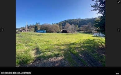
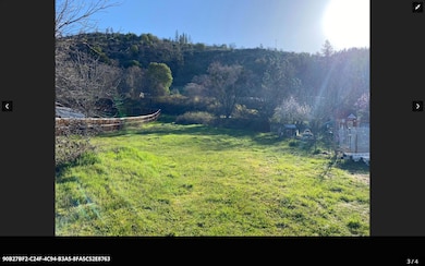
About This Lot
Nice gently sloping residential lot on the outskirts of Shady Cove . Electricity and city sewer are at the property line. Per the owners, the property has been witched for water twice, with two good locations being noted, buyer to do their own due diligence on property usage and water location. This property is not in the Shady Meadows subdivision, there are no other options for subdivision names, that is a place holder, this property is not in a subdivision.
Property Details
Property Type
- Land
Est. Annual Taxes
- $738
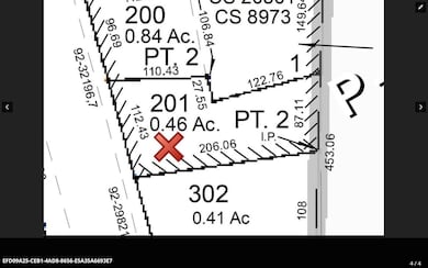
Lot Details
- 0.46 Acre Lot
- Property is zoned R-1-20, R-1-20
Schools
- Shady Cove Elementary And Middle School
- Eagle Point High School
Mobile Home
- Mobile Home Allowed
Utilities
- Phone Available
- Cable TV Available
Community Details
- No Home Owners Association
- Shady Meadows Tract Unit No I Subdivision
Listing and Financial Details
- Tax Lot 201
- Assessor Parcel Number 1-0992956
Map
Home Values in the Area
Average Home Value in this Area
Tax History
| Year | Tax Paid | Tax Assessment Tax Assessment Total Assessment is a certain percentage of the fair market value that is determined by local assessors to be the total taxable value of land and additions on the property. | Land | Improvement |
|---|---|---|---|---|
| 2025 | $822 | $69,080 | $69,080 | -- |
| 2024 | $822 | $67,070 | $67,070 | -- |
| 2023 | $800 | $65,120 | $65,120 | $0 |
| 2022 | $761 | $65,120 | $65,120 | $0 |
| 2021 | $738 | $63,230 | $63,230 | $0 |
| 2020 | $795 | $61,390 | $61,390 | $0 |
| 2019 | $785 | $57,880 | $57,880 | $0 |
| 2018 | $829 | $56,200 | $56,200 | $0 |
| 2017 | $713 | $56,200 | $56,200 | $0 |
| 2016 | $696 | $53,460 | $53,460 | $0 |
| 2015 | $675 | $53,460 | $53,460 | $0 |
| 2014 | $654 | $50,400 | $50,400 | $0 |
Property History
| Date | Event | Price | List to Sale | Price per Sq Ft | Prior Sale |
|---|---|---|---|---|---|
| 10/07/2025 10/07/25 | Price Changed | $67,500 | -14.5% | -- | |
| 07/24/2023 07/24/23 | Price Changed | $78,950 | -1.3% | -- | |
| 01/09/2023 01/09/23 | Price Changed | $79,950 | -5.8% | -- | |
| 09/06/2022 09/06/22 | Price Changed | $84,900 | -5.6% | -- | |
| 03/31/2022 03/31/22 | For Sale | $89,900 | +19.9% | -- | |
| 12/09/2021 12/09/21 | Sold | $75,000 | -11.8% | -- | View Prior Sale |
| 07/09/2021 07/09/21 | Pending | -- | -- | -- | |
| 04/06/2021 04/06/21 | For Sale | $85,000 | -- | -- |
Purchase History
| Date | Type | Sale Price | Title Company |
|---|---|---|---|
| Warranty Deed | $75,000 | First American |
Source: Oregon Datashare
MLS Number: 220142277
APN: 10992956
Disclaimer: Certain information contained herein is derived from information provided by parties other than Homes.com. All information provided is deemed reliable, but is not guaranteed to be accurate and should be independently verified.
![]() © 2025 Oregon Datashare (KCAR | MLSCO | SOMLS). All rights reserved. The data relating to real estate for sale on this web site comes in part from the Internet Data Exchange Program of the Oregon Datashare. Real estate listings held by IDX Brokerage firms other than Ten-X are marked with the Internet Data Exchange logo or the Internet Data Exchange thumbnail logo and detailed information about them includes the name of the listing Brokers. Information provided is for consumers' personal, non-commercial use and may not be used for any purpose other than to identify prospective properties the viewer may be interested in purchasing. The consumer will not copy, retransmit nor redistribute any of the content from this website. Information provided is deemed reliable, but not guaranteed.
© 2025 Oregon Datashare (KCAR | MLSCO | SOMLS). All rights reserved. The data relating to real estate for sale on this web site comes in part from the Internet Data Exchange Program of the Oregon Datashare. Real estate listings held by IDX Brokerage firms other than Ten-X are marked with the Internet Data Exchange logo or the Internet Data Exchange thumbnail logo and detailed information about them includes the name of the listing Brokers. Information provided is for consumers' personal, non-commercial use and may not be used for any purpose other than to identify prospective properties the viewer may be interested in purchasing. The consumer will not copy, retransmit nor redistribute any of the content from this website. Information provided is deemed reliable, but not guaranteed.
- 20400 Highway 62
- 20055 Oregon 62 Unit 42
- 21 Brophy Way Unit 17
- 20455 Highway 62
- 20413 Oregon 62
- 192 Cindy Way
- 176 Cindy Way
- 332 Rene Dr
- 78 Maple Dr
- 330 Penny Ln
- 6400 Rogue River Dr
- 2450 Indian Creek Rd
- 0 Cabetowne Way Unit 220200666
- 7266 Rogue River Dr
- 218 Long Branch Rd
- 103 Summit Dr
- 363 Kitty Dr
- 58 Pine St
- 470 Old Ferry Rd
- 1090 Anglers Place
- 228 Teakwood Dr
- 396 Patricia Ln
- 451 Broad St
- 451 Broad St Unit Garden View
- 6356 Ventura Ln
- 107 Applewood Dr
- 700 N Haskell St
- 459 4th Ave
- 2190 Poplar Dr
- 1801 Poplar Dr
- 237 E McAndrews Rd
- 645 Royal Ave
- 518 N Riverside Ave
- 406 W Main St
- 121 S Holly St
- 2642 W Main St
- 309 Laurel St
- 835 Overcup St
- 534 Hamilton St Unit 534
- 2532 Juanipero Way
