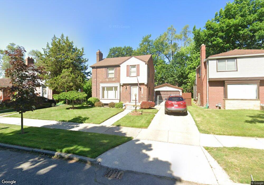
20143 Snowden St Detroit, MI 48235
Blackstone Park NeighborhoodEstimated Value: $101,000 - $145,000
--
Bed
1
Bath
1,308
Sq Ft
$93/Sq Ft
Est. Value
About This Home
This home is located at 20143 Snowden St, Detroit, MI 48235 and is currently estimated at $122,187, approximately $93 per square foot. 20143 Snowden St is a home located in Wayne County with nearby schools including Vernor Elementary School, Charles L. Spain Elementary-Middle School, and Edward 'Duke' Ellington Conservatory of Music and Art.
Ownership History
Date
Name
Owned For
Owner Type
Purchase Details
Closed on
Dec 26, 2014
Sold by
Graves Brenda J and Ray Brenda J
Bought by
Ray Brenda J
Current Estimated Value
Home Financials for this Owner
Home Financials are based on the most recent Mortgage that was taken out on this home.
Original Mortgage
$54,000
Interest Rate
3.11%
Mortgage Type
Reverse Mortgage Home Equity Conversion Mortgage
Create a Home Valuation Report for This Property
The Home Valuation Report is an in-depth analysis detailing your home's value as well as a comparison with similar homes in the area
Home Values in the Area
Average Home Value in this Area
Purchase History
| Date | Buyer | Sale Price | Title Company |
|---|---|---|---|
| Ray Brenda J | -- | Liberty Title |
Source: Public Records
Mortgage History
| Date | Status | Borrower | Loan Amount |
|---|---|---|---|
| Closed | Ray Brenda J | $54,000 |
Source: Public Records
Tax History Compared to Growth
Tax History
| Year | Tax Paid | Tax Assessment Tax Assessment Total Assessment is a certain percentage of the fair market value that is determined by local assessors to be the total taxable value of land and additions on the property. | Land | Improvement |
|---|---|---|---|---|
| 2025 | $1,315 | $51,600 | $0 | $0 |
| 2024 | $1,315 | $45,200 | $0 | $0 |
| 2023 | $1,276 | $36,900 | $0 | $0 |
| 2022 | $1,398 | $32,500 | $0 | $0 |
| 2021 | $1,363 | $26,200 | $0 | $0 |
| 2020 | $1,348 | $23,900 | $0 | $0 |
| 2019 | $1,327 | $17,800 | $0 | $0 |
| 2018 | $1,128 | $15,100 | $0 | $0 |
| 2017 | $298 | $15,700 | $0 | $0 |
| 2016 | $1,465 | $20,300 | $0 | $0 |
| 2015 | $2,030 | $20,300 | $0 | $0 |
| 2013 | $2,922 | $29,829 | $0 | $0 |
| 2010 | -- | $43,732 | $1,094 | $42,638 |
Source: Public Records
Map
Nearby Homes
- 20124 Snowden St
- 20196 Hartwell St
- 20150 Schaefer Hwy
- 20108 Cheyenne St
- 20129 Ward St
- 20167 Ward St
- 19978 Tracey St
- 19909 Hartwell St
- 19925 Schaefer Hwy
- 20110 Lesure St
- 20184 Ward St
- 20426 Tracey St
- 13517 Pembroke Ave
- 20242 Ward St
- 20475 Tracey St
- 20032 Stansbury St
- 19744 Snowden St
- 19744 Littlefield St
- 19721 Hartwell St
- 19733 Schaefer Hwy
- 20151 Snowden St
- 20135 Snowden St
- 20161 Snowden St
- 20125 Snowden St
- 20144 Hartwell St Unit Bldg-Unit
- 20144 Hartwell St
- 20136 Hartwell St
- 20152 Hartwell St
- 20128 Hartwell St
- 20113 Snowden St
- 20169 Snowden St
- 20120 Hartwell St
- 20177 Snowden St
- 20168 Hartwell St
- 20144 Snowden St
- 20134 Snowden St
- 20156 Snowden St
- 20114 Snowden St
- 20112 Hartwell St
- 20176 Hartwell St