Estimated Value: $618,528 - $655,000
3
Beds
3
Baths
1,801
Sq Ft
$354/Sq Ft
Est. Value
About This Home
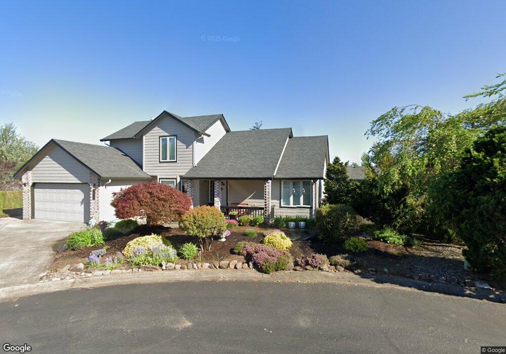
This home is located at 2015 NW 30th Cir, Camas, WA 98607 and is currently estimated at $637,882, approximately $354 per square foot. 2015 NW 30th Cir is a home located in Clark County with nearby schools including Dorothy Fox Elementary School, Skyridge Middle School, and Camas High School.
Ownership History
Date
Name
Owned For
Owner Type
Purchase Details
Closed on
Feb 11, 2025
Sold by
Wiencken Carrie Lynn and Wiencken John G
Bought by
John G Wiencken Decedents Trust and Wienken
Current Estimated Value
Purchase Details
Closed on
Jul 25, 2022
Sold by
Lynn Wiencken Carrie
Bought by
Wiencken John G and Wiencken Carrie Lynn
Purchase Details
Closed on
Jan 10, 2000
Sold by
Thomas John D and Newell Linda M
Bought by
Wiencken Carrie Lynn
Purchase Details
Closed on
Jun 9, 1995
Sold by
Karlsen Timothy and Karlsen Carol
Bought by
Thomas John D and Newell Linda M
Home Financials for this Owner
Home Financials are based on the most recent Mortgage that was taken out on this home.
Original Mortgage
$158,400
Interest Rate
8.36%
Mortgage Type
Assumption
Purchase Details
Closed on
Jan 25, 1995
Sold by
Tbws Partnership and Smick Martin Skylar
Bought by
Karlsen Timothy and Karlsen Carol
Create a Home Valuation Report for This Property
The Home Valuation Report is an in-depth analysis detailing your home's value as well as a comparison with similar homes in the area
Home Values in the Area
Average Home Value in this Area
Purchase History
| Date | Buyer | Sale Price | Title Company |
|---|---|---|---|
| John G Wiencken Decedents Trust | $313 | None Listed On Document | |
| Wiencken John G | -- | None Listed On Document | |
| Wiencken Carrie Lynn | -- | Washington Title Company | |
| Thomas John D | $153,839 | Chicago Title Insurance Co | |
| Karlsen Timothy | $36,500 | Clark County Title Company |
Source: Public Records
Mortgage History
| Date | Status | Borrower | Loan Amount |
|---|---|---|---|
| Previous Owner | Thomas John D | $158,400 |
Source: Public Records
Tax History Compared to Growth
Tax History
| Year | Tax Paid | Tax Assessment Tax Assessment Total Assessment is a certain percentage of the fair market value that is determined by local assessors to be the total taxable value of land and additions on the property. | Land | Improvement |
|---|---|---|---|---|
| 2025 | $5,277 | $475,000 | $175,000 | $300,000 |
| 2024 | $4,721 | $553,482 | $274,000 | $279,482 |
| 2023 | $4,660 | $532,193 | $241,000 | $291,193 |
| 2022 | $4,695 | $499,614 | $226,150 | $273,464 |
| 2021 | $4,569 | $420,801 | $191,500 | $229,301 |
| 2020 | $4,819 | $379,571 | $175,000 | $204,571 |
| 2019 | $4,522 | $371,263 | $175,000 | $196,263 |
| 2018 | $4,585 | $371,135 | $0 | $0 |
| 2017 | $4,316 | $316,284 | $0 | $0 |
| 2016 | $3,863 | $324,233 | $0 | $0 |
| 2015 | $3,979 | $288,755 | $0 | $0 |
| 2014 | -- | $280,403 | $0 | $0 |
| 2013 | -- | $244,323 | $0 | $0 |
Source: Public Records
Map
Nearby Homes
- 3313 NW Sierra Dr
- 3015 NW Vanguard Place
- 1610 NW 34th Ave
- 1402 NW 30th Ave
- 2316 NW 26th Ave
- 2645 NW 29th Ave
- 2711 NW 28th Cir
- 2720 NW 30th Cir
- 2609 NW Cascade St
- 2955 NW Dahlia Dr
- 2112 NW 42nd Ave
- 4000 NW Dahlia Dr
- 4030 NW Dahlia Dr
- 3113 NW Pacific Rim Dr
- 2530 NW 22nd Ave
- 2012 NW Willow Dr
- 1146 NW 23rd Ave Unit A1
- 3367 NW 31st Cir
- 2107 NW Douglas St
- 1911 NW Astor Ct
- 2003 NW 30th Cir
- 2018 NW 31st Ave
- 2002 NW 31st Ave
- 2014 NW 30th Cir
- 1941 NW 30th Cir
- 1952 NW 30th Cir
- 2110 NW 31st Cir
- 1940 NW 31st Ave
- 2019 NW 31st Ave
- 2005 NW 31st Ave
- 2108 NW 30th Cir
- 1925 NW 30th Cir
- 2107 NW 31st Cir
- 2126 NW 31st Cir
- 2911 NW Sierra Place
- 1930 NW 30th Cir
- 2125 NW 30th Cir
- 1943 NW 31st Ave
- 1926 NW 31st Ave
- 2103 NW 29th Cir