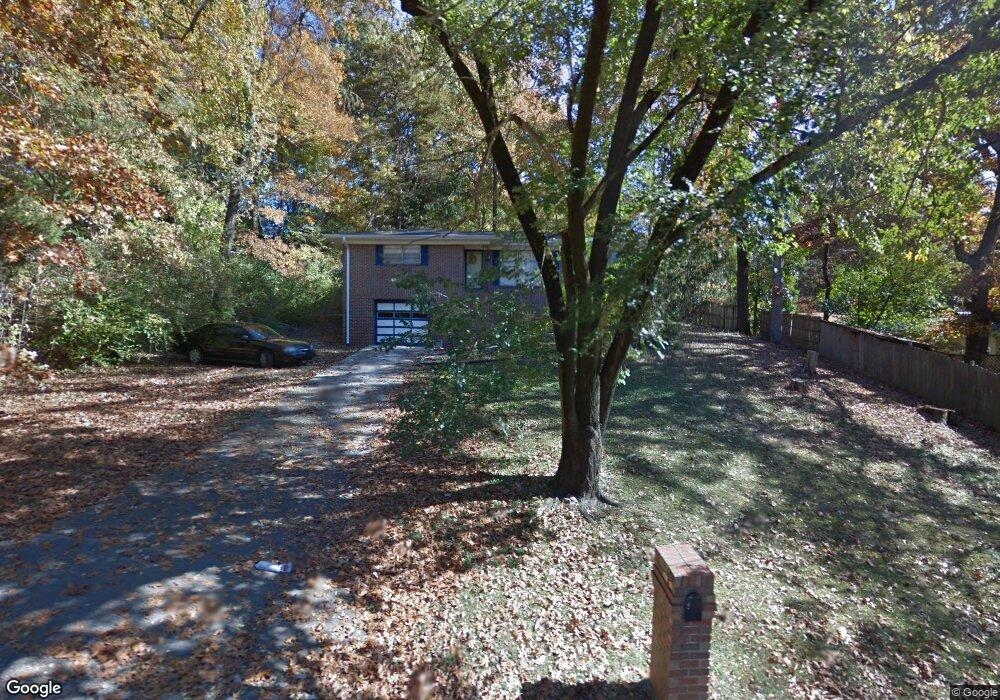
2015 Pershing Rd Birmingham, AL 35214
Estimated Value: $123,000 - $184,000
3
Beds
1
Bath
1,324
Sq Ft
$113/Sq Ft
Est. Value
About This Home
This home is located at 2015 Pershing Rd, Birmingham, AL 35214 and is currently estimated at $150,214, approximately $113 per square foot. 2015 Pershing Rd is a home located in Jefferson County with nearby schools including Minor Middle School, Minor High School, and Gloryland Christian Academy.
Ownership History
Date
Name
Owned For
Owner Type
Purchase Details
Closed on
Jul 17, 2000
Sold by
Douglas Carter Judd
Bought by
Wilkerson Ednalene S
Current Estimated Value
Home Financials for this Owner
Home Financials are based on the most recent Mortgage that was taken out on this home.
Original Mortgage
$66,883
Outstanding Balance
$23,596
Interest Rate
8.23%
Mortgage Type
FHA
Estimated Equity
$126,618
Create a Home Valuation Report for This Property
The Home Valuation Report is an in-depth analysis detailing your home's value as well as a comparison with similar homes in the area
Home Values in the Area
Average Home Value in this Area
Purchase History
| Date | Buyer | Sale Price | Title Company |
|---|---|---|---|
| Wilkerson Ednalene S | $68,000 | -- | |
| Carter Judd Douglas | $1,000 | -- | |
| Carter Judd Douglas | $1,000 | -- | |
| Carter Judd Douglas | $1,000 | -- | |
| Carter Judd Douglas | $1,000 | -- |
Source: Public Records
Mortgage History
| Date | Status | Borrower | Loan Amount |
|---|---|---|---|
| Open | Carter Judd Douglas | $66,883 |
Source: Public Records
Tax History
| Year | Tax Paid | Tax Assessment Tax Assessment Total Assessment is a certain percentage of the fair market value that is determined by local assessors to be the total taxable value of land and additions on the property. | Land | Improvement |
|---|---|---|---|---|
| 2024 | $441 | $10,740 | -- | -- |
| 2023 | $321 | $10,740 | $2,056 | $8,684 |
| 2022 | $441 | $10,730 | $2,650 | $8,080 |
| 2021 | $485 | $10,730 | $2,650 | $8,080 |
| 2020 | $485 | $10,730 | $2,650 | $8,080 |
| 2019 | $485 | $10,740 | $0 | $0 |
| 2018 | $411 | $9,260 | $0 | $0 |
| 2017 | $411 | $9,260 | $0 | $0 |
| 2016 | $411 | $9,260 | $0 | $0 |
| 2015 | $411 | $9,260 | $0 | $0 |
| 2014 | $410 | $9,140 | $0 | $0 |
| 2013 | $410 | $9,140 | $0 | $0 |
Source: Public Records
Map
Nearby Homes
- 460 Roseta Dr
- 2036 Pershing Rd
- 539 Crumly Chapel Rd
- 2361 Pershing Place Loop
- 2352 Pershing Place Loop
- 228 Gober Dr
- 525 Crumley Chapel Rd
- 2150 & 2140 Veterans Memorial Dr
- 1900 Hanchey Rd
- 1744 Pratt Hwy
- 2349 Pershing Rd
- 2345 Pershing Rd
- 2341 Pershing Rd
- 2151 Veterans Memorial Dr
- 409 Foust Ct
- 2108 Maywood Dr
- 2532 Forestdale Blvd
- 106 Merrywood Cir
- 2012 Arcadia Rd
- 133 Mulberry Rd
- 444 Roseta Dr
- 437 Cimmaron Dr
- 440 Roseta Dr
- 429 Cimmaron Dr
- 434 Roseta Dr
- 2012 Pershing Rd
- 444 Cimmaron Dr
- 2020 Pershing Rd
- 429 Roseta Dr
- 436 Cimmaron Dr
- 421 Cimmaron Dr
- 461 Roseta Dr
- 2028 Pershing Rd
- 428 Roseta Dr
- 428 Cimmaron Dr
- 2041 Pershing Rd
- 420 Cimmaron Dr
- 464 Roseta Dr
- 421 Roseta Dr
- 2040 Sunrise Rd
Your Personal Tour Guide
Ask me questions while you tour the home.