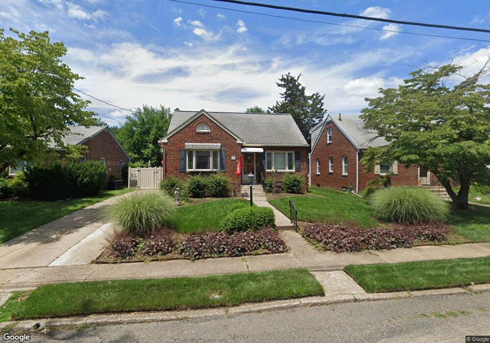
2015 W High St Haddon Heights, NJ 08035
Estimated Value: $344,000 - $358,000
--
Bed
--
Bath
872
Sq Ft
$402/Sq Ft
Est. Value
About This Home
This home is located at 2015 W High St, Haddon Heights, NJ 08035 and is currently estimated at $350,876, approximately $402 per square foot. 2015 W High St is a home located in Camden County with nearby schools including Haddon Heights Jr Sr High School and Saint Rose of Lima Catholic School.
Ownership History
Date
Name
Owned For
Owner Type
Purchase Details
Closed on
Feb 18, 2000
Sold by
Silvanio Diane M
Bought by
Lacey Charles M and Lacey Catherine M
Current Estimated Value
Home Financials for this Owner
Home Financials are based on the most recent Mortgage that was taken out on this home.
Original Mortgage
$90,250
Outstanding Balance
$30,009
Interest Rate
8.24%
Estimated Equity
$320,867
Create a Home Valuation Report for This Property
The Home Valuation Report is an in-depth analysis detailing your home's value as well as a comparison with similar homes in the area
Home Values in the Area
Average Home Value in this Area
Purchase History
| Date | Buyer | Sale Price | Title Company |
|---|---|---|---|
| Lacey Charles M | $95,000 | -- |
Source: Public Records
Mortgage History
| Date | Status | Borrower | Loan Amount |
|---|---|---|---|
| Open | Lacey Charles M | $90,250 |
Source: Public Records
Tax History Compared to Growth
Tax History
| Year | Tax Paid | Tax Assessment Tax Assessment Total Assessment is a certain percentage of the fair market value that is determined by local assessors to be the total taxable value of land and additions on the property. | Land | Improvement |
|---|---|---|---|---|
| 2025 | $7,485 | $217,600 | $95,000 | $122,600 |
| 2024 | $7,407 | $217,600 | $95,000 | $122,600 |
| 2023 | $7,407 | $217,600 | $95,000 | $122,600 |
| 2022 | $7,388 | $217,600 | $95,000 | $122,600 |
| 2021 | $7,366 | $217,600 | $95,000 | $122,600 |
| 2020 | $7,246 | $217,600 | $95,000 | $122,600 |
| 2019 | $7,124 | $217,600 | $95,000 | $122,600 |
| 2018 | $7,011 | $217,600 | $95,000 | $122,600 |
| 2017 | $6,826 | $217,600 | $95,000 | $122,600 |
| 2016 | $6,719 | $217,600 | $95,000 | $122,600 |
| 2015 | $6,580 | $217,600 | $95,000 | $122,600 |
| 2014 | $6,371 | $217,600 | $95,000 | $122,600 |
Source: Public Records
Map
Nearby Homes
- 2008 Sycamore St
- 1917 W High St
- 1915 Maple Ave
- 26 Wilson Ave
- 1600 W High St
- 1608 Prospect Ridge Blvd
- 420 Winthrop Ave
- 1528 Oak Ave
- 40 W Kings Hwy
- 102 Lincoln Ave
- 1517 Oak Ave
- 105 Lincoln Ave
- 1509 Chestnut Ave
- 539 W Kings Hwy
- 1501 Cedar Ave
- 17 W Buckingham Ave
- 54 W Browning Rd
- 1165 Fulling Mill Ln
- 26 S Oak Ave
- 143 Baird Ave
- 2019 W High St
- 2011 W High St
- 2025 W High St
- 2005 W High St
- 2014 Sycamore St
- 2029 W High St
- 2022 Sycamore St
- 2001 W High St
- 2004 Sycamore St
- 2012 W High St
- 2018 W High St
- 2008 W High St
- 2026 Sycamore St
- 2031 W High St
- 2022 W High St
- 2002 Sycamore St
- 2002 Sycamore St Unit Right side
- 2004 W High St
- 2000 Sycamore St
- 2026 W High St