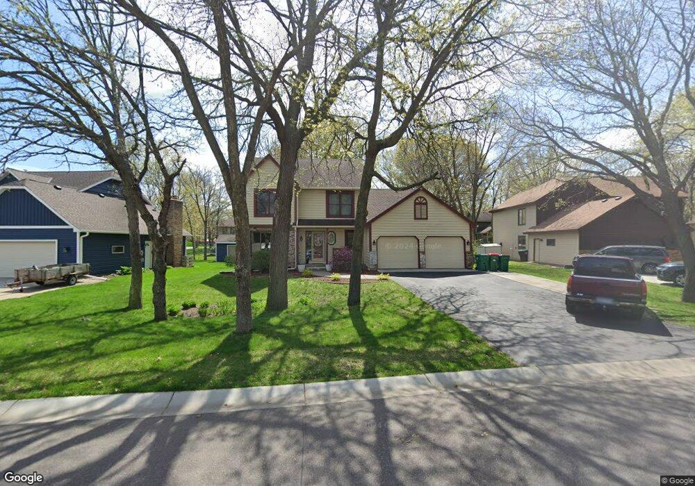
2016 128th Ave NW Coon Rapids, MN 55448
Estimated Value: $415,382 - $434,000
3
Beds
3
Baths
1,872
Sq Ft
$227/Sq Ft
Est. Value
About This Home
This home is located at 2016 128th Ave NW, Coon Rapids, MN 55448 and is currently estimated at $424,596, approximately $226 per square foot. 2016 128th Ave NW is a home located in Anoka County with nearby schools including Morris Bye Elementary School, Coon Rapids Middle School, and Coon Rapids Senior High School.
Ownership History
Date
Name
Owned For
Owner Type
Purchase Details
Closed on
Apr 15, 2010
Sold by
Hertog Ronald Leo
Bought by
Anderson Philip P and Anderson Corinne
Current Estimated Value
Purchase Details
Closed on
May 29, 2002
Sold by
Piper Barbara E and Piper John
Bought by
Hertog Ronald L and Hertog Kimberly K
Create a Home Valuation Report for This Property
The Home Valuation Report is an in-depth analysis detailing your home's value as well as a comparison with similar homes in the area
Home Values in the Area
Average Home Value in this Area
Purchase History
| Date | Buyer | Sale Price | Title Company |
|---|---|---|---|
| Anderson Philip P | $221,500 | -- | |
| Hertog Ronald L | $223,000 | -- |
Source: Public Records
Tax History
| Year | Tax Paid | Tax Assessment Tax Assessment Total Assessment is a certain percentage of the fair market value that is determined by local assessors to be the total taxable value of land and additions on the property. | Land | Improvement |
|---|---|---|---|---|
| 2025 | $4,565 | $418,200 | $90,000 | $328,200 |
| 2024 | $4,565 | $406,200 | $87,000 | $319,200 |
| 2023 | $4,237 | $395,500 | $72,000 | $323,500 |
| 2022 | $3,860 | $402,900 | $72,000 | $330,900 |
| 2021 | $3,488 | $323,600 | $56,000 | $267,600 |
| 2020 | $3,550 | $309,100 | $56,000 | $253,100 |
| 2019 | $3,457 | $301,700 | $56,000 | $245,700 |
| 2018 | $3,366 | $286,000 | $0 | $0 |
| 2017 | $3,089 | $270,700 | $0 | $0 |
| 2016 | $3,126 | $243,400 | $0 | $0 |
| 2015 | $3,059 | $243,400 | $50,000 | $193,400 |
| 2014 | -- | $203,700 | $35,400 | $168,300 |
Source: Public Records
Map
Nearby Homes
- 1914 128th Ave NW
- 1681 128th Ave NW
- 2060 125th Ln NW
- 1680 129th Cir NW
- 2246 125th Ln NW
- 13034 Verdin St NW
- 12739 Drake Cir NW
- 13175 Grouse St NW
- 13232 Grouse St NW
- 13416 Swallow St NW
- 13207 Yukon St NW
- 12219 Quinn St NW
- 2536 131st Ave NW
- 12459 Drake St NW
- 12463 Drake St NW
- 12240 Killdeer St NW Unit 1203
- 12203 Quinn St NW
- 13145 Avocet St NW
- 1258 127th Ave NW
- 2699 128th Ave NW
- 2008 128th Ave NW
- 2024 128th Ave NW
- 1901 127th Ln NW
- 2021 128th Ave NW
- 1905 127th Ln NW
- 2032 128th Ave NW
- 2013 128th Ave NW
- 1909 127th Ln NW
- 2029 128th Ave NW
- 2005 128th Ave NW
- 2036 128th Ave NW
- 1986 128th Ave NW
- 1899 127th Ln NW
- 2037 128th Ave NW
- 1941 127th Ln NW
- 2040 128th Ave NW
- 1893 127th Ln NW
- 1945 127th Ln NW
- 12750 Nightingale St NW
- 1978 128th Ave NW
Your Personal Tour Guide
Ask me questions while you tour the home.