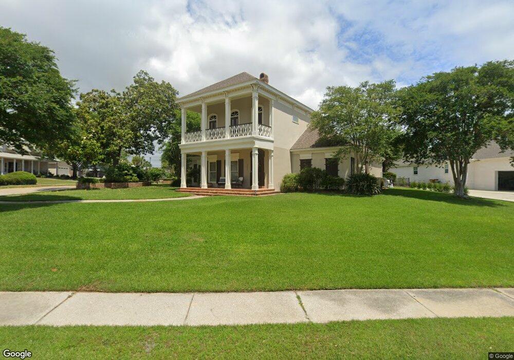
2018 Pointe Clear Blvd Biloxi, MS 39531
Estimated Value: $584,000 - $680,837
4
Beds
2
Baths
3,832
Sq Ft
$169/Sq Ft
Est. Value
About This Home
This home is located at 2018 Pointe Clear Blvd, Biloxi, MS 39531 and is currently estimated at $648,959, approximately $169 per square foot. 2018 Pointe Clear Blvd is a home located in Harrison County with nearby schools including Popps Ferry Elementary School, Biloxi Junior High School, and Biloxi High School.
Ownership History
Date
Name
Owned For
Owner Type
Purchase Details
Closed on
Dec 13, 2023
Sold by
Hollis Erin R
Bought by
Hollis Charles D
Current Estimated Value
Purchase Details
Closed on
Nov 25, 2020
Sold by
Lee James Wndell and Lee Floy Jeannette
Bought by
Hollis Erin R and Hollis Charles D
Home Financials for this Owner
Home Financials are based on the most recent Mortgage that was taken out on this home.
Original Mortgage
$466,058
Interest Rate
2.8%
Mortgage Type
New Conventional
Create a Home Valuation Report for This Property
The Home Valuation Report is an in-depth analysis detailing your home's value as well as a comparison with similar homes in the area
Home Values in the Area
Average Home Value in this Area
Purchase History
| Date | Buyer | Sale Price | Title Company |
|---|---|---|---|
| Hollis Charles D | -- | None Listed On Document | |
| Hollis Erin R | -- | None Available |
Source: Public Records
Mortgage History
| Date | Status | Borrower | Loan Amount |
|---|---|---|---|
| Previous Owner | Hollis Erin R | $466,058 |
Source: Public Records
Tax History
| Year | Tax Paid | Tax Assessment Tax Assessment Total Assessment is a certain percentage of the fair market value that is determined by local assessors to be the total taxable value of land and additions on the property. | Land | Improvement |
|---|---|---|---|---|
| 2025 | $4,939 | $46,870 | $0 | $0 |
| 2024 | $4,892 | $46,876 | $0 | $0 |
| 2023 | $4,813 | $46,575 | $0 | $0 |
| 2022 | $4,813 | $46,575 | $0 | $0 |
| 2021 | $4,802 | $46,477 | $0 | $0 |
| 2020 | $4,066 | $44,498 | $0 | $0 |
| 2019 | $4,066 | $44,498 | $0 | $0 |
| 2018 | $3,989 | $44,498 | $0 | $0 |
| 2017 | $3,989 | $43,801 | $0 | $0 |
| 2015 | $3,917 | $43,142 | $0 | $0 |
| 2014 | -- | $7,500 | $0 | $0 |
| 2013 | -- | $43,142 | $7,500 | $35,642 |
Source: Public Records
Map
Nearby Homes
- 2004 Claudette Ct
- 2004 Bayou Laporte Dr
- 2013 Pointe Clear Dr
- 2013 Rue Ulysse
- 2062 Mauvilla Cove
- 2105 Ward Ln
- 444 Venito Dr
- 0 Harmanson Vue
- 364 Hiller Dr
- 319 Belvedere Dr
- 416 Woodland Park Dr
- 2168 Alice Dr
- 325 Hiller Dr
- 479 Linda Dr
- 2129 Floyd Dr
- Lot 11 Wetzel Dr
- 615 N Haven Dr
- 409 Linda Dr
- 489 Jordan Dr
- Lot 12 Wetzel Dr
- 2018 Pointe Clear Dr
- 2006 Claudette Ct
- 0 Lot 34 Bayou Laporte Unit 4030630
- 0 Claudette Ct
- Lot 34 Bayou Laporte
- 2007 Bayou Laporte Dr
- 2019 Pointe Clear Blvd
- 2017 Pointe Clear Blvd
- 2017 Pointe Clear Dr
- 2020 Pointe Clear Blvd
- 2015 Pointe Clear Dr
- 2011 Bayou Laporte Dr
- 2013 Pointe Clear Blvd
- 2003 Claudette Ct
- 2015 Marisol Ct
- 2013 Bayou Laporte Dr
- 2002 Claudette Ct
- 2017 Marisol Ct
- 2006 Bayou Laporte Dr
- 2008 Bayou Laporte Dr
Your Personal Tour Guide
Ask me questions while you tour the home.