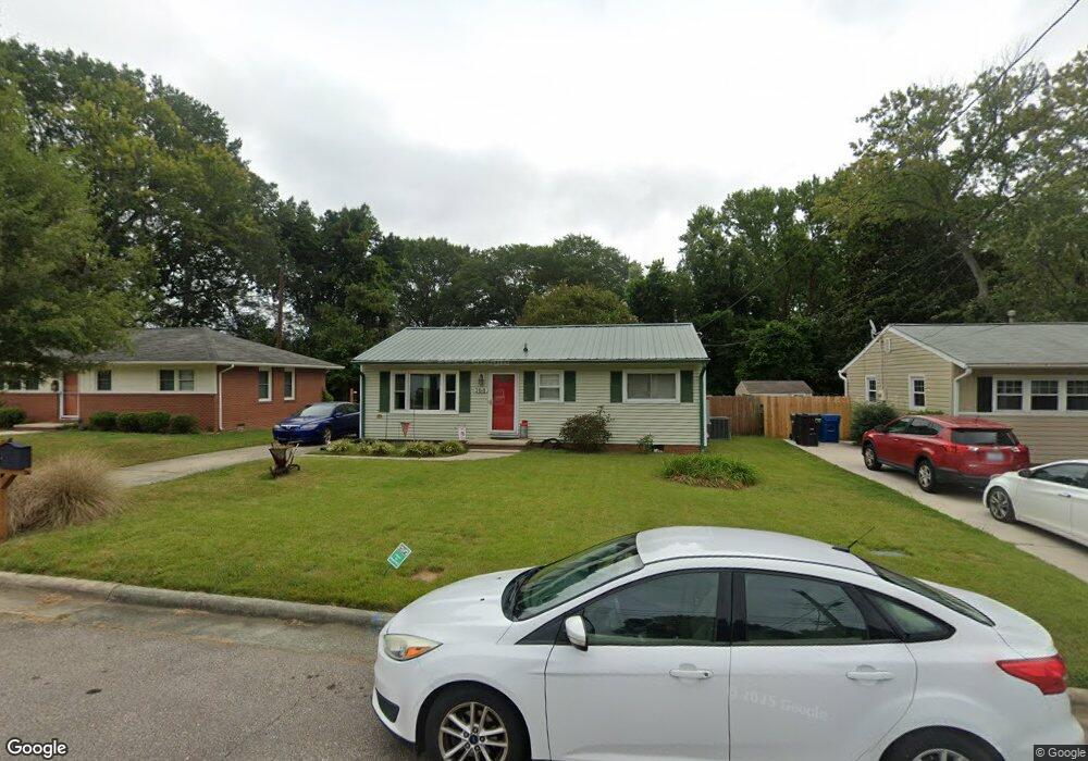
2018 Walnut St Durham, NC 27705
Watts Hospital-Hillandale NeighborhoodEstimated Value: $353,000 - $403,000
3
Beds
1
Bath
1,434
Sq Ft
$260/Sq Ft
Est. Value
About This Home
This home is located at 2018 Walnut St, Durham, NC 27705 and is currently estimated at $372,866, approximately $260 per square foot. 2018 Walnut St is a home located in Durham County with nearby schools including E K Powe Elementary, W.G. Pearson Elementary School, and Brogden Middle.
Ownership History
Date
Name
Owned For
Owner Type
Purchase Details
Closed on
Mar 30, 2018
Sold by
White Joyce S
Bought by
White Joyce S and White Chelsea S
Current Estimated Value
Purchase Details
Closed on
Aug 10, 1998
Sold by
Stone Angela Renee Harris and Robinson Diane Howell
Bought by
White Alexander C and White Joyce S
Home Financials for this Owner
Home Financials are based on the most recent Mortgage that was taken out on this home.
Original Mortgage
$54,000
Outstanding Balance
$11,305
Interest Rate
6.96%
Estimated Equity
$361,561
Create a Home Valuation Report for This Property
The Home Valuation Report is an in-depth analysis detailing your home's value as well as a comparison with similar homes in the area
Home Values in the Area
Average Home Value in this Area
Purchase History
| Date | Buyer | Sale Price | Title Company |
|---|---|---|---|
| White Joyce S | -- | None Available | |
| White Alexander C | $60,000 | -- |
Source: Public Records
Mortgage History
| Date | Status | Borrower | Loan Amount |
|---|---|---|---|
| Open | White Alexander C | $54,000 |
Source: Public Records
Tax History
| Year | Tax Paid | Tax Assessment Tax Assessment Total Assessment is a certain percentage of the fair market value that is determined by local assessors to be the total taxable value of land and additions on the property. | Land | Improvement |
|---|---|---|---|---|
| 2025 | $1,875 | $378,327 | $166,375 | $211,952 |
| 2024 | $2,005 | $287,424 | $51,255 | $236,169 |
| 2023 | $3,765 | $287,424 | $51,255 | $236,169 |
| 2022 | $3,679 | $287,424 | $51,255 | $236,169 |
| 2021 | $3,661 | $287,424 | $51,255 | $236,169 |
| 2020 | $3,575 | $287,424 | $51,255 | $236,169 |
| 2019 | $3,575 | $313,324 | $51,255 | $262,069 |
| 2018 | $3,509 | $258,694 | $48,240 | $210,454 |
| 2017 | $1,742 | $258,694 | $48,240 | $210,454 |
| 2016 | $1,683 | $258,694 | $48,240 | $210,454 |
| 2015 | $1,209 | $174,606 | $23,511 | $151,095 |
| 2014 | $973 | $140,571 | $23,511 | $117,060 |
Source: Public Records
Map
Nearby Homes
- 2207 Edwin Ave
- 2217 Stroller Ave
- 1612 Maryland Ave
- 2116 Pershing St
- 2020 Pershing St
- 2128 Strebor St
- 1820 Forest Rd
- 1811 Forest Rd
- 2305 Sprunt Ave
- 1505 Virginia Ave
- 2205 Tampa Ave
- 1801 Forest Rd
- 2518 Indian Trail
- 1708 Forest Rd
- 2709 Fawn Ave
- 2711 Fawn Ave
- 1423 Hudson Ave
- 2524 Indian Trail
- 2803 Fawn Ave
- 2805 Fawn Ave
- 2020 Walnut St
- 2022 Walnut St
- 2010 Walnut St
- 2006 Walnut St
- 2011 Carolina Ave
- 2005 Carolina Ave
- 2024 Walnut St
- 2004 Walnut St
- 2013 Carolina Ave
- 2023 Walnut St
- 2021 Walnut St
- 2025 Walnut St
- 2027 Walnut St
- 2019 Walnut St
- 2015 Carolina Ave
- 2026 Walnut St
- 2000 Walnut St
- 2029 Walnut St
- 2017 Walnut St
- 2017 Carolina Ave
Your Personal Tour Guide
Ask me questions while you tour the home.