R
Seller's Agent in 2018
Ryan Gehris
Unreal Estate Brokerage LLC

Estimated Value: $183,000 - $271,000
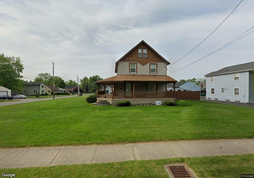
This beautiful turn key home has 3000 sqft of completely remodeled living space, Open concept with lots of indoor/outdoor entertaining space, Large family room, Separate living room with office nook, Eat in kitchen with 3 large pantries, Island plus peninsula, All stainless appliances included, Large laundry room off kitchen (washer/drier included) with plenty of extra storage, Large outdoor entertaining area with 14'x 28' in ground pool, BBQ space, Two gazebos large one for you smaller one for the grill, all surrounded by a 6' privacy fence, Large 10'x 75' covered wrap around porch, that's 750 sqft of additional entertaining/relaxing space, 2 separate basements; one finished that could be a fourth bedroom, second unfinished basement adds storage galore, Large 26'x 40' garage with second floor attic space that can used as a workshop, 16'x 10' overhead door, 11'8" ceilings, lots of upper and lower cabinets with counter top, Plenty of storage for tools and miscellaneous items.
Last Agent to Sell the Property
Ryan Gehris
Unreal Estate Brokerage LLC License #0556144 Listed on: 08/21/2018
Last Buyer's Agent
Nonmls
Houston Association of REALTORS
| Date | Buyer | Sale Price | Title Company |
|---|---|---|---|
| Kinnamon Jeffrey P | -- | None Listed On Document | |
| Kinnamon Jeffrey P | $172,000 | None Available | |
| Charla R Dickson | -- | -- |
| Date | Status | Borrower | Loan Amount |
|---|---|---|---|
| Previous Owner | Kinnamon Jeffrey P | $166,840 |
| Date | Event | Price | List to Sale | Price per Sq Ft |
|---|---|---|---|---|
| 12/30/2021 12/30/21 | Off Market | $172,000 | -- | -- |
| 10/30/2018 10/30/18 | Sold | $172,000 | -1.7% | $57 / Sq Ft |
| 09/30/2018 09/30/18 | Pending | -- | -- | -- |
| 08/21/2018 08/21/18 | For Sale | $175,000 | -- | $58 / Sq Ft |
| Year | Tax Paid | Tax Assessment Tax Assessment Total Assessment is a certain percentage of the fair market value that is determined by local assessors to be the total taxable value of land and additions on the property. | Land | Improvement |
|---|---|---|---|---|
| 2024 | $2,715 | $64,440 | $5,430 | $59,010 |
| 2023 | $2,690 | $64,440 | $5,430 | $59,010 |
| 2022 | $2,259 | $46,240 | $5,430 | $40,810 |
| 2021 | $2,372 | $46,240 | $5,430 | $40,810 |
| 2020 | $2,394 | $46,240 | $5,430 | $40,810 |
| 2019 | $2,313 | $42,530 | $5,430 | $37,100 |
| 2018 | $1,832 | $42,530 | $5,430 | $37,100 |
| 2017 | $1,853 | $42,530 | $5,430 | $37,100 |
| 2016 | $1,968 | $44,280 | $5,430 | $38,850 |
| 2015 | $1,947 | $44,280 | $5,430 | $38,850 |
| 2014 | $2,460 | $44,280 | $5,430 | $38,850 |
| 2013 | $2,461 | $46,770 | $5,430 | $41,340 |
R
Seller's Agent in 2018
Ryan Gehris
Unreal Estate Brokerage LLC
N
Buyer's Agent in 2018
Nonmls
Houston Association of REALTORS
Source: Houston Association of REALTORS®
MLS Number: 36008796
APN: 25-327350
Disclaimer: Certain information contained herein is derived from information provided by parties other than Homes.com. All information provided is deemed reliable, but is not guaranteed to be accurate and should be independently verified.
![]() Copyright 2026, Houston REALTORS® Information Service, Inc.
Copyright 2026, Houston REALTORS® Information Service, Inc.
The information provided is exclusively for consumers’ personal, non-commercial use, and may not be used for any purpose other than to identify prospective properties consumers may be interested in purchasing.
Information is deemed reliable but not guaranteed.
Ask me questions while you tour the home.
