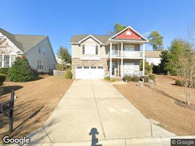
202 Ashburton Ln West Columbia, SC 29170
Edmund NeighborhoodEstimated Value: $222,000 - $307,000
4
Beds
3
Baths
2,404
Sq Ft
$118/Sq Ft
Est. Value
About This Home
This home is located at 202 Ashburton Ln, West Columbia, SC 29170 and is currently estimated at $284,217, approximately $118 per square foot. 202 Ashburton Ln is a home located in Lexington County with nearby schools including Saxe Gotha Elementary School, White Knoll Middle School, and White Knoll High School.
Ownership History
Date
Name
Owned For
Owner Type
Purchase Details
Closed on
Mar 27, 2015
Sold by
Romero Jose L and Zapata Katty
Bought by
Zapta Katty
Current Estimated Value
Purchase Details
Closed on
Mar 20, 2013
Sold by
Romero Jose L
Bought by
Romero Jsoe L and Zapata Katty Romero
Purchase Details
Closed on
Sep 12, 2012
Sold by
Pope Brantley
Bought by
Romero Jose L
Purchase Details
Closed on
Jul 2, 2009
Sold by
Hurricane Construction Inc
Bought by
Pope Brantley
Purchase Details
Closed on
Jun 9, 2008
Sold by
Lake Frances Development Inc
Bought by
Hurricane Construction Inc
Create a Home Valuation Report for This Property
The Home Valuation Report is an in-depth analysis detailing your home's value as well as a comparison with similar homes in the area
Home Values in the Area
Average Home Value in this Area
Purchase History
| Date | Buyer | Sale Price | Title Company |
|---|---|---|---|
| Zapta Katty | -- | -- | |
| Romero Jsoe L | -- | -- | |
| Romero Jose L | $90,000 | -- | |
| Pope Brantley | $136,000 | -- | |
| Hurricane Construction Inc | $150,000 | -- |
Source: Public Records
Mortgage History
| Date | Status | Borrower | Loan Amount |
|---|---|---|---|
| Open | Zapata Katty | $100,000 | |
| Previous Owner | Romero Jose L | $3,915,000 |
Source: Public Records
Tax History Compared to Growth
Tax History
| Year | Tax Paid | Tax Assessment Tax Assessment Total Assessment is a certain percentage of the fair market value that is determined by local assessors to be the total taxable value of land and additions on the property. | Land | Improvement |
|---|---|---|---|---|
| 2024 | $1,136 | $7,614 | $1,440 | $6,174 |
| 2023 | $1,136 | $7,614 | $1,440 | $6,174 |
| 2022 | $1,117 | $7,614 | $1,440 | $6,174 |
| 2020 | $1,162 | $7,614 | $1,440 | $6,174 |
| 2019 | $1,163 | $7,483 | $1,440 | $6,043 |
| 2018 | $1,141 | $7,483 | $1,440 | $6,043 |
| 2017 | $1,107 | $7,483 | $1,440 | $6,043 |
| 2016 | $1,097 | $7,482 | $1,440 | $6,042 |
| 2014 | $1,089 | $7,758 | $1,400 | $6,358 |
| 2013 | -- | $11,640 | $2,100 | $9,540 |
Source: Public Records
Map
Nearby Homes
- 427 Laurel Mist Ln
- 113 Laurel Hill Dr
- 123 Turnfield Dr
- 271 Lake Frances Dr
- 465 Henslowe Ln
- 241 Highgrove Cir
- 130 Dogwood Cir
- 117 Pinehurst Ct
- 420 Congaree Ridge Ct
- 1425 Hammerwood Ln
- 1412 Hammerwood Ln
- 272 Winchester Ct
- 104 Candlelight Dr
- 4383 Platt Springs Rd
- 249 Loop Rd
- 221 Isom Ln
- 3122 Mctavish Ave
- 4974 Platt Springs Rd
- 169 Norman Dr
- 1339 Laurel St
- 202 Ashburton Ln
- 206 Ashburton Ln
- 103 Adler Rd
- 407 Laurel Mist Ln
- 210 Ashburton Ln
- 411 Laurel Mist Ln
- 107 Adler Rd
- 415 Laurel Mist Ln
- 203 Ashburton Ln
- 111 Adler Rd
- 214 Ashburton Ln
- 207 Ashburton Ln
- 419 Laurel Mist Ln
- 211 Ashburton Ln
- 218 Ashburton Ln
- 423 Laurel Mist Ln
- 215 Ashburton Ln
- 102 Adler Rd
- 502 Laurel Mist Ct
- 106 Adler Rd