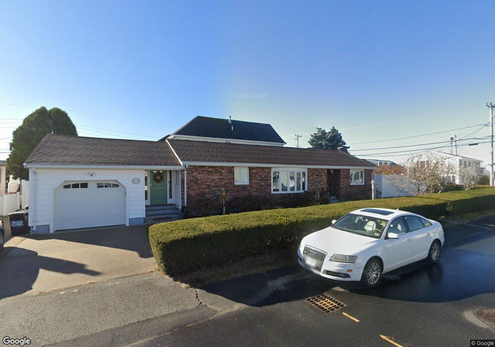
202 Bristol St Seabrook, NH 03874
Seabrook Beach NeighborhoodEstimated Value: $1,014,000 - $1,348,000
2
Beds
2
Baths
1,208
Sq Ft
$925/Sq Ft
Est. Value
About This Home
This home is located at 202 Bristol St, Seabrook, NH 03874 and is currently estimated at $1,117,554, approximately $925 per square foot. 202 Bristol St is a home located in Rockingham County with nearby schools including Seabrook Elementary School, Seabrook Middle School, and Winnacunnet High School.
Ownership History
Date
Name
Owned For
Owner Type
Purchase Details
Closed on
Feb 19, 2002
Sold by
Cms Rt
Bought by
Ferrick Michael F and Ferrick Cynthia A
Current Estimated Value
Home Financials for this Owner
Home Financials are based on the most recent Mortgage that was taken out on this home.
Original Mortgage
$283,000
Interest Rate
7.14%
Mortgage Type
Purchase Money Mortgage
Create a Home Valuation Report for This Property
The Home Valuation Report is an in-depth analysis detailing your home's value as well as a comparison with similar homes in the area
Home Values in the Area
Average Home Value in this Area
Purchase History
| Date | Buyer | Sale Price | Title Company |
|---|---|---|---|
| Ferrick Michael F | $333,000 | -- |
Source: Public Records
Mortgage History
| Date | Status | Borrower | Loan Amount |
|---|---|---|---|
| Open | Ferrick Michael F | $268,000 | |
| Closed | Ferrick Michael F | $283,000 |
Source: Public Records
Tax History Compared to Growth
Tax History
| Year | Tax Paid | Tax Assessment Tax Assessment Total Assessment is a certain percentage of the fair market value that is determined by local assessors to be the total taxable value of land and additions on the property. | Land | Improvement |
|---|---|---|---|---|
| 2024 | $9,909 | $845,500 | $607,000 | $238,500 |
| 2023 | $9,953 | $659,600 | $462,600 | $197,000 |
| 2022 | $8,740 | $659,600 | $462,600 | $197,000 |
| 2021 | $9,056 | $659,600 | $462,600 | $197,000 |
| 2020 | $8,256 | $517,000 | $370,200 | $146,800 |
| 2019 | $8,143 | $517,000 | $370,200 | $146,800 |
| 2018 | $8,401 | $517,000 | $370,200 | $146,800 |
| 2017 | $7,855 | $483,400 | $336,600 | $146,800 |
| 2016 | $7,411 | $501,100 | $354,300 | $146,800 |
| 2015 | $6,025 | $407,400 | $281,500 | $125,900 |
| 2014 | $6,032 | $395,000 | $269,100 | $125,900 |
| 2013 | $6,423 | $420,600 | $294,700 | $125,900 |
Source: Public Records
Map
Nearby Homes
- 376 Ocean Blvd
- 18 River St
- 9 Tyngsboro St
- 27 Cross Beach Rd
- 13-15 Ocean Blvd
- 13 Ocean Blvd
- 15 Ocean Blvd
- 3 Harris Ave
- 5 Fellows Ave
- 10 Haverhill Ave Unit 1
- 10 Haverhill Ave Unit 2
- 19 Riverview Terrace
- 17 Johnson Ave
- 7 Perkins Ave
- 3 Perkins Ave Unit 2
- 3 Perkins Ave Unit 1
- 27 Perkins Ave
- 22 Perkins Ave
- 128 Ashworth Ave Unit 303
- 22 1/2 I St Unit 2
- 201 Portsmouth Ave
- 203 Bristol St
- 240 Bristol St
- 200 Portsmouth Ave
- 239 Bristol St
- 204 Bristol St
- 238 Bristol St
- 288 Portsmouth Ave
- 241 Portsmouth Ave
- 199 Tilton St
- 289 Portsmouth Ave
- 289 Portsmouth Ave Unit UP
- 289 Portsmouth Ave Unit Down
- 289 Portsmouth Ave Unit Downstairs
- 289 Portsmouth Ave Unit Upstairs
- 289 Portsmouth Ave Unit Downstairs Unit
- 287 Portsmouth Ave
- 198 Tilton St
- 237 Bristol St
- 290 Portsmouth Ave