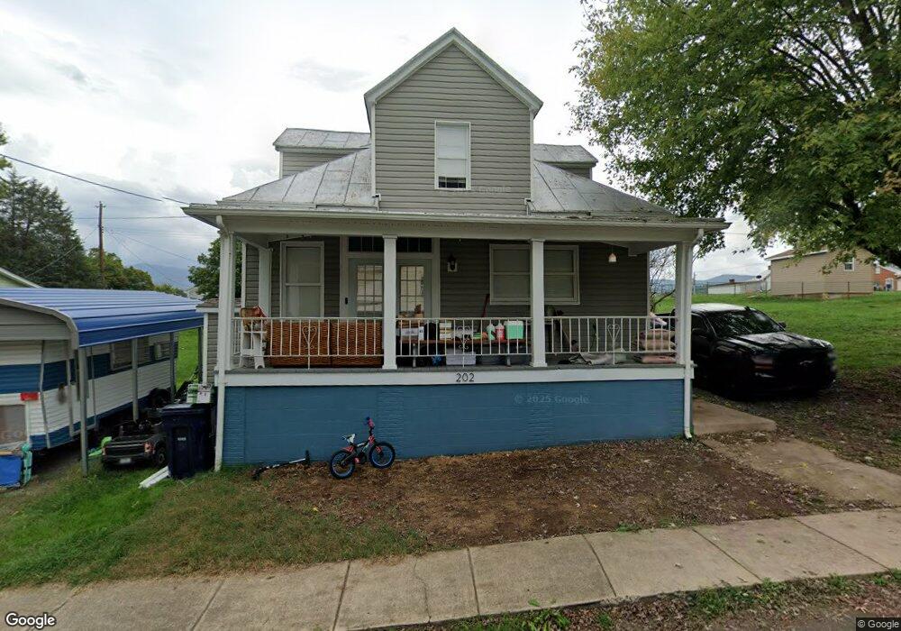
202 Deford Ave Stanley, VA 22851
Estimated Value: $262,452 - $282,000
3
Beds
2
Baths
1,523
Sq Ft
$179/Sq Ft
Est. Value
About This Home
This home is located at 202 Deford Ave, Stanley, VA 22851 and is currently estimated at $272,226, approximately $178 per square foot. 202 Deford Ave is a home located in Page County with nearby schools including Stanley Seventh-day Adventist School and Mt. Carmel Christian Academy.
Ownership History
Date
Name
Owned For
Owner Type
Purchase Details
Closed on
Aug 15, 2022
Sold by
Davis Carol A
Bought by
Lane Joshua
Current Estimated Value
Home Financials for this Owner
Home Financials are based on the most recent Mortgage that was taken out on this home.
Original Mortgage
$204,250
Outstanding Balance
$194,814
Interest Rate
5.22%
Mortgage Type
Construction
Estimated Equity
$77,412
Purchase Details
Closed on
Nov 28, 2016
Sold by
Nichols David B and Nichols Jane A
Bought by
Davis Carol A
Home Financials for this Owner
Home Financials are based on the most recent Mortgage that was taken out on this home.
Original Mortgage
$123,000
Interest Rate
3.52%
Mortgage Type
VA
Purchase Details
Closed on
Dec 15, 2014
Purchase Details
Closed on
Dec 30, 2005
Create a Home Valuation Report for This Property
The Home Valuation Report is an in-depth analysis detailing your home's value as well as a comparison with similar homes in the area
Home Values in the Area
Average Home Value in this Area
Purchase History
| Date | Buyer | Sale Price | Title Company |
|---|---|---|---|
| Lane Joshua | $220,000 | -- | |
| Davis Carol A | $138,000 | -- | |
| -- | $95,200 | -- | |
| -- | $134,000 | -- |
Source: Public Records
Mortgage History
| Date | Status | Borrower | Loan Amount |
|---|---|---|---|
| Open | Lane Joshua | $204,250 | |
| Previous Owner | Davis Carol A | $123,000 |
Source: Public Records
Tax History Compared to Growth
Tax History
| Year | Tax Paid | Tax Assessment Tax Assessment Total Assessment is a certain percentage of the fair market value that is determined by local assessors to be the total taxable value of land and additions on the property. | Land | Improvement |
|---|---|---|---|---|
| 2025 | $956 | $131,000 | $20,000 | $111,000 |
| 2024 | $956 | $131,000 | $20,000 | $111,000 |
| 2023 | $956 | $131,000 | $20,000 | $111,000 |
| 2022 | $956 | $131,000 | $20,000 | $111,000 |
| 2021 | $520 | $131,000 | $20,000 | $111,000 |
| 2020 | $520 | $71,200 | $20,000 | $51,200 |
| 2019 | $520 | $71,200 | $20,000 | $51,200 |
| 2018 | $399 | $71,200 | $20,000 | $51,200 |
| 2017 | $470 | $71,200 | $20,000 | $51,200 |
| 2016 | $452 | $68,500 | $20,000 | $48,500 |
| 2015 | $630 | $98,500 | $20,000 | $78,500 |
| 2014 | $630 | $98,500 | $20,000 | $78,500 |
Source: Public Records
Map
Nearby Homes
- 206 Masonic Dr
- TBD Bosley Dr
- TBD Judy Ln
- 115 Sunset Dr
- 0 Judy Ln Unit 650150
- 214 Chapel Rd
- 551 Park Rd
- 218 Honeyville Rd
- 343 Park Rd
- 841 Judy Lane Extension
- 1529 Goodrich Rd
- 1294 E Main St
- 481 Eldon Yates Dr
- 467 Vista View Rd
- 650 Honeyville Rd
- 586 Eldon Yates Dr
- 5672 Mill Creek Rd
- 127 Deerfield Estates Dr
- 490 Leola Loop
- 389 Leola Loop