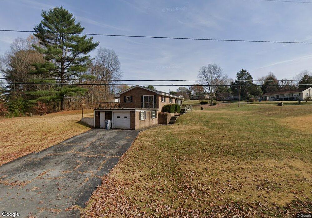
202 Forrest Dr Jonesborough, TN 37659
Estimated Value: $213,000 - $259,000
3
Beds
1
Bath
1,550
Sq Ft
$153/Sq Ft
Est. Value
About This Home
This home is located at 202 Forrest Dr, Jonesborough, TN 37659 and is currently estimated at $237,096, approximately $152 per square foot. 202 Forrest Dr is a home located in Washington County with nearby schools including Jonesborough Elementary School, Jonesborough Middle School, and David Crockett High School.
Ownership History
Date
Name
Owned For
Owner Type
Purchase Details
Closed on
Feb 27, 2003
Sold by
Hensley Charles A
Bought by
Baker Leon
Current Estimated Value
Purchase Details
Closed on
Nov 7, 1997
Sold by
Baines Melvin D and Baines Linda
Bought by
Hensley Charles
Home Financials for this Owner
Home Financials are based on the most recent Mortgage that was taken out on this home.
Original Mortgage
$58,600
Interest Rate
7.27%
Purchase Details
Closed on
Nov 5, 1997
Bought by
Hensley Charles A and Hensley Joyce A
Home Financials for this Owner
Home Financials are based on the most recent Mortgage that was taken out on this home.
Original Mortgage
$58,600
Interest Rate
7.27%
Create a Home Valuation Report for This Property
The Home Valuation Report is an in-depth analysis detailing your home's value as well as a comparison with similar homes in the area
Home Values in the Area
Average Home Value in this Area
Purchase History
| Date | Buyer | Sale Price | Title Company |
|---|---|---|---|
| Baker Leon | $76,000 | -- | |
| Hensley Charles | $73,250 | -- | |
| Hensley Charles A | $73,300 | -- |
Source: Public Records
Mortgage History
| Date | Status | Borrower | Loan Amount |
|---|---|---|---|
| Previous Owner | Hensley Charles A | $58,600 |
Source: Public Records
Tax History
| Year | Tax Paid | Tax Assessment Tax Assessment Total Assessment is a certain percentage of the fair market value that is determined by local assessors to be the total taxable value of land and additions on the property. | Land | Improvement |
|---|---|---|---|---|
| 2025 | $919 | $53,725 | $9,925 | $43,800 |
| 2024 | $919 | $53,725 | $9,925 | $43,800 |
| 2023 | $756 | $35,150 | $0 | $0 |
| 2022 | $756 | $35,150 | $9,925 | $25,225 |
| 2021 | $1,178 | $35,150 | $9,925 | $25,225 |
| 2020 | $1,178 | $35,150 | $9,925 | $25,225 |
| 2019 | $778 | $35,150 | $9,925 | $25,225 |
| 2018 | $1,095 | $29,675 | $8,275 | $21,400 |
| 2017 | $1,095 | $29,675 | $8,275 | $21,400 |
| 2016 | $1,095 | $29,675 | $8,275 | $21,400 |
| 2015 | $976 | $29,675 | $8,275 | $21,400 |
| 2014 | $976 | $29,675 | $8,275 | $21,400 |
Source: Public Records
Map
Nearby Homes
- Tbd E Jackson Blvd
- 211 Forest Cir
- 000 E Jackson Blvd
- 121 Vines Dr
- Tbd Jackson Blvd
- Tbd Forest Dr
- 617 E Main St
- 631 E Main St
- 118 N Lincoln Ave
- Tbd Old Boones Creek Rd
- 298 Ruby Rose Ridge
- 310 Ruby Rose Ridge
- 252 Ruby Rose Ridge
- 369 Wilson Knob View
- 188 Vines Dr
- 246 Ruby Rose Ridge
- 391 Wilson Knob View
- 249 Ruby Rose Ridge
- 234 Ruby Rose Ridge
- TRACT 3B Headtown Rd
- 1005 Shamrock Dr
- 207 Forest Dr
- 207 Forrest Dr
- 1004 Shamrock Dr
- 1002 Shamrock Dr
- 203 Forest Dr
- 1007 Shamrock Dr
- 1006 Shamrock Dr
- 201 Forrest Cir
- 301 Forest Cir
- 1008 Shamrock Dr
- 1009 Shamrock Dr
- 103 Forrest Dr
- 203 Forrest Cir
- 503 E Main St
- 501 E Main St
- 198 Forrest Cir
- 1010 Shamrock Dr
- 505 E Main St
- 198 Forest Cir
Your Personal Tour Guide
Ask me questions while you tour the home.