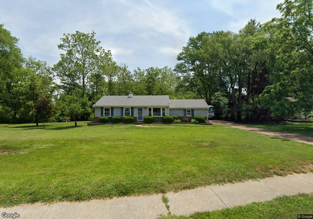
202 Ramsey Ln Ballwin, MO 63021
Estimated Value: $293,000 - $303,611
3
Beds
2
Baths
1,153
Sq Ft
$258/Sq Ft
Est. Value
About This Home
This home is located at 202 Ramsey Ln, Ballwin, MO 63021 and is currently estimated at $297,403, approximately $257 per square foot. 202 Ramsey Ln is a home located in St. Louis County with nearby schools including Ballwin Elementary School, Selvidge Middle School, and Marquette Sr. High School.
Ownership History
Date
Name
Owned For
Owner Type
Purchase Details
Closed on
Sep 30, 2003
Sold by
Buckley Elizabeth J and Buckley Ronald D
Bought by
Buckley Ronald D and Buckley Elizabeth J
Current Estimated Value
Home Financials for this Owner
Home Financials are based on the most recent Mortgage that was taken out on this home.
Original Mortgage
$132,000
Interest Rate
5.63%
Mortgage Type
Purchase Money Mortgage
Purchase Details
Closed on
Mar 26, 1999
Sold by
Obrien Daniel L and Obrien Elizabeth J
Bought by
Baxter Elizabeth J
Home Financials for this Owner
Home Financials are based on the most recent Mortgage that was taken out on this home.
Original Mortgage
$80,000
Interest Rate
6.41%
Create a Home Valuation Report for This Property
The Home Valuation Report is an in-depth analysis detailing your home's value as well as a comparison with similar homes in the area
Home Values in the Area
Average Home Value in this Area
Purchase History
| Date | Buyer | Sale Price | Title Company |
|---|---|---|---|
| Buckley Ronald D | -- | -- | |
| Baxter Elizabeth J | -- | Title Insurers Agency |
Source: Public Records
Mortgage History
| Date | Status | Borrower | Loan Amount |
|---|---|---|---|
| Closed | Buckley Ronald D | $132,000 | |
| Closed | Baxter Elizabeth J | $80,000 |
Source: Public Records
Tax History
| Year | Tax Paid | Tax Assessment Tax Assessment Total Assessment is a certain percentage of the fair market value that is determined by local assessors to be the total taxable value of land and additions on the property. | Land | Improvement |
|---|---|---|---|---|
| 2025 | $3,620 | $57,160 | $29,530 | $27,630 |
| 2024 | $3,620 | $51,650 | $24,610 | $27,040 |
| 2023 | $3,617 | $51,650 | $24,610 | $27,040 |
| 2022 | $3,025 | $40,060 | $24,610 | $15,450 |
| 2021 | $3,003 | $40,060 | $24,610 | $15,450 |
| 2020 | $2,718 | $34,540 | $18,770 | $15,770 |
| 2019 | $2,729 | $34,540 | $18,770 | $15,770 |
| 2018 | $2,560 | $30,530 | $15,160 | $15,370 |
| 2017 | $2,499 | $30,530 | $15,160 | $15,370 |
| 2016 | $2,211 | $25,940 | $10,550 | $15,390 |
Source: Public Records
Map
Nearby Homes
- 112 Shirley Ln
- 101 Half Moon Bay Ln
- 614 Barton Ln
- 120 Birchwood Dr
- 229 Victor Ct
- 275 Essen Ct Unit TBB
- 277 Ramsey Ln
- 107 Falmouth Dr
- 547 Blazedwood Dr
- 365 Remington Way Dr
- 260 Monroe Mill Dr
- 557 Happy Ct
- 105 Timka Dr
- 533 Golfwood Dr
- 815 Wendevy Ct Unit 16B
- 832 Wendevy Ct Unit 8B
- 140 Burtonwood Dr
- 837 Wendevy Ct Unit 11A
- 842 Wendevy Ct
- 128 Shadalane Walk Unit A
- 204 Ramsey Ln
- 116 Sunnyside Ct
- 206 Ramsey Ln
- 120 Sunnyside Ct
- 208 Ramsey Ln
- 122 Sunnyside Ct
- 114 Sunnyside Ct
- 115 Sunnyside Ct
- 117 Sunnyside Ct
- 210 Ramsey Ln
- 207 Ramsey Ln
- 212 Ramsey Ln
- 119 Sunnyside Ct
- 112 Sunnyside Ct
- 209 Ramsey Ln
- 109 Sunnyside Ct
- 211 Ramsey Ln
- 214 Ramsey Ln
- 203 Ramsey Ln Unit none
- 110 Sunnyside Ct Unit A
Your Personal Tour Guide
Ask me questions while you tour the home.