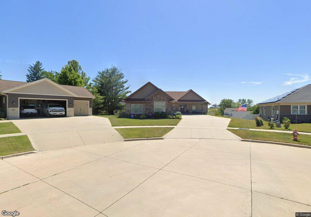
202 Ridge View Dr West Branch, IA 52358
Estimated Value: $403,000 - $655,000
4
Beds
2
Baths
2,085
Sq Ft
$264/Sq Ft
Est. Value
About This Home
This home is located at 202 Ridge View Dr, West Branch, IA 52358 and is currently estimated at $551,211, approximately $264 per square foot. 202 Ridge View Dr is a home with nearby schools including Hoover Elementary School, West Branch Middle School, and West Branch High School.
Ownership History
Date
Name
Owned For
Owner Type
Purchase Details
Closed on
Nov 15, 2023
Sold by
Dr Horton Iowa Llc
Bought by
Sharp Lucas J and Schwickerath Miranda
Current Estimated Value
Purchase Details
Closed on
Sep 13, 2023
Sold by
Meadows Development Inc
Bought by
Larson Builders Inc
Home Financials for this Owner
Home Financials are based on the most recent Mortgage that was taken out on this home.
Original Mortgage
$491,261
Interest Rate
6.9%
Mortgage Type
Construction
Purchase Details
Closed on
Apr 1, 2022
Sold by
Meadows Development Inc
Bought by
D Hortoniowa Llc
Purchase Details
Closed on
Jan 4, 2022
Sold by
Kofoed Audrey R
Bought by
Moon Mitchell Charles
Purchase Details
Closed on
Jun 11, 2012
Sold by
Meadows Development Inc
Bought by
Kofoed Chris J and Kofoed Lisa W
Create a Home Valuation Report for This Property
The Home Valuation Report is an in-depth analysis detailing your home's value as well as a comparison with similar homes in the area
Home Values in the Area
Average Home Value in this Area
Purchase History
| Date | Buyer | Sale Price | Title Company |
|---|---|---|---|
| Sharp Lucas J | $305,000 | None Listed On Document | |
| Sharp Lucas J | $305,000 | None Listed On Document | |
| Larson Builders Inc | $76,000 | None Listed On Document | |
| Larson Builders Inc | $76,000 | None Listed On Document | |
| D Hortoniowa Llc | $369,000 | None Listed On Document | |
| Meadows Development Inc | $44,690 | Kennedy Michael W | |
| Moon Mitchell Charles | $200,000 | None Listed On Document | |
| Kofoed Chris J | $48,000 | None Available |
Source: Public Records
Mortgage History
| Date | Status | Borrower | Loan Amount |
|---|---|---|---|
| Previous Owner | Larson Builders Inc | $491,261 |
Source: Public Records
Tax History Compared to Growth
Tax History
| Year | Tax Paid | Tax Assessment Tax Assessment Total Assessment is a certain percentage of the fair market value that is determined by local assessors to be the total taxable value of land and additions on the property. | Land | Improvement |
|---|---|---|---|---|
| 2025 | $9,596 | $610,330 | $83,330 | $527,000 |
| 2024 | $9,596 | $588,700 | $83,330 | $505,370 |
| 2023 | $9,458 | $580,860 | $83,330 | $497,530 |
| 2022 | $8,634 | $455,440 | $60,180 | $395,260 |
| 2021 | $8,854 | $455,440 | $60,180 | $395,260 |
| 2020 | $8,576 | $446,180 | $50,920 | $395,260 |
| 2019 | $7,558 | $422,910 | $50,920 | $395,260 |
| 2018 | $7,386 | $422,350 | $0 | $0 |
| 2017 | $7,386 | $390,710 | $0 | $0 |
| 2016 | $7,242 | $390,710 | $0 | $0 |
| 2015 | $7,208 | $387,370 | $0 | $0 |
| 2014 | $7,208 | $710 | $0 | $0 |
Source: Public Records
Map
Nearby Homes
- 212 Dawson Dr
- 719 Sullivan St
- 173 Hilltop Dr
- Lot 17 Meadows Subdivision Part 5
- 611 Riley Ln
- 817 Prairie View Dr
- Lot 19 Meadows Subdivision Part 6
- 609 W Orange St
- Lot 17 Meadows Subdivision Part 6
- Lot 16 Meadows Subdivision Part 6
- Lot 18 Meadows Subdivision Part 6
- Lot 15 Meadows Subdivision Part 6
- Lot 14 Meadows Subdivision Part 6
- Lot 6 Meadows Subdivision Part 6
- Lot 11 Meadows Subdivision Part 6
- Lot 12 Meadows Subdivision Part 6
- Lot 13 Meadows Subdivision Part 6
- Lot 3 Meadows Subdivision Part 6
- Lots 1 & 2
- Lot 8 Meadows Subdivision Part 6
- 200 Ridge View Dr
- Lot 1 the Meadows Subdivision Part 4b Unit 1009 & 1011 Prairie
- Lot 1 the Meadows Subdivision Part 4b
- Lot 46 the Meadows Subdivision Part 4b
- Lot 24 the Meadows Subdivision Part 4b Unit 420 & 422 Dawson Dri
- Lot 24 the Meadows Subdivision Part 4b
- Lot 55 the Meadows Subdivision Part 4b
- Lot 23 the Meadows Subdivision Part 4b Unit 416 & 418 Dawson Dri
- Lot 23 the Meadows Subdivision Part 4b
- Lot 56 the Meadows Subdivision Part 4b
- Lot 49 the Meadows Subdivision Part 4b
- Lot 48 the Meadows Subdivision Part 4b
- 201 Ridge View Dr
- Lot 26 the Meadows Subdivision Part 4b Unit 428 & 430 Dawson Dri
- Lot 26 the Meadows Subdivision Part 4b
- Lot 53 the Meadows Subdivision Part 4b
- 204 Ridge View Dr
- Lot 7 the Meadows Subdivision Part 4b Unit 917 & 919 Prairie Vi
- Lot 22 the Meadows Subdivision Part 4b
- Lot 7 the Meadows Subdivision Part 4b