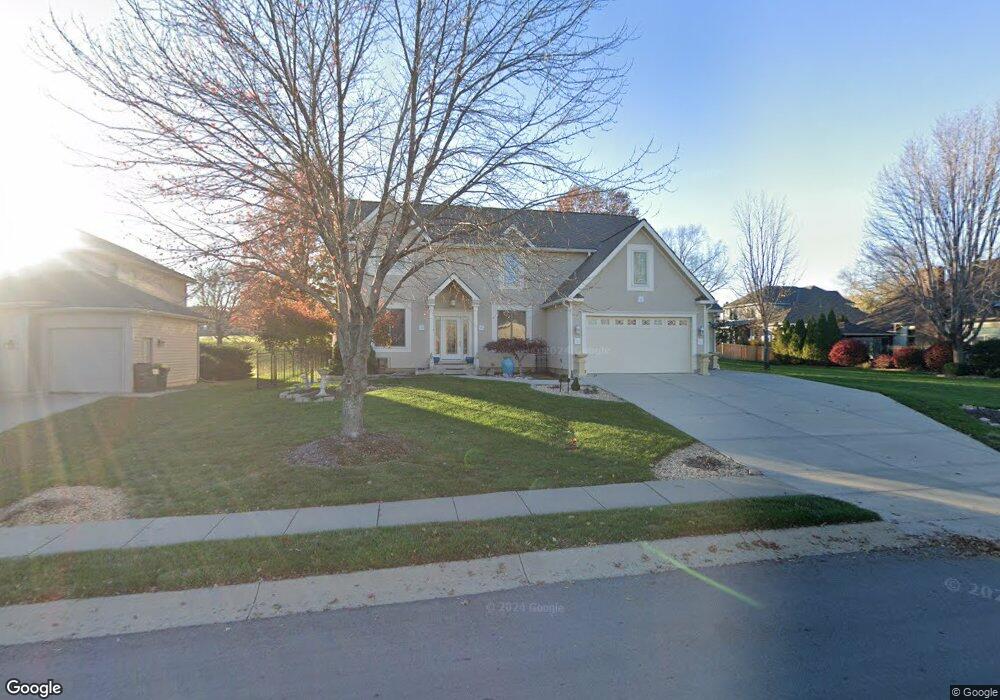
202 Southfork Rd Lansing, KS 66043
Estimated Value: $431,231 - $447,000
4
Beds
5
Baths
2,934
Sq Ft
$150/Sq Ft
Est. Value
About This Home
This home is located at 202 Southfork Rd, Lansing, KS 66043 and is currently estimated at $439,308, approximately $149 per square foot. 202 Southfork Rd is a home located in Leavenworth County with nearby schools including Lansing Elementary School, Lansing Middle 6-8, and Lansing High 9-12.
Ownership History
Date
Name
Owned For
Owner Type
Purchase Details
Closed on
Dec 1, 1999
Bought by
Hartel Robert J and Hartel Roojeanne
Current Estimated Value
Home Financials for this Owner
Home Financials are based on the most recent Mortgage that was taken out on this home.
Original Mortgage
$200,000
Interest Rate
7.75%
Mortgage Type
New Conventional
Create a Home Valuation Report for This Property
The Home Valuation Report is an in-depth analysis detailing your home's value as well as a comparison with similar homes in the area
Home Values in the Area
Average Home Value in this Area
Purchase History
| Date | Buyer | Sale Price | Title Company |
|---|---|---|---|
| Hartel Robert J | -- | -- |
Source: Public Records
Mortgage History
| Date | Status | Borrower | Loan Amount |
|---|---|---|---|
| Closed | Hartel Robert J | $200,000 | |
| Closed | Hartel Robert J | $29,830 |
Source: Public Records
Tax History Compared to Growth
Tax History
| Year | Tax Paid | Tax Assessment Tax Assessment Total Assessment is a certain percentage of the fair market value that is determined by local assessors to be the total taxable value of land and additions on the property. | Land | Improvement |
|---|---|---|---|---|
| 2025 | $6,089 | $46,794 | $6,968 | $39,826 |
| 2024 | $5,638 | $44,994 | $6,968 | $38,026 |
| 2023 | $5,638 | $43,263 | $6,968 | $36,295 |
| 2022 | $5,421 | $39,330 | $5,237 | $34,093 |
| 2021 | $5,374 | $37,248 | $5,237 | $32,011 |
| 2020 | $5,004 | $34,143 | $5,237 | $28,906 |
| 2019 | $4,829 | $32,913 | $5,237 | $27,676 |
| 2018 | $4,712 | $32,142 | $5,237 | $26,905 |
| 2017 | $4,656 | $31,694 | $5,237 | $26,457 |
| 2016 | $4,659 | $31,694 | $5,237 | $26,457 |
| 2015 | $4,645 | $31,694 | $5,237 | $26,457 |
| 2014 | $4,550 | $31,694 | $5,237 | $26,457 |
Source: Public Records
Map
Nearby Homes
- 875 Clearview Dr
- 866 Clearview Dr
- 833 Rock Creek Dr
- 1322 Rock Creek Ct
- 1221 S Desoto Rd
- 922 Southfork St
- 24431 139th St
- 811 4-H Rd
- 13965 Mc Intyre Rd
- 13788 McIntyre1 Rd
- 13788 Mcintyre Rd
- 13788 McIntyre2 Rd
- 000 4-H Rd
- 527 S Valley Dr
- 401 W Olive St
- 104 Olive St
- 522 Forestglen Ln
- 546 Hithergreen Dr
- 202 S Main St
- 124 S Main St
- 204 Southfork Rd
- 201 Canyon View Dr
- 206 Southfork Rd
- 203 Canyon View Dr
- 205 Southfork Rd
- 203 Southfork Rd
- 207 Southfork Rd
- 205 Canyon View Dr
- 208 Southfork Rd
- 209 Southfork Rd
- 1409 Rock Creek Dr
- 1405 Rock Creek Dr
- 200 Canyon View Dr
- 202 Canyon View Dr
- 197 Canyon View Dr
- 1413 Rock Creek Dr
- 1401 Rock Creek Dr
- 195 Canyon View Dr
- 1417 Rock Creek Dr