
$53,900
- Land
- 1 Acre
- $53,900 per Acre
- TBD S 4th St
- Oronogo, MO
There are two lots included in this sale - they total 1.1 acres
Julie Williams Epique Realty


Estimated payment $2,746/month
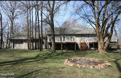
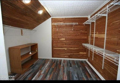
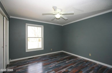
Spacious 5-bedroom, 2-bathroom split-level home in the desirable Heritage Acres subdivision. The kitchen features elegant Cambria quartz countertops. The main level offers three bedrooms, with two additional bedrooms located in the basement. Enjoy outdoor living on the large, beautiful deck at the back of the house. The property is also equipped with energy-efficient solar panels.
| Year | Tax Paid | Tax Assessment Tax Assessment Total Assessment is a certain percentage of the fair market value that is determined by local assessors to be the total taxable value of land and additions on the property. | Land | Improvement |
|---|---|---|---|---|
| 2025 | $1,738 | $46,270 | $5,700 | $40,570 |
| 2024 | $1,738 | $41,220 | $5,700 | $35,520 |
| 2023 | $1,738 | $41,220 | $5,700 | $35,520 |
| 2022 | $1,718 | $40,890 | $5,700 | $35,190 |
| 2021 | $1,706 | $40,890 | $5,700 | $35,190 |
| 2020 | $1,613 | $38,100 | $5,700 | $32,400 |
| 2019 | $1,618 | $38,100 | $5,700 | $32,400 |
| 2018 | $1,385 | $32,690 | $0 | $0 |
| 2017 | $1,389 | $32,690 | $0 | $0 |
| 2016 | $1,318 | $31,150 | $0 | $0 |
| 2015 | $1,315 | $31,150 | $0 | $0 |
| 2014 | $1,315 | $31,150 | $0 | $0 |
| Date | Event | Price | List to Sale | Price per Sq Ft |
|---|---|---|---|---|
| 01/30/2026 01/30/26 | Off Market | $2,500 | -- | -- |
| 12/30/2025 12/30/25 | Price Changed | $2,500 | 0.0% | $1 / Sq Ft |
| 12/30/2025 12/30/25 | For Rent | $2,500 | 0.0% | -- |
| 11/02/2025 11/02/25 | For Sale | $499,900 | 0.0% | $144 / Sq Ft |
| 10/27/2024 10/27/24 | Off Market | $2,350 | -- | -- |
| 10/08/2024 10/08/24 | Off Market | $2,350 | -- | -- |
| 09/28/2024 09/28/24 | For Rent | $2,350 | 0.0% | -- |
| 05/01/2022 05/01/22 | For Rent | $2,350 | -- | -- |
| Date | Type | Sale Price | Title Company |
|---|---|---|---|
| Warranty Deed | -- | None Available | |
| Quit Claim Deed | -- | -- |
| Date | Status | Loan Amount | Loan Type |
|---|---|---|---|
| Open | $238,500 | New Conventional |
**Meet the Difference-Maker in Webb City Real Estate!**
As the visionary founder of The Genuine Team, brokered by Epique Realty in the Joplin, Carl Junction, Webb City and surrounding areas in SWMO, I have dedicated my career to transforming the real estate experience for home-buyers and sellers in our community. My relentless commitment to professionalism, integrity, and personalized service sets me apart as an expert real estate agent who delivers results.
I pride myself on
$53,900
There are two lots included in this sale - they total 1.1 acres
Julie Williams Epique Realty
$319,900
This beautifully remodeled home in the Briarbrook subdivision truly stands out, thanks to its updated kitchen and baths. The kitchen boasts elegant granite countertops, a stylish tile backsplash, and durable tile flooring, seamlessly opening to the family room with views of the backyard. The bathrooms mirror this elegance with granite counters, intricately detailed tile showers, and tile floors.
Julie Williams Epique Realty
$24,900
This parcel is suitable to build a duplex on or a sizable home. There are utilities to property and access on street and alley. This large lot is gorgeous and has mature trees with plenty of open space to build a home or duplex.
Julie Williams Epique Realty
$3,000,000
Discover a breathtaking 235-acre paradise featuring multiple buildings, expansive pastures, and untouched woodlands with mature trees. The property boasts an efficient irrigation system, a spring-fed pond, and a charming log cabin. Equipped with two 3-phase electric grids capable of supporting multiple homes and three connector boxes, this estate is perfect for large-scale farming. It includes
Julie Williams Epique Realty
$269,990 Sold Jul 06, 2025
This beautiful Victorian in Webb City is close to downtown Webb City, boasting a wrap-around porch, 5-7 bedrooms, all rooms are large, laundry on 2nd floor, claw-foot tub, hardwood floors, original beautiful wood framing, fireplace, additional room built as an extra living quarters or entertainment room, large carport.Be sure to send this to your Realtor to put on your list of showings. This
Julie Williams Epique Realty
$74,900 Sold Mar 05, 2026
This home is in a great area, scenic and beautiful. This home is highly desired, it needs a lot of work but will be worth it when done!
Julie Williams Epique Realty
$189,900 Sold Mar 09, 2026
Public Remarks: UPDATE: BRAND NEW KITCHEN! Due to a previous leak under the sink, the kitchen has been completely remodeled. It now features new flooring, cabinets, granite countertops, and appliances. This 3-bedroom, 2-bathroom home is located in a quiet neighborhood within the Carl Junction School District. Enjoy the spacious 1⁄2 acre yard and relax on one of the two covered porches. The house
Julie Williams Epique Realty
Source: Ozark Gateway Association of REALTORS®
MLS Number: 256095
APN: 15-5.0-15-40-006-038.000
Disclaimer: Certain information contained herein is derived from information provided by parties other than Homes.com. All information provided is deemed reliable, but is not guaranteed to be accurate and should be independently verified.
![]() IDX information is provided exclusively for personal, non-commercial use, and may not be used for any purpose other than to identify prospective properties consumers may be interested in purchasing. Information is deemed reliable but not guaranteed.
IDX information is provided exclusively for personal, non-commercial use, and may not be used for any purpose other than to identify prospective properties consumers may be interested in purchasing. Information is deemed reliable but not guaranteed.
Ask me questions while you tour the home.