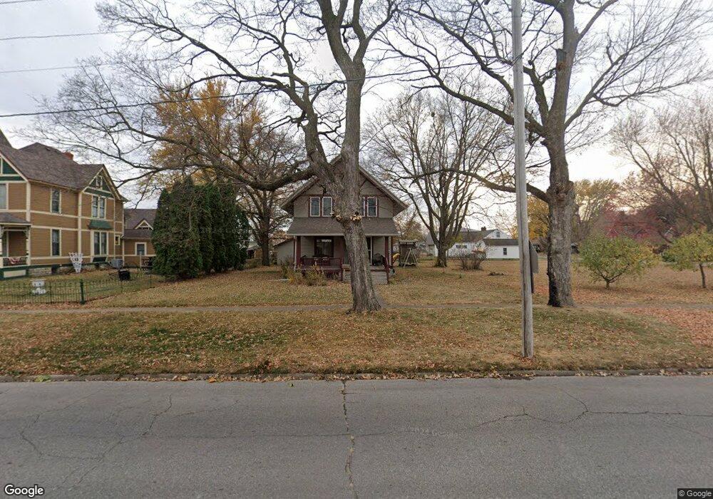
202 W Main St La Porte City, IA 50651
Estimated Value: $129,000 - $162,000
3
Beds
2
Baths
1,344
Sq Ft
$111/Sq Ft
Est. Value
About This Home
This home is located at 202 W Main St, La Porte City, IA 50651 and is currently estimated at $148,695, approximately $110 per square foot. 202 W Main St is a home located in Black Hawk County with nearby schools including Union High School.
Ownership History
Date
Name
Owned For
Owner Type
Purchase Details
Closed on
Aug 31, 2007
Sold by
Hinz Solomon D and Hinz Madeline J
Bought by
Hemsath Craig and Hemsath Brynna
Current Estimated Value
Home Financials for this Owner
Home Financials are based on the most recent Mortgage that was taken out on this home.
Original Mortgage
$80,000
Outstanding Balance
$50,781
Interest Rate
6.71%
Mortgage Type
New Conventional
Estimated Equity
$97,914
Purchase Details
Closed on
Apr 3, 2006
Sold by
The Estate Of Chad R Bucknell and Bucknell Richard J
Bought by
Hinz Solomon D and Watson Madeline J
Home Financials for this Owner
Home Financials are based on the most recent Mortgage that was taken out on this home.
Original Mortgage
$81,362
Interest Rate
5.75%
Mortgage Type
Adjustable Rate Mortgage/ARM
Create a Home Valuation Report for This Property
The Home Valuation Report is an in-depth analysis detailing your home's value as well as a comparison with similar homes in the area
Home Values in the Area
Average Home Value in this Area
Purchase History
| Date | Buyer | Sale Price | Title Company |
|---|---|---|---|
| Hemsath Craig | $80,000 | None Available | |
| Hinz Solomon D | $79,000 | None Available |
Source: Public Records
Mortgage History
| Date | Status | Borrower | Loan Amount |
|---|---|---|---|
| Open | Hemsath Craig | $80,000 | |
| Previous Owner | Hinz Solomon D | $81,362 |
Source: Public Records
Tax History Compared to Growth
Tax History
| Year | Tax Paid | Tax Assessment Tax Assessment Total Assessment is a certain percentage of the fair market value that is determined by local assessors to be the total taxable value of land and additions on the property. | Land | Improvement |
|---|---|---|---|---|
| 2025 | $1,994 | $128,040 | $13,230 | $114,810 |
| 2024 | $1,994 | $123,730 | $13,230 | $110,500 |
| 2023 | $1,794 | $123,730 | $13,230 | $110,500 |
| 2022 | $1,742 | $97,890 | $13,230 | $84,660 |
| 2021 | $1,772 | $97,890 | $13,230 | $84,660 |
| 2020 | $1,682 | $93,450 | $10,290 | $83,160 |
| 2019 | $1,682 | $93,450 | $10,290 | $83,160 |
| 2018 | $1,664 | $93,450 | $10,290 | $83,160 |
| 2017 | $1,686 | $93,450 | $10,290 | $83,160 |
| 2016 | $1,652 | $93,450 | $10,290 | $83,160 |
| 2015 | $1,652 | $93,450 | $10,290 | $83,160 |
| 2014 | $1,664 | $93,450 | $10,290 | $83,160 |
Source: Public Records
Map
Nearby Homes
- 307 W Main St
- 12 Bluff St
- 506 Commercial St Unit L
- 713 Locust St
- 505 Sycamore St
- 115 Primrose Ln
- 301 Walnut St
- 104 Westridge Ct
- 700 3rd St
- 809 Pine St
- 804 3rd St
- 0 Anton Dr
- 903 Poplar St Unit 905
- Lot 1 Sweet 3rd Addition
- Lot 2 Sweet 2nd Addition
- Lot 1 Sweet 2nd Addition
- Lot 3 Sweet 2nd Addition
- Lot 5 Sweet 2nd Addition
- Lot 6 Sweet 2nd Addition
- 1308 South St