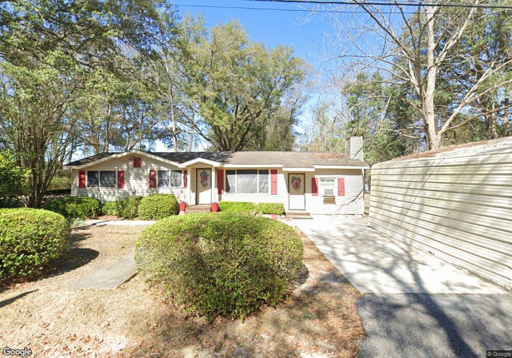
2020 Beverly Dr Valdosta, GA 31601
Estimated Value: $47,000 - $99,000
--
Bed
1
Bath
1,111
Sq Ft
$58/Sq Ft
Est. Value
About This Home
This home is located at 2020 Beverly Dr, Valdosta, GA 31601 and is currently estimated at $64,006, approximately $57 per square foot. 2020 Beverly Dr is a home located in Lowndes County with nearby schools including Westside Elementary School, Hahira Middle School, and Lowndes High School.
Ownership History
Date
Name
Owned For
Owner Type
Purchase Details
Closed on
Apr 9, 2025
Sold by
Brown Alberta
Bought by
Miller Barbara Ann
Current Estimated Value
Home Financials for this Owner
Home Financials are based on the most recent Mortgage that was taken out on this home.
Original Mortgage
$103,423
Outstanding Balance
$102,871
Interest Rate
6.65%
Mortgage Type
New Conventional
Estimated Equity
-$38,865
Purchase Details
Closed on
May 23, 1995
Sold by
Neloms Willie Mae
Bought by
Jones Maxine N and Alberta Brown
Create a Home Valuation Report for This Property
The Home Valuation Report is an in-depth analysis detailing your home's value as well as a comparison with similar homes in the area
Home Values in the Area
Average Home Value in this Area
Purchase History
| Date | Buyer | Sale Price | Title Company |
|---|---|---|---|
| Miller Barbara Ann | $45,000 | -- | |
| Jones Maxine N | -- | -- |
Source: Public Records
Mortgage History
| Date | Status | Borrower | Loan Amount |
|---|---|---|---|
| Open | Miller Barbara Ann | $103,423 |
Source: Public Records
Tax History Compared to Growth
Tax History
| Year | Tax Paid | Tax Assessment Tax Assessment Total Assessment is a certain percentage of the fair market value that is determined by local assessors to be the total taxable value of land and additions on the property. | Land | Improvement |
|---|---|---|---|---|
| 2024 | $203 | $16,932 | $2,400 | $14,532 |
| 2023 | $203 | $15,988 | $2,400 | $13,588 |
| 2022 | $113 | $12,707 | $2,400 | $10,307 |
| 2021 | $116 | $12,707 | $2,400 | $10,307 |
| 2020 | $111 | $12,707 | $2,400 | $10,307 |
| 2019 | $111 | $12,707 | $2,400 | $10,307 |
| 2018 | $112 | $12,707 | $2,400 | $10,307 |
| 2017 | $106 | $12,707 | $2,400 | $10,307 |
| 2016 | $106 | $12,707 | $2,400 | $10,307 |
| 2015 | $103 | $12,707 | $2,400 | $10,307 |
| 2014 | $104 | $12,707 | $2,400 | $10,307 |
Source: Public Records
Map
Nearby Homes
- 2048 Dean St
- 2097 Lynnhaven Rd
- 2419 Treeview Dr
- 0 James Rd
- 201 Norman Dr
- 1817 W Hill Ave
- 2337 W Savannah Ave
- 211 Stella St
- 303 Nan St
- 1690 Ridgecrest St
- 107 Jordan St
- 230 Saint Augustine Rd
- 219 N St Augustine Rd
- 203 N Saint Augustine Rd
- TBD Moss Oak Dr
- 605 N Saint Augustine Rd
- 316 Blitch St
- 1430 W Magnolia St
- 0 Saint Augustine Rd
- 493 Saint Augustine Rd S
- 2010 Beverly Dr
- 2040 Beverly Dr
- 2030 Dean St
- 2054 Beverly Dr
- 2063 Dean St
- 2039 Dean St
- 2023 Lynnhaven Rd
- 2027 Lynnhaven Rd
- 2067 Lynnhaven Rd
- 2020 Lynnhaven Rd
- 2068 Dean St
- 2060 Smith St
- 2073 Lynnhaven Rd
- 2040 Lynnhaven Rd
- 0
- 2079 Lynnhaven Rd
- 2132 Jeremiah Cir
- 2073 Holland Cir
- 2130 Jeremiah Cir
- 2063 Holland Cir