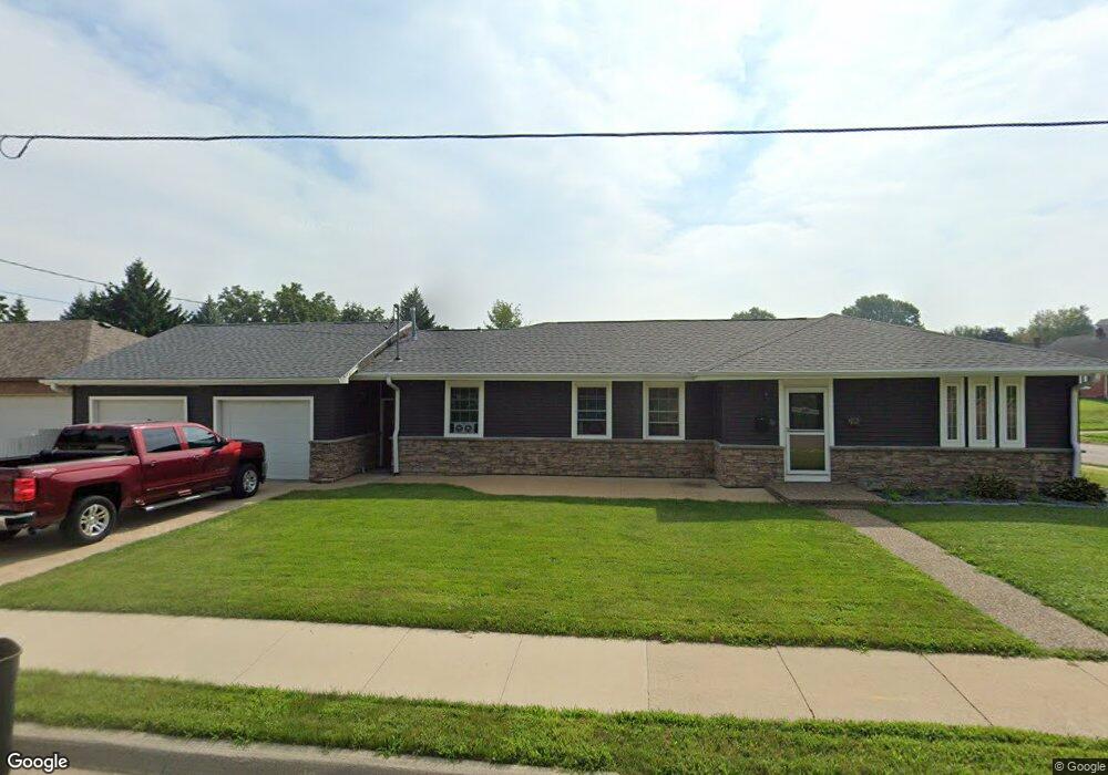
2020 Bunker Hill Rd Dubuque, IA 52001
Estimated Value: $282,000 - $321,000
4
Beds
3
Baths
1,544
Sq Ft
$196/Sq Ft
Est. Value
About This Home
This home is located at 2020 Bunker Hill Rd, Dubuque, IA 52001 and is currently estimated at $302,815, approximately $196 per square foot. 2020 Bunker Hill Rd is a home located in Dubuque County with nearby schools including Irving Elementary School, George Washington Middle School, and Dubuque Senior High School.
Ownership History
Date
Name
Owned For
Owner Type
Purchase Details
Closed on
Dec 30, 2004
Sold by
Brunkow Fred J and Brunkow Sharon
Bought by
Thomas Shawn M and Thomas Peggy S
Current Estimated Value
Home Financials for this Owner
Home Financials are based on the most recent Mortgage that was taken out on this home.
Original Mortgage
$110,000
Outstanding Balance
$55,711
Interest Rate
5.9%
Mortgage Type
New Conventional
Estimated Equity
$247,104
Create a Home Valuation Report for This Property
The Home Valuation Report is an in-depth analysis detailing your home's value as well as a comparison with similar homes in the area
Home Values in the Area
Average Home Value in this Area
Purchase History
| Date | Buyer | Sale Price | Title Company |
|---|---|---|---|
| Thomas Shawn M | $110,000 | None Available |
Source: Public Records
Mortgage History
| Date | Status | Borrower | Loan Amount |
|---|---|---|---|
| Open | Thomas Shawn M | $110,000 |
Source: Public Records
Tax History Compared to Growth
Tax History
| Year | Tax Paid | Tax Assessment Tax Assessment Total Assessment is a certain percentage of the fair market value that is determined by local assessors to be the total taxable value of land and additions on the property. | Land | Improvement |
|---|---|---|---|---|
| 2025 | $4,136 | $336,600 | $42,700 | $293,900 |
| 2024 | $4,136 | $296,100 | $38,700 | $257,400 |
| 2023 | $4,014 | $296,100 | $38,700 | $257,400 |
| 2022 | $3,794 | $238,410 | $36,640 | $201,770 |
| 2021 | $3,794 | $238,410 | $36,640 | $201,770 |
| 2020 | $3,632 | $213,070 | $34,600 | $178,470 |
| 2019 | $3,634 | $213,070 | $34,600 | $178,470 |
| 2018 | $3,386 | $204,010 | $32,570 | $171,440 |
| 2017 | $3,232 | $193,650 | $32,570 | $161,080 |
| 2016 | $3,232 | $175,920 | $32,570 | $143,350 |
| 2015 | $3,164 | $175,920 | $32,570 | $143,350 |
| 2014 | $3,068 | $175,440 | $32,570 | $142,870 |
Source: Public Records
Map
Nearby Homes
- 1896 Floraview Dr
- 1949 Saint Ambrose St
- 1821 Glendale Ct
- 2425 Green St
- 2422 University Ave
- 1629 McPoland Ave
- 2485 Pearl St
- 1568 Fairfax Ave
- 2035 Broadlawn Rd
- 1650 Drexel Ave
- 1414 N Algona St
- 2535 Mineral St
- 1395 Brown Ave
- 1615 Adair St
- 2628 University Ave
- 2995 Asbury Rd
- 2685 Renaissance Dr
- 1820 Eden Ln
- 1735 Wood St
- 2347 Coventry Park Unit C-011
- 2185 Clarke Dr
- 2040 Bunker Hill Rd
- 2175 Clarke Dr
- 2025 Bunker Hill Rd
- 2196 Clarke Dr
- 2055 Bunker Hill Rd
- 1980 Bunker Hill Rd
- 2165 Clarke Dr
- 2060 Bunker Hill Rd
- 1982 Asbury Rd
- 2085 Bunker Hill Rd
- 2174 Clarke Dr
- 1984 Asbury Rd
- 1980 Asbury Rd
- 1986 Asbury Rd
- 1960 Bunker Hill Rd
- 2155 Clarke Dr
- 2188 Sunnyview Dr
- 2160 Clarke Dr
- 1970 Asbury Rd