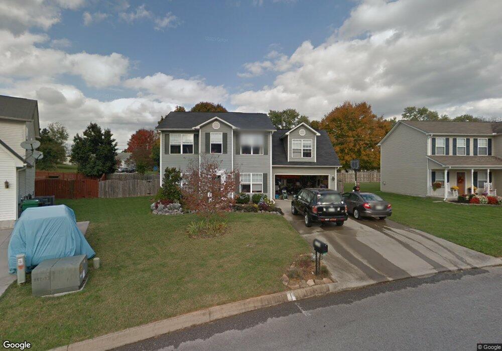
2020 Farmstead Ln Powell, TN 37849
Estimated Value: $382,000 - $397,000
3
Beds
3
Baths
1,932
Sq Ft
$201/Sq Ft
Est. Value
About This Home
This home is located at 2020 Farmstead Ln, Powell, TN 37849 and is currently estimated at $387,735, approximately $200 per square foot. 2020 Farmstead Ln is a home located in Knox County with nearby schools including Powell Elementary School, Powell Middle School, and Powell High School.
Ownership History
Date
Name
Owned For
Owner Type
Purchase Details
Closed on
May 18, 2007
Sold by
Curtis Jason and Curtis Bonnie
Bought by
Bresler Nathan M and Bresler Linda C
Current Estimated Value
Home Financials for this Owner
Home Financials are based on the most recent Mortgage that was taken out on this home.
Original Mortgage
$26,250
Interest Rate
5.85%
Mortgage Type
Stand Alone Second
Purchase Details
Closed on
Apr 22, 2005
Sold by
Luttrell Development Llc
Bought by
Curtis Jason and Curtis Bonnie
Home Financials for this Owner
Home Financials are based on the most recent Mortgage that was taken out on this home.
Original Mortgage
$116,808
Interest Rate
6.94%
Mortgage Type
Fannie Mae Freddie Mac
Create a Home Valuation Report for This Property
The Home Valuation Report is an in-depth analysis detailing your home's value as well as a comparison with similar homes in the area
Home Values in the Area
Average Home Value in this Area
Purchase History
| Date | Buyer | Sale Price | Title Company |
|---|---|---|---|
| Bresler Nathan M | $175,000 | None Available | |
| Curtis Jason | $146,010 | -- |
Source: Public Records
Mortgage History
| Date | Status | Borrower | Loan Amount |
|---|---|---|---|
| Closed | Bresler Nathan M | $26,250 | |
| Open | Bresler Nathan M | $140,000 | |
| Previous Owner | Curtis Jason | $116,808 | |
| Closed | Curtis Jason | $29,202 |
Source: Public Records
Tax History Compared to Growth
Tax History
| Year | Tax Paid | Tax Assessment Tax Assessment Total Assessment is a certain percentage of the fair market value that is determined by local assessors to be the total taxable value of land and additions on the property. | Land | Improvement |
|---|---|---|---|---|
| 2024 | $978 | $62,950 | $0 | $0 |
| 2023 | $978 | $62,950 | $0 | $0 |
| 2022 | $978 | $62,950 | $0 | $0 |
| 2021 | $934 | $44,075 | $0 | $0 |
| 2020 | $934 | $44,075 | $0 | $0 |
| 2019 | $934 | $44,075 | $0 | $0 |
| 2018 | $934 | $44,075 | $0 | $0 |
| 2017 | $934 | $44,075 | $0 | $0 |
| 2016 | $974 | $0 | $0 | $0 |
| 2015 | $974 | $0 | $0 | $0 |
| 2014 | $974 | $0 | $0 | $0 |
Source: Public Records
Map
Nearby Homes
- 7832 Brickyard Rd
- 2100 Cartmill Dr
- 7708 Ambergate Rd
- 7922 Harmon Rd
- 6043 Sweet Bell Ave Unit Lot 183
- 4522 Unity Bell Ave Unit Lot 165
- 6027 Sweet Bell Ave Unit Lot 179
- 7136/7140 Lightning Way
- 7624 Camden Rd
- 8024 Sharp Rd
- 1208 Lula Bell Dr
- 8017 Little Joe Rd
- 2300 Bainbridge Way
- 8000 Little Joe Rd
- 8114 Sharp Rd
- 7604 Berkshire Blvd
- 7704 Collier Rd
- 7810 Galaxy Way Unit 11
- 2812 Staffordshire Blvd
- 1134 Paradise Dr
- 2016 Farmstead Ln
- 2024 Farmstead Ln
- 2012 Farmstead Ln
- 2028 Farmstead Ln
- 2029 Farmstead Ln
- 2015 Farmstead Ln
- 2032 Farmstead Ln
- 7838 Brickyard Rd
- 2008 Farmstead Ln
- 7836 Brickyard Rd
- 2035 Farmstead Ln
- 2011 Farmstead Ln
- 7842 Brickyard Rd
- 2036 Farmstead Ln
- 7846 Dawnview Rd
- 2004 Farmstead Ln
- 7854 Dawnview Rd
- 2040 Farmstead Ln
- 2005 Farmstead Ln
- 2000 Farmstead Ln